Rajasthan Board RBSE Class 11 Indian Geography Chapter 11 Natural Disasters and Management (Flood, Drought and Sea Storm)
RBSE Class 11 Indian Geography Chapter 11 Text Book Questions
RBSE Class 11 Indian Geography Chapter 11 Multiple Choice Type Questions
Question 1.
The river which is called the Sorrow of Bengal is:
(a) Kosi
(b) Damodar
(c) Ganga
(d) Subarnarekha
Answer:
(b) Damodar
Question 2.
The cyclones that are known as storms in India are:
(a) Temperate cyclones
(b) Winter cyclones
(c) Tropical cyclones
(d) Desert cyclones
Answer:
(b) Winter cyclones
Question 3.
The region of India in which drought occurs mostly is:
(a) Northern Plains
(b) East – Northern region
(c) Western region
(d) Coastal region
Answer:
(c) Western region
RBSE Class 11 Indian Geography Chapter 11 Very Short Answer Type Questions
Question 1.
What is flood?
Answer:
An overflow of a large amount of water beyond its normal limits, especially over what is normally dry land. It may be unusual build – up, run – off of surface water or abnormal erosion or undermining of shoreline.
Question 2.
In which part of India most of floods occur?
Answer:
Most of the floods occur in the Northern and North – Eastern plains of India.
Question 3.
Which river is called as the Sorrow of Bihar?
Answer:
River Kosi is called as the Sorrow of Bihar.
Question 4.
What is the main cause of drought?
Answer:
The main cause of drought is insufficient rainfall.
Question 5.
In which months sea storms occur in India?
Answer:
In India, most of the sea storms occur in the months of June, July and August. But they also occur in the month April to December in the Bay of Bengal and Arabian Sea.
RBSE Class 11 Indian Geography Chapter 11 Short Answer Type Questions
Question 1.
Which are the flood affected regions in India?
Answer:
The amount of rainfall and its distribution decide the flood affected areas in India. More than 90 per cent of floods of India occur in the northern and north – eastern plains. With the point view of floods, India has been divided into four zones:
1. Northern Plains:
The overflow of rivers Yamuna, Gomati, Ghaghara, Gandak, Kosi, Sutlej, Ravi, Beas, Jhelam and Chinab cause flood in this region.
2. North – Easter n Plains:
The overflow of River Brahmaputra causes floods in this area.
3. Central India region:
Floods occur in this part of India due to overflow of the Rivers , Chambal, Son, Betwa, and Damodar.
4. Southern India region:
The bank areas of rivers Godavari, Mahanadi, Krishna, Cauvery are included in this zone.
Question 2.
Explain the term ‘Trikal’.
Answer:
When there is a very low amount of rainfall for a long period, there is a need of water all around. Due to the shortage of water, there is no agriculture, no vegetation in any affected region, also, there is no drinking water. The condition, in which there is extreme shortage of food grains for people and fodder for cattle and livestock and lack of drinking water for all the living beings, is called Trikal.
Question 3.
Give suggestions for controlling floods.
Answer:
The problem of flood arises mainly due to uncontrolled water flow. So, controlling the flood is directly related to water flow. Following suggestions can be given to reduce or control its impact:
- Dams should be built to check the over flow of water of rivers.
- Aforestation is most important in flood affected areas to reduce the intensity of flood.
- During the construction of roads and railways, the water flow routes of rivers or rainwater must not be blocked or disturbed.
- The water containing capacity of rivers should be increased before rainy season.
- The silt of the rivers should be dug – out, so that their water containing capacity may increase.
- The barriers of the rivers should be built strong enough and high.
- Proper means of transport and communication should be made available in the affected areas.
Question 4.
Describe the origin of sea storms.
Answer:
A sea storm, storm surge, storm flood or storm tide is a coastal flood or Tsunami – like phenomenon of rising water, commonly associated with low pressure weather system (such as tropical cyclones and strong extra tropical cyclones).
The severity of a sea storm is affected by the shallowness and orientation of the water body relative to storm path, as well as the timing of tides. Most casualties during tropical cyclones occur as the result of storm surges, it is a measure of the rise of water beyond what is expected by the normal movement related to tides.
The two major meteorological factors contributing to a storm surge are a long stretch of winds spiraling inward towards the storm, and a low pressure induced dome of water drawn up under and trailing the storm’s center.
RBSE Class 11 Indian Geography Chapter 11 Essay Type Questions
Question 1.
What are the causes of frequent occurrence of floods in India?
Answer:
Many factors are responsible for frequent occurrence floods in India. But mainly, the following factors are considered to be responsible for occurrence of floods: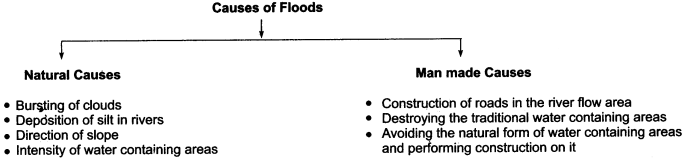
1. Heavy Rainfall:
Areas which are subject to intense floods are mainly located in the plains of North India. It is estimated that over 90 per cent of the total damage done to property and crops in India takes place in the plains of Northern India alone. The lower Narmada and the lower Tapti Valleys, the Deltas of Mahanadi, the Godavari and Krishna are also inundated from time to time.
Heavy rainfall in the catchment areas of rivers and in the poorly drained areas is the major cause of occurence of floods. Spells of unusually heavy rains occur during the summer monsoon rainy season except in Tamil Nadu where some areas may be flooded during winter.
2. Bad Drainage and Congestion System:
In the plains of Uttar Pradesh and Bihar, large areas are inundated where the Ganga receives its left bank tributaries as Ghaghara, Gandhak, Burhi Gandak and Kosi, also the right bank tributary, the Son, during the rainy season. Near the confluences of these tributaries, along with Ganga, the free flow of their water is obstructed when the Ganga itself is in flood.
Owing to this congestion of water, the water level rises in the tributaries, sometimes causing floods in the neighboring areas. The inter – flow between the left bank tributaries of the Ganga are drained by rivulets which also increase the intensity of floods.
3. Annual Deposition of Silt:
The Rivers Kosi, Tista, Torsa and a number of other rivers drain large catchment areas in the Himalayas. Laden with heavy charge of sand and silt, they emerge from the Himalayan gorges and enter the leveled plains where they lose speed. Decline in the speed of water flow results in the deposition of the load and spread of water over large areas. The annual deposition of silt and sand raises the bed and thus reduces the capacity of the river to accommodate flood water.
4. Land Depression:
The Assam Valley is another fertile belt which is affected sometimes seriously by flood havoc. Heavy rainfall amounting to over 250 cm during the rainy season in North – Eastern Assam is the chief cause of the floods in the Assam Valley. Brahmaputra, which drains this valley, receives from its tributaries, Dibang and Luhit Rivers, a large amount of water heavily laden with silt. The silt which is deposited in the river channels makes it shallow. Thus, the capacity of the rivers to carry a large amount of water is reduced. Besides, landslides are frequent in north – eastern Assam.
5. Deforested Catchment Areas:
Floods are almost a regular feature in the coastal low land of Orissa. Devastating inundations occur in this belt almost every other year. Here, the major causes of floods are the deforested catchment areas of the rivers and the offshore bars which choke the mouths of the rivers and obstruct the free flow of water into the sea. Owing to the deposition of silt in the deltas, rivers have the tendency to change their course here.
6. Cyclonic Storms:
The deltas of Godavari and Krishna have also suffered from floods time and again. Lower courses of the Narmada and Tapti have to face a similar fate. Floods in these areas also result from incessant rains and occurrence of high tides at the time when the rivers are in spate. In the plateau of Peninsular India, south to the Satpura Range, floods are not only far less destructive, but also far less recurrent than in the other parts of the country.
This is due to the fact that here the rainfall is relatively less and load carried by the rivers is also less. The elements of modern civilization such as roads, embankments, railways and canals also obstruct the flow of water and thus cause floods. Near the oqastal areas, devastating floods have been caused by the cyclonic storms, particularly when they hit the coastal areas at the time of high tides.
Question 2.
What type of management should be made to face the problem of famine?
Answer:
A famine is created due to the natural disaster named drought, which is directly related to the availability of water. The intensity of famine is inversely proportional to the availability of water. On the basis of scarcity of water, it is divided into food grain famine, and bi – famine tri – famine. To avoid and to solve this problem, the following steps should be taken:
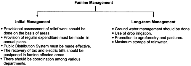
- To reduce the intensity of famine, management of ground water may prove to be the most helpful. Therefore, to search for ground water reserves, latest and modern technology like distance communication, satellite, mapping and Geographic Information System (GIS) should be adopted.
- Water storage areas should be developed in every village.
- To raise the ground water level in the villages, various small anicuts should be made.
- The common public should help the local government for developing the water storage areas.
- There should be water harvesting system in every house and in every building.
- The strong fencing of fields should be done, so that rain water may not flow out and moisture may be retained in the soil for a long time.
- Continuous efforts should be made to raise the ground water level.
- Such crops that need minimum water to grow should be encouraged, so that the water may be saved.
- Drop irrigation method should be adopted in fields.
- In canal regions, water seepage and vapouration should be minimized, so that saved water may be used for other purposes.
- Tourism should be promoted, so that the optional income sources may be developed and the dependence on agriculture may be reduced.
- Agriculture – forestry and meadows should be developed, so that the ground water level may rise up.
Question 3.
Explain the sea storms in detail.
Answer:
Storm conditions out at sea are defined as having sustained winds of speed be 48 knots or 90 km/hr or greater. In India, they are mostly known as cyclones. In India, their origin is related to Bay of Bengal and Arabian Sea.
Causes of their occurrence:
Sea storms are like giant engines that use warm moist air as fuel. That is why, they form only over warm ocean waters near the equator. The warm moist air over the ocean rises upwards from near the surface. Because this air moves up and away from the surface, there is less air left near the surface.
The occurrence of sea storms is mainly due to the conjunction of different type of air masses. Some scholars consider that their occurrence is due to the process of convection, often, the process of the change in the conditions of atmospheric pressure is held responsible for their occurrence.
Types of Sea Storm:
On the basis of air masses, sea storms are divided into two parts:
- Tropical cyclones
- Temperate cyclones.
In India, tropical cyclones arise in the Bay of Bengal and Arabian Sea, while temperate cyclones arise in the Indian Ocean.
Physical form of Sea Storms:
Sea storms are the center of least atmosphere pressure in which winds blow from outside towards the center. They have maximum speed in the oceanic region, but when they enter into the land, their speed is reduced. The greater the strength of the center of low air pressure, the greater distance they cover or they are violent.
The Effects and Problems which arise:
In India, these storms arise in the months of June, July and August in the Arabian Sea and in the month of December in the Bay of Bengal. These storms affect the states of Andhra Pradesh, Orissa and West Bengal, Due to these storms, there is immense loss of life and property, floods occur, trees get uprooted, buildings collapse, the boats are turned down and many other problems occur.
Sea storm management:
The sea storms cannot be stopped, so safety and rescue is the only remedy. To avoid their intensity, their pre – information should be broadcast and published, so that the public may become aware and stay protected. Individual honesty and dedication is very important and helpful to avoid their intensity. The government and social organisations should take rapid and effective steps to reduce their intensity.
Question 4.
Describe the problems and the solutions of flood – affected areas.
Answer:
Flood is a horrifying natural disaster which negatively impacts the human life. India faces huge loss every year due to floods. In the comparison of other natural disasters, floods are more horrible and life threatening in India. The problems that arise due to floods in India are as follows:
- A great loss of life and property takes place in the flood – affected areas every year in India. More than 150 lives are lost in India every year due to floods.
- More than 80 lakh hectares of land is affected by floods.
- Financially, there is a loss of over X 1000 crore in India every year, caused by floods.
- Crops sown in over 35 lakh hectare area are completely destroyed in floods every year.
- More than 12 lakh of livestock is affected by flood, out of which 2 lakh cattle die in floods every year in India.
- Approximately, three crore people are affected by floods every year.
- Thousands of houses collapse in floods and cause problems to human settlements there.
- Roads and railways are destroyed in floods and so the flood affected areas get disconnected from the remaining world.
- The resources of drinking water become polluted due to floods and cause many diseases.
- Due to spread of dirt in flood – affected areas, epidemics and infectious diseases spread
rapidly. - Floods cause harm to dams, canals and ponds.
Solutions to flood Problem:
- To dispel the flood problem, strong and high embankments should be built and also a proper drainage system should be developed.
- In the flood – affected regions, afforestation should be practiced in the water receiving areas of rives.
- The water containing capacity of rivers must be increased before rainy season.
- The silt deposited in the bottom of rivers should be cleaned before rainy season, so that water containing capacity of river may be increased.
- The routes, roads and railways should be built in this way that the natural flow of water may not be blocked or obstructed.
- Human settlements should not be developed in the water containing areas of rivers.
- Means of transportation and communication should be developed.
- Proper rescue operations should be conducted in the flood affected areas.
Map Based Questions
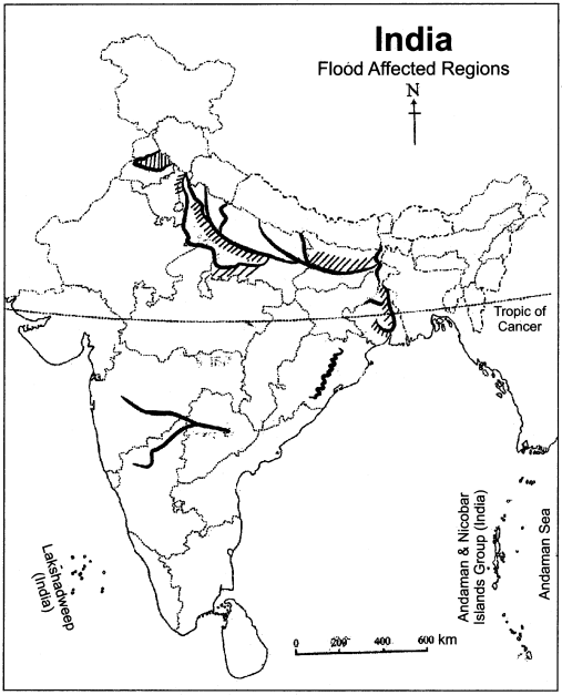
Question 1.
Show the flood affected regions on the map of India.
Answer:
The flood affected areas in India are as follows:
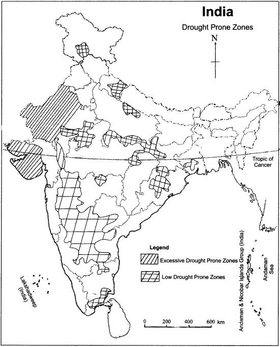
Question 2.
Show the drought prone zones on the map of India.
Answer:
Drought prone zones in India are as shown below:
Question 3.
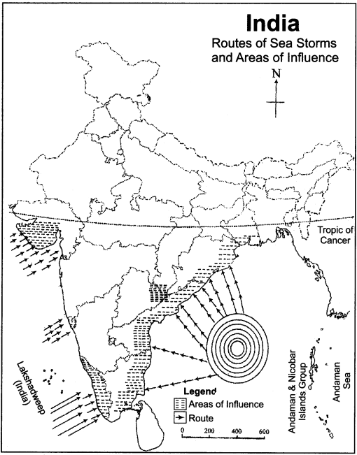
Show the routes of sea storms on the map of India.
Answer:
Following are the routes of sea storm and their areas of influence:
RBSE Class 11 Indian Geography Chapter 11 Other Important Questions
RBSE Class 11 Indian Geography Chapter 11 Multiple Choice Type Questions:
Question 1.
Which of these is not an area of maximum flood frequency?
(a) Brahmaputra region
(b) Lower Ganges Valley
(c) Kosi region
(d) Rajasthan
Answer:
(d) Rajasthan
Question 2.
The area in which most of the floods occur is:
(a) Madhya Pradesh
(b) Assam
(c) Uttarakhand
(d) Chhattisgarh
Answer:
(b) Assam
Question 3.
The speed of super cyclonic storm is:
(a) 88 – 117 km/hr
(b) 168 – 221 km/hr
(c) More than 222 km/hr
(d) Less than 52 km/hr
Answer:
(c) More than 222 km/hr
Question 4.
National Flood Control Project was started in:
(a) 1952
(b) 1954
(c) 1956
(d) 1955
Answer:
(b) 1954
Question 5.
Flood Forecasting Organisation was established in:
(a) 1951
(b) 1953
(c) 1954
(d) 1955
Answer:
(c) 1954
Question 6.
Government of India considers how much minimum annual amount of rainfall as the basis for declaration of drought:
(a) More than 100 cm
(b) Less than 10 cm
(c) More than 50 cm
(d) 10 cm to 50 cm
Answer:
(b) Less than 10 cm
Question 7.
Most of the drought affected areas in India are in:
(a) Rajasthan and Gujarat
(b) Madhya Pradesh and Bihar
(c) Punjab and Haryana
(d) Maharashtra and Karnataka
Answer:
(a) Rajasthan and Gujarat
Question 8.
How many districts in India have been considered as drought prone regions?
(a) 57 districts
(b) 67 districts
(c) 77 districts
(d) 87 districts
Answer:
(c) 77 districts
Question 9.
The winter rainfall in North – Western India is known as:
(a) Pre – monsoon
(b) Mango Showers
(c) Mavath
(d) Kal Baisakhi
Answer:
(c) Mavath
Question 10.
Cyclones of Bay of Bengal take place:
(a) From January to February
(b) From June to July
(c) From August to September
(d) From October to December
Answer:
(d) From October to December
Question 11.
More than 50 per cent loss due to floods occurs in two states of:
(a) Punjab and Haryana
(b) Madhya Pradesh and Maharashtra
(c) Uttar Pradesh and Bihar
(d) Karnataka and Tamil Nadu
Answer:
(c) Uttar Pradesh and Bihar
Question 12.
In which state of India is the drought a permanent disaster?
(a) Maharashtra and Madhya Pradesh
(b) Rajasthan and Gujarat
(c) Punjab and Uttar Pradesh
(d) Orissa and Andhra Pradesh
Answer:
(b) Rajasthan and Gujarat
Matching Type Questions
Question A.
Match Column A with Column B:
| Column A (Type of disaster) | Column B (Affected area) |
| (i) Floods | (a) Himachal Pradesh |
| (ii) Drought | (b) Andhra Pradesh |
| (iii) Sea Storm | (c) Uttarakhand |
| (vi) Earthquake | (d) Rajasthan |
| (v) Landslides | (e) Assam |
Answers:
- (e)
- (d)
- (b)
- (a)
- (c)
Question B.
Match Column A with Column B:
| Column A (Disaster) | Column B (Cause of disaster) |
| (i) Flood | (a) Plate tectonics |
| (ii) Drought | (b) Conjunction of various air – masses |
| (iii) Sea Storm | (c) Deposition of silt in the rivers |
| (vi) Earthquake | (d) Less amount Of rainfall |
Answers:
- (c)
- (d)
- (b)
- (a)
Question C.
Match Column A with Column B :
| Column A | Column B |
| (i) Cyclonic Storm | (a) Uncertainty of less than 25 per cent than normal. |
| (ii) Firece drought | (b) Vikram Samvat 1956 |
| (iii) Normal drought | (c) Convection process |
| (vi) Famine of Chhappan | (d) Winds at the rate of 62 – 87 km/hr |
| (v) Sea Storm | (e) Uncertainty of more than 25 per cent than normal |
Answers:
- (d)
- (e)
- (a)
- (b)
- (c)
RBSE Class 11 Indian Geography Chapter 11 Very Short Answer Type Questions
Question 1.
What is meant by drought?
Answer:
A drought is a period of below-average precipitation in a given region, resulting in prolonged shortage in the water supply, whether atmospheric, surface water or ground water.
Question 2.
Why do floods occur?
Answer:
A flood occurs when water overflows or inundates land that is normally dry.
Question 3.
Why does drought occur?
Answer:
Drought occurs when there is not enough rainfall for a long time period. It is not like a dry spell, there is so little precipitation (rain, snow, sleet) that the entire region starts to dry out.
Question 4.
According to the Indians, what are natural disasters?
Answer:
According to common Indians, natural disasters are regarded as the wrath of God.
Question 5.
Where do the devastating floods occur?
Answer:
The devastating floods occur in Kosi river flow region in Bihar and Damodar river flow region in West Bengal.
Question 6.
Which are the Tsunami – affected areas in India?
Answer:
The Tsunami – affected areas in India include the coastal regions of Orissa, Andhra Pradesh, Tamil Nadu, and Kerala.
Question 7.
Into how many parts have the cyclonic storms been divided on the basis of their intensity?
Answer:
On the basis of their intensity, cyclonic storms are divided into Tropical cyclones, Hurricanes, Typhoons and Tornadoes.
Question 8.
Why is the hideousness of floods caused by the Rivers of South India less than that of Rivers of Northern India?
Answer:
The water containing capacity of rivers in North India is lesser than the rivers of South India, therefore the hideousness of floods caused by South Indian rivers is lesser.
Question 9.
When does a flood become frightful?
Answer:
If there is regular heavy rainfall due to monsoon or seasonal conditions, then the situation like the bursting of clouds takes form and then a flood becomes frightful.
Question 10.
By which natural disaster most loss is caused in India?
Answer:
The disaster like flood causes the most loss in India.
Question 11.
Which are the main flood – prone areas in India?
Answer:
60% of the loss caused due to floods takes place only in the states of Uttar Pradesh and Bihar. Apart from these, Assam, West Bengal and Orissa are other major flood-prone regions.
Question 12.
Which multipurpose projects have been established in India for flood management?
Answer:
Mainly, Bhakhra – Nangal dam project, Damodar Valley, Mahanadi Valley (Hirakud), Farakka, Idukki, Tehri, Ramganga, Rana Pratap Sagar and Sutlej – Beas Projects have been started for flood management.
Question 13.
What should the people do during the occurrence of floods?
Answer:
During the occurrence of floods, people should follow the suggestions and orders given by the government. Electrical equipment should be switched off and getting into the water should be avoided in the flood prone areas without knowing their depth and velocity.
Question 14.
Name the drought – affected areas in India.
Answer:
Rajasthan, Gujarat, central Maharashtra, central and Eastern Karnataka, some region of Madhya Pradesh and Haryana are the main drought-affected areas in India.
Question 15.
What is the difference between drought and dry spell ?
Answer:
A drought is a prolonged period of abnormally low rainfall leading to a shortage of water, which can transform into a disaster. A dry spell is short period of low rainfall, lasting usually for not more than a month.
Question 16.
What is meant by food grain famine?
Answer:
Due to extremely less rainfall, crops get dried up and are destroyed. Due to this condition of rainfall, less crop production remains un – sufficient to support the public demand. This situation of shortage of food grains is called food grain famine.
Question 17.
What do you meant by bi-famine?
Answer:
When it is so little rainfall that neither food grain nor fodder for live-stocks is available, then the conditions thus created are called bi-famine. During this type of famine, both public as well as cattle starye.
Question 18.
What is meant by the Famine of Chhappan?
Answer:
India experienced the most horrific famine in the year 1900. It was very little rainfall since 1896 due to the El Nino effect. This fatal famine is known as the “Chhappan ka Akal” or the Famine of Chhappan.
Question 19.
From where do the tropical cyclones enter into India?
Answer:
The tropical cyclones arise in the ocean and enter into India through Bay of Bengal and Arabian Sea.
Question 20.
The winter cyclones that enter in North-Western India prove to be useful. How?
Answer:
In fact, the winter cyclones that enter into India are temperate cyclones which cause rainfall in the north – western part of India in the months of December and January. This rainfall is known as Mavath and it is very useful for the Rabi – crops. So, these cyclones prove to be useful for India.
Question 21.
Which are the most affected areas from cyclones in India?
Answer:
The most affected areas from cyclones in India are Andhra Pradesh, Orissa and West Bengal.
Question 22.
Explain with example the human casualties caused due to sea storms in India.
Answer:
Extreme human casualties take place due to sea storms in India, i.e. over 5000 people were killed in May 1833 in West Bengal, over 3000 people were killed in the sea storm in Orissa in October 1971, and in another such sea storm, 1000 lives were lost in Orissa in October 1999.
Question 23.
How is the indemnification of sea storms possible?
Answer:
The indemnification of sea storms is possible only by taking insurance. So, the people living at the coastal regions should take insurance of their belongings, livestock, crops and themselves.
Question 24.
Which new technologies should be used to explore the groundwater resources?
Answer:
In the condition of dry-spell, drought and famine, management of ground water may prove to be very useful. So, new ground water resources should be explored. For this purpose, remote sensing, satelite, mapping and Geographic Information System (GIS) should be used.
Question 25.
On which rivers, dams have been built under multipurpose projects?
Answer:
Under multipurpose projects, the dams have been built on the rivers Mahanadi, Damodar, Sutlej, Beas, Chambal, Narmada etc.
RBSE Class 11 Indian Geography Chapter 11 Short Answer Type Questions (SA-I)
Question 1.
Describe the role of the humans in the disaster such as flood.
Or
What are the human factors responsible for the disaster such as flood?
Or
Unnatural factors also cause disasters such as flood. How? Explain.
Answer:
Along with the natural causes, man-made factors are equally responsible for disasters such as flood. The chief factors are:
- Insensible exploitation of natural resources.
- Human settlements in the rivers flow zones.
- Construction of roads and railways in an unplanned and unreasonable manner.
- Destruction of traditional water-containing sources.
- Ignoring the natural water flow zones and performing construction over them.
- Insensible exploitation of forests and ruining of natural meadows.
Question 2.
What are the harmful effects of floods?
Answer:
Following are the harmful effects of floods:
- Submergence of land and human settlements into flood water adversely impacts the society and the economic system.
- Floods destroy the crops and also harm the roads, railways and orchards.
- There is a great danger of spread of epidemics in the flooded areas.
- There is an uncountable loss of lives, livestock and agriculture due to floods.
Question 3.
Why are some rivers called the sorrow of specific areas?
Answer:
Due to their destructive nature, some rivers cause harm to enormous lives and property. They destroy everything which tries to obstruct their way. This causes a great loss of humans, livestock, crops, settlements, forestry, transport routes and soil. That is why, some of the rivers are called the sorrow of the specific areas.
Question 4.
When does the hideousness of the floods caused by rivers increase?
Or
Sometimes, rivers of Northern India take a hideous form. How?
Answer:
When there is heavy rainfall in North-Eastern India, water of the rivers in this zone overflows and takes the form of flood. At the same time, if there is rainfall in central India, intensity of flood increases at large. The rivers which flow in central India carry rain water and drain it in the rivers of North India. Due to this, the water level in the rivers of North India suddenly rises up and they overflow and cause floods and these floods take a hideous form.
Question 5.
Explain the destruction caused due to floods.
Or
Floods cause damage in India in many forms. How?
Answer:
There are several aspects of damage caused by floods in India. Over 150 people are killed every year in India due to floods. More than 76 lakh hectares area in India is flooded and crops in 35 lakh hectare area are completely or partially destroyed. Due to floods, more than 3 crore people are badly effected and over 2 lakh livestock and other animals are killed. Approximately, property worth ₹ 80 crore is destroyed. In this way, there are many aspects of damage caused in India due to floods.
Question 6.
What remedies can be adopted to avoid the hideousness of floods?
Or
What should a common man do during the floods?
Answer:
During the floods, the following steps should be taken by individuals:
- The flood – related news must be heard carefully by people in flooded areas on radio or television.
- If you are living in a flooded zone, follow the orders and instructions given by the government or the social organisations.
- Carry the food stuff, clothings and valuable goods to a safe place.
- Take care of yourselves and your friends and neighbors till the flood water subsides.
- Lock the main gate of your house before leaving.
- Help each other whole heartedly and perform your duty honestly and with loyalty.
Question 7.
Explain the term Drought.
Or
What do you understand by the term drought?
Answer:
Drought is an insidious hazard of nature. It is often referred to as a creeping disaster and its impact varies from region to region. Drought can therefore be difficult for people to understand, and it is equally difficult to define. In general sense, drought originates from a deficiency of precipitation over an extended period of time, usually a season or more, resulting in water shortage in the environment.
Its impacts result from the interplay between the natural event (less precipitation than expected) and the demand of people regarding water supply, and human activities can also accelerate the impact of drought. Because drought cannot be viewed solely as a physical phenomenon, it is usually defined both conceptually and operationally.
Question 8.
In what categories have the drought-prone zones been divided in India?
Answer:
The drought-prone areas in India have been divided into two categories by the irrigation department:
- Highly drought – prone zone.
- Normal drought – prone zone.
1. Highly Drought – Prone Zone:
In this category, those areas are included in which there is more than 25 per cent uncertainty of drought. Western Rajasthan and western Gujarat have been placed in this category.
2. Normal Drought – Prone Zone:
In this zone, the uncertainty of drought is found to be le§s than 25 per cent. Under this zone, eastern Rajasthan, eastern Gujarat, Punjab, Haryana, Uttarakhand, western Madhya Pradesh, central Maharashtra, internal part of Karnataka, southern Andhra Pradesh, central Karnataka, north – Western Bihar, Western Uttar Pradesh and Orissa are included.
Question 9.
Describe the problems that emerge due to drought.
Or
“The drought results into many problems.” How? Explain
Answer:
Drought is a horrible tragedy that causes of various fatal problems. In the drought affected areas, there is a shortage of food grains, water and fodder for cattle. So, the people residing in the drought – prone areas leave it and go to safer places with their lots, and the villages are deserted. The regularity of famine destroys the forests and pastures. Due to lack of food stuff, the condition of malnourishment arises.
Agriculture and forest – based industries are completely destroyed because they are unable to get raw materials for manufacturing. Inflation rises, hoarding of goods and corruption increases, burden of loans on the government as well as individuals also increases, social harmony declines and many other problems are created due to the disaster of drought.
Question 10.
Write the characteristics of sea storms.
Answer:
Tropical sea storms usually hit India. Some of their features have been given below:
- There is surplus amount of humidity in them.
- They cause heavy rainfall in coastal areas.
- On the coasts, their speed is very high, but as they move on, their speed continues to decline.
- Due to their high speed and heavy rainfall, enormous loss is experienced on the sea coasts.
Question 11.
Describe the tropical cyclones in India.
Answer:
In India, the tropical cyclones are active in the Bay of Bengal and Arabian Sea during the period of April to December. From Arabian Sea, two times in a year, and through Bay of Bengal, 6 or 7 times in a year, these storms enter in our country. Some cyclonic storms originate in the sea and end on the sea coasts, while some others affect the common life badly. The intensity of these cyclonic storms depends at large on the temperature found in western parts and the low atmospheric pressure center that develops.
Question 12.
What individual steps should be taken to avoid the intensity of sea storms?
Or
The tendency of making people safe is the only way to be saved and to keep out from the sea storms. How?
Answer:
To be saved from the intensity of sea storms in India, the following steps should be taken:
- During the sea storms, everyone must remain honest and loyal.
- Take precautions according to the obtained information and suggestions.
- The food stuff and other relief materials provided by social organisations should be shared with other affected people.
- The insurance of individuals and their live stocks and belongings must be done through proper channels.
RBSE Class 11 Indian Geography Chapter 11 Short Answer Type Questions (SA-II)
Question 1.
Describe the position of cyclones that originate in India.
Or
In India, cyclone is a regular disaster. How?
Answer:
The cyclones originate continuously in India, so they are called regular disasters. The condition of cyclones which originate in India is as follows:
The cyclone that originated in September 1976 impacted the coastal region of Contai, West Bengal badly. Another cyclone occurred in November 1977 and it effected the Nizampatnam area in Andhra Pradesh. Destructive effects were seen in the region of Ramanathapuram in Andhra Pradesh in the month of November in 1978.
The origination of cyclones in May 1979 in southern Ongole of Andhra Pradesh, near Kavali in November 1989, in the Nellore region of Andhra Pradesh in May 1990, in Karaikal area of Tamil Nadu in November 1991, in Tutikorin in Tamil Nadu in November 1992, in the Karaikal zone of Tamil Nadu in December 1993 and the storms that hit Paradeep and Bales war in Orissa in October 1999 show the repetitive tendency of cyclones in India.
Question 2.
Explain the problem and hazard of sea storms in India.
Or
How do the sea storms prove to be a hazard ? Explain briefly.
Answer:
The loss caused and problems created due to sea storms shock the mankind. The expanse of Tropical cyclone is in a lesser area, due to the velocity of pressure being extreme, winds blow at a very high speed. When they originate, their size is smaller, but as they move ahead, their size and the speed of winds both increase.
These cyclones move ahead with an average speed of 15 km to 25 km per hour. The speed of winds in these cyclones is 200-400 km/hr. As they start from sea regions, they contain significant humidity in them. The problems which emerge due to sea storms can be described with the help of the following points:
- In the coastal areas, they cause heavy rainfall along with rapid winds.
- Due to fast speed of winds, trees are uprooted, electric poles and means of communication are badly effected.
- The buildings collapse and huts fly away in the air.
- There is an atmosphere of chaos all round.
- The crops in the field are destroyed.
- Sea tides and waves break into the city due to rapidly-blowing winds and they cause destruction at a large scale.
- The boats are turned down and sailors’ lives fall in danger.
RBSE Class 11 Indian Geography Chapter 11 Essay Type Questions
Question 1.
Explain the position of natural disasters occurring in India.
Or
Floods, drought and sea storms are the major disasters of India. Explain.
Or
Describe the natural disasters of India on the basis of affected areas.
Answer:
1. Natural disasters in India:
Most of the natural disasters are related to the climate of India, and they cause enormous loss of life and property. Droughts, flash floods, cyclones, avalanches, landslides produced by torrential rains and snowstorms pose the greatest threats. A natural disaster might be caused by earthquake, flooding, volcanic eruption, landslide, hurricane etc.
In order to be classified as a disaster, it will have profound environmental effect and/or human loss and frequently incur financial loss. Other dangers included frequent summer dust storms, which usually track from north to south, they cause extensive property damage in northern India and deposit large amount of dust from arid regions. Hail is also common in some parts of India, causing severe damage to standing crops such as rice and wheat and many other crops.
2. Floods in India:
Floods are the most common natural disaster in India. The heavy south-western monsoon rains cause the Brahmaputra and other rivers to distend their banks, often flooding the surrounding areas. Floods are such a disaster that make the normal life disturbed.
The crops are destroyed due to floods, the houses collapse or are damaged, transportation and communication system is ruined and also the causalities of human life and cattle and other animals takes place. After the end of flooding, there is seen a horrible dirt all around which causes epidemic and diseases in the related areas. In this way, flood proves to be a curse for India and the Indians.
The flood affected Areas:
The flood – affected areas in India are
- North and north – eastern Plains.
- In the peninsular India, the regions of Rivers of Mahanadi, Godavari, Krishna and Cauvery flow routes.
3. Drought:
It is an insidious hazard of nature. It is often referred to as a “Creaping Disaster”, and its impact varies from region to region. So, it is very difficult to define a drought. But in general, a drought is a period of below average precipitation in given region, resulting in prolonged shortage in water supply, whether atmospheric, surface water or ground water.
A drought can last for months or years or may last for as less as 15 days. The continuing conditions of drought give rise to famine. According to the irrigation department of government of India, “If there is an average annual rainfall of less than 10 cm, then the related area will be considered a drought-prone zone.”
4. The main Drought – Prone Zones:
The main drought-prone zones in India are:
- Western India-Rajasthan and Gujarat.
- Haryana, some regions of Madhya Pradesh, some areas of central Maharashtra and central and eastern Karnataka.
- Orissa, Himachal Pradesh, some parts of western Uttar Pradesh.
Mostly, irregular and insufficient rainfall is the main cause of drought in India. But in Rajasthan and Gujarat, it is a regular disaster.
5. Sea Storms:
Sea storms are mainly tropical cyclones. The tropical cyclones originate in the ocean and enter into India through Bay of Bengal and Arabian Sea As they originate in sea, so there is significant amount of moisture in it. Therefore, it causes heavy rainfall in the coastal regions. They move in the coastal plains with a high speed. As they go ahead, their rainfall caused due to them and their intensity keeps on decreasing.
6. The Affected Area of Sea Storms:
The affected areas of sea storms are the eastern and western areas and attached zones in the peninsular India. Their route is normally parallel to the sea coasts. In the months of April to June, these storms originate in the sea and break into India through the Gujarat Coast. The cyclones that originate in the month of October to December start in the Bay of Bengal and mostly affect Andhra Pradesh, Orissa, and West Bengal.