Rajasthan Board RBSE Class 11 Indian Geography Chapter 12 Rajasthan: Introduction, Physical Features and Drainage System
RBSE Class 11 Indian Geography Chapter 12 Text Book Questions
RBSE Class 11 Indian Geography Chapter 12 Multiple Choice Type Questions
Question 1.
In which of the following districts is Ahad situated?
(a) Barmer
(b) Udaipur
(c) Bikaner
(d) Sikar
Answer:
(b) Udaipur
Question 2.
Swarnagiri is the ancient name of:
(a) Nagaur
(b) Sambhar
(c) Jalore
(d) Ganganagar
Answer:
(c) Jalore
Question 3.
Which of the following rivers is included in the Arabian Sea drainage system?
(a) Banas
(b) Banganga
(c) Parvati
(d) Mahi
Answer:
(d) Mahi
Question 4.
The largest lake of fresh water in Rajasthan is:
(a) Kaylana
(b) Nakki
(c) Jaisamand
(d) Pushkar
Answer:
(c) Jaisamand
RBSE Class 11 Indian Geography Chapter 12 Very Short Answer Type Questions
Question 1.
When was present Rajasthan formed?
Answer:
The present Rajasthan came into existence on November 1, 1956, and it was converted into a first category state from a second category state.
Question 2.
Which estates were included in the “Matsya Sangh”?
Answer:
The estates of Alwar, Bharatpur, Dholpur and Karauli were included in the “Matsya Sangh.”
Question 3.
What is the total surface area of Rajasthan?
Answer:
The total surface area of Rajasthan is 3,42, 239 square km.
Question 4.
Name the mountain which divides the drainage system of Rajasthan into two parts.
Answer:
The Aravalli mountain range divides the drainage system of Rajasthan into two parts.
Question 5.
From where does the River Sabarmati originate in Rajasthan?
Answer:
Sabarmati River originates from the hills situated in the west of Udaipur.
RBSE Class 11 Indian Geography Chapter 12 Short Answer Type Questions
Question 1.
Describe the location of Rajasthan state.
Answer:
Rajasthan is located in the North – western part of India and it is situated between 23° 3′ to 30°12′ Northern latitude and 69°30′ to 78°17′ Eastern longitude.
Question 2.
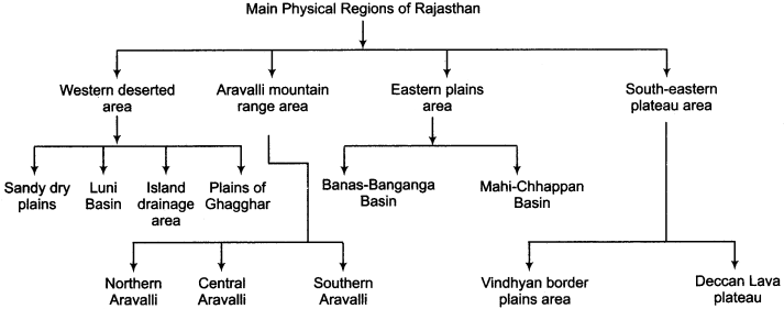
Which are the major physical regions of Rajasthan?
Answer:
The main physical regions of Rajasthan are given below:
Question 3.
Describe the surface characteristics of Southern Aravalli region.
Answer:
The surface characteristics of southern Aravalli region are given below:
- The highest peaks of Aravalli are found in this region.
- It is the origin place of the rivers that flow towards the East.
- The rocks of Schist, Gneiss, dolomite and quartz are found here.
- The zig – zag part of eastern Sirohi district is also called as Bhabar region.
- Evergreen forests are found in this part of Aravalli Range.
- This part of Aravalli receives the maximum rainfall.
- The Passes named Desuri ki Nal, Sadri ki Nal, Hathinal and Somdev Hathiguda are situated in the southern part of Aravalli.
Question 4.
Describe the extension of Eastern plains of Rajasthan.
Answer:
This physical part of Rajasthan lies between the Aravalli mountain range and South Eastern plateau area. It is extended in 23.9 per cent of surface area of Rajasthan. It was formed by the rivers Banas, Mahi and Chambal and their tributaries. This physical part is extended in the districts of Bharatpur, Alwar, Sawai Madhopur, Karauli, Jaipur, Tonk, Bhilwara, Chittorgarh, Dungarpur and some part of Banswara.
Question 5.
Explain the Bay of Bengal drainage system of Rajasthan.
Answer:
Most of the rivers flowing in the eastern plains and southern plateau in Rajasthan drain into the Bay of Bengal and thus form a part of the drainage system of Bay of Bengal. The main Rivers of this system are Chambal, Banas, Banganga, Parvati and Kali Sindh. The origin of River Chambal is Janapav Hills in the Mau district of Madhya Pradesh. This rivers finally joins the river Yamuna at Etawah in Uttar Pradesh.
Banas River originates in the hills of Khamnaur and finally joins the River Chambal at a place called Rameshwar in Sawai Madhopur. Banganga originates in the Hills of Bairath and finally joins River Chambal. The River Parvati originates in the Vindhyan mountains and flows through the district of Baran and finally merges into Chambal at a place called Pali.
Question 6.
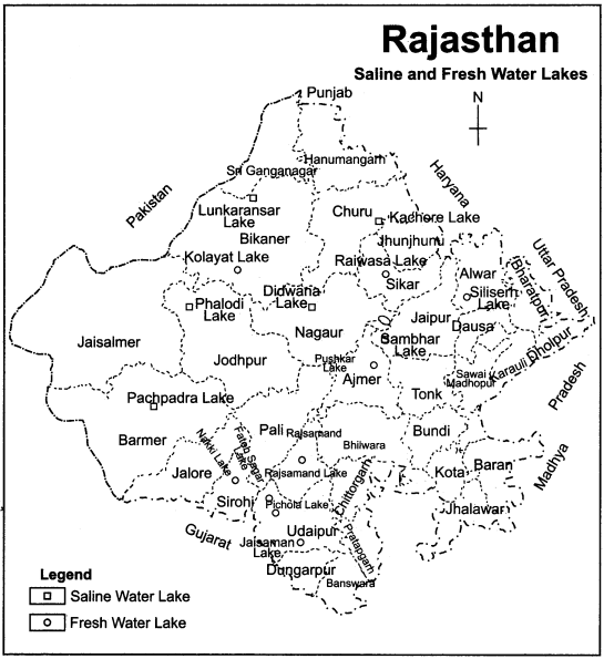
Name the saline – water lakes of Rajasthan.
Answer:
There are many saline – water lakes in Rajasthan out of which Sambhar (Jaipur), Didwana (Nagaur), Pachpadra (Barmer), Lunkaransar (Bikaner), Kuchaman (Nagaur), Phalodi (Jodhpur), Kavod (Jaisalmer), Chhapar Tal (Churu), Degana etc. are famous. The Lake Sambhar is the largest saline-water lake of Rajasthan which is extended in an area of 145 square km in Jaipur. Its length and breadth is 32 km and 12 km respectively.
RBSE Class 11 Indian Geography Chapter 12 Essay Type Questions
Question 1.
In how many phases was the present Rajasthan formed from Rajputana? Explain with the help of a table.
Answer:
The process of forming present Rajasthan from Rajputana was completed in seven phases. The process was started on 17th March, 1948 and it was completed on 1st November, 1956. It took a long period of seven years to complete this. The process is shown in the table given below:
| Phase | Date | Name of Sangh | Estates included |
| First | 17 – 3 – 48. | Matsya Sangh | Alwar, Bharatpur, Dholpur, Karauli. |
| Second | 25 – 3 – 48 | Rajasthan Sangh | Banswara, Kushalgarh, Bundi, Dungarpur, Jhalawar, Kishangarh. Kota, Pratapgarh, Shahpura and Tonk. |
| Third | 18 – 4 – 48 | Joint Rajasthan Sangh | Rajasthan Sangh + Udaipur. |
| Fourth | 3 – 4 – 49 | Greater Rajasthan Sangh | Joint Rajasthan Sangh + Bikaner, + Jaipur + Jaisalmer + Jodhpur. |
| Fifth | 15 – 5 – 49 | Combined Greater Rajasthan | Greater Rajasthan + Matsya Sangh. |
| Sixth | 26 – 11- 50 | Older Rajasthan + B category state | Combined Greater Rajasthan + Sirohi. |
| Seventh | 1 – 11 – 56 | Rajasthan | Older Rajasthan + Ajmer – Merwara + Abu Tehsil + Sunel + Tappa + Sironj. |
Question 2.
Into how many physical regions has Rajasthan been divided? Explain any one of them in detail.
Answer:
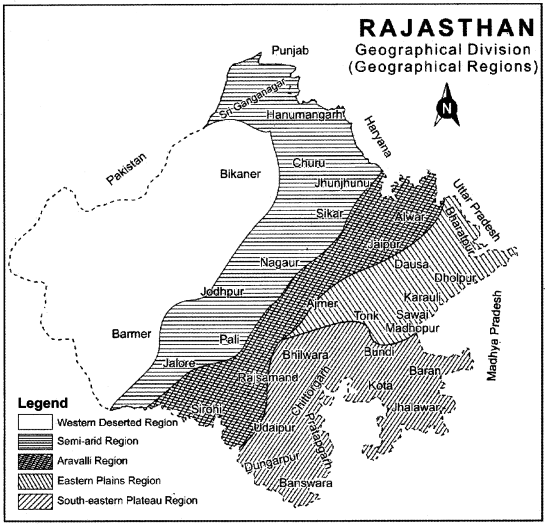
Rajasthan ranks first in India with the viewpoint of area. So, it is natural to have landform variations here. On the basis of land form variations, Rajasthan has been divided into the following physical regions:
- Western Deserted Region
- Aravalli Mountain Region
- Eastern Plains
- South – Eastern Plateau Region
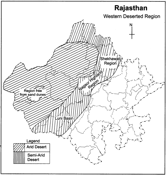
Western Deserted Region:
It is the largest physical region of Rajasthan, which lies from Aravalli mountain range to the west of Rajasthan. Its height is 60 meters to 360 meters from sea level.
Origin of Western Deserted Region:
The formation of desert region in Rajasthan is considered to be done by the deposited silt in Tethys Geocycline. Due to excessive temperature and pressure over these geocyclines of Tethys, it turned into a desert.
Extension of Deserted Area:
The extension of this deserted region of Rajasthan is mainly found in Ganganagar, Hanumangarh, Jhunjhunu, Sikar, Churu, Bikaner, Nagaur, Jodhpur, Jaisalmer, Barmer, Jalore, and Sirohi districts.
Division of Deserted Region of Rajasthan:
On the basis of ground variation, this driest part of Rajasthan has been divided into four parts:
- Sandy Dry plains
- Luni Basin
- Inland Drainage plains
- Plains of Ghagghar.
1. Sandy Dry Plains:
It is a dry deserted plain region which is situated in the west of 25 cm Isohyet of the state. The districts of Jaisalmer, Barmer, Bikaner, Jodhpur, Nagaur and Churu are included in this region.
2. Luni Basin:
This basin is located in the South-west part of Aravalli between the Isohyet line of 25 cm to 50 cm. The extension of this area is in southern Jodhpur, Pali, Jalore and western Sirohi. Pachpadra is the main saline water area of this region.
3. Inland Drainage plains:
It is also known as Shekhavati region. The extension of this semi-dry region is in Jhunjhunu, Sikar, and the Northern part of Nagaur. It is an area of inland drainage system. Most of the Barkhans (sandy dunes) are found in this part. In this region, the rivers and drains disappear after covering a little distance.
4. Plain of Ghaghar:
It is the northern part of desert which is extended in the districts of Ganganagar and Hanumangarh. River Ghagghar is a part of Inland drainage system. The dried-up tributaries and sub rivers of Ghagghar are considered the part of River Saraswati which originated from the Himalayas. Intensive farming is practiced in this region with the help of irrigation obtained from Indira Gandhi and Gang canals. The western deserted region of Rajasthan is shown in the following map:
Question 3.
Explain the physical features of the Aravalli Mountainous Region.
Answer:
Aravalli mountain range, situated in the central part of Rajasthan, is considered to be the oldest mountain range of the world, which has turned into a residual mountain due to the process of denudation. The total length of this mountain range is 692 km, out of which the length of 550 km is found in Rajasthan.
The Extension of Aravalli Mountain Range:
It is extended mainly in the districts of Sirohi, Udaipur, Rajsamand, Ajmer, Jaipur, Dausa, Alwar, Sikar and Jhunjhunu. It is in a series from Sirohi to Khetari, and after that, it is spread up till Delhi in the form of small hills. Divisions of Aravalli: It has been divided into three areas:
- Northern Aravalli
- Central or middle Aravalli
- Southern Aravalli.
1. Northern Aravalli:
It is the northern – most part of Aravalli mountain range which is extended from Jaipur to Khetari. It is mainly extended in the districts of Dausa, Alwar, Sikar, and Jhunjhunu. The hills of Toravati, Shekhawati, Jaipur and Alwar are included in this region of Aravalli. The average height of these hills is from 450 meters to 700 meters. The highest mountain peak of this part is Raghunathgarh (1055 m).
2. Central or Middle Aravalli:
This part of Aravalli is spread from Jaipur to Ajmer. Mountain range of this part of Aravalli is in alternate series. The important peak of this part is Taragarh which is 885 meters high. The river Luni orginates in this part of Aravalli.
3. Southern Aravalli:
This part of Aravalli is extended from Ajmer to Abu. The peaks in this part have the highest height. The highest peak of Aravalli, Guru Shikhar (1722 meters), is situated in this part. Other important peaks are Achalgarh, Delwara, Kumbhalgarh, etc. which are also situated in this part of Aravalli. The plateau of Bhorath lies between Kumbhalgarh. (North Udaipur) and Gogunda which is the origin point of the rivers flowing towards the east.
Question 4.
Describe the drainage system of Rajasthan.
Answer:
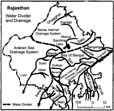
Due to its vast geographical area, Rajasthan also shows variations in the drainage system. The Aravalli Mountain range situated in the middle of Rajasthan divides the drainage system of Rajasthan into two parts. This water divider line extends to the south of Sambhar lake along the Aravalli range. The different rivers originate from two sides of this water divider. The drainage system of Rajasthan has been divided into three parts on the basis of rivers flowing in Rajasthan:
- The drainage system of Bay of Bengal.
- The drainage system of Arabian Sea.
- Inland drainage system.
1. The Drainage System of Bay of Bengal:
Rivers that drain into Bay of Bengal are:
(a) Chambal:
The river Chambal originates from Janapava hill in Madhya Pradesh and finally joins river Yamuna at Etavah in Uttar Pradesh. It is an important river of this system. The major tributaries of Chambal are Banas, Parvati, Kali Sindh etc.
(b) Banas:
It originates from the Khamnor hill of Bhorath plateau and finally joins the river Chambal at Rameshwar in Sawai Madhopur district. Its major tributaries are Berach, Kothari, Khari, Mainal, Bandi, Mansi, Dhundh and Morale.
(c) Banganga:
It originates from Viratnagar of Jaipur and joins river Chambal.
(d) Parvati:
It originates from Vindhyan range, flows in Baran district and merges into Chambal at a place called Pali.
(e) Kali Sindh:
It originates from Vindhyan mountains, flows in Jhalawar and then ends into River Chambal. Parvan is its tributary.
2. Drainage System of Arabian Sea:
(a) Luni:
It originates from the Naga hills of Ajmer and falls into Rann of Kutch. Water of this river is fresh up till Balotara and after this it becomes saline. The chief tributaries of Luni are Jojari, Sukri, Javai and Bandi.
(b) Mahi:
The river Mahi originates from Amjhor in Madhya Pradesh. It flows in the districts of Dungarpur and Banswara and at last it drains into the Bay of Kambhat. Mahi and its tributaries Som and Jakham rivers form the Triveni confluence in Veneshwar Dham. This Dham is a holy piligrimage for the tribal community of Rajasthan. A dam named Mahi Bajaj Sagar has been constructed on the river Mahi in Banswara.
(c) Sabarmati:
The river Sabarmati originates from the western hills of Udaipur. It flows for only 44 km in the state of Rajasthan and flows in the Bay of Khambhat in Gujarat.
3. Inland Drainage System:
There are many small rivers in Rajasthan which cover a little distance and then disappear into the sand. Rivers like Kantali, Sabi, Kankani, Ghagghar etc. are the important rivers of inland drainage system. Sometimes, these rivers overflow and cause floods, when it is heavy rainfall.
Map Based Questions
Question 1.
Show the following on the outline of map of Rajasthan:
- Tropic of Cancer
- Aravalli Mountain Range
- Neighboring states
- International border.
Answer:
Question 2.
Show the physical division of Rajasthan on the map.
Answer:
The physical divisions of Rajasthan have been shown in the following map:
Question 3.
Show the water divider and important rivers of Rajasthan on the map.
Answer:
RBSE Class 11 Indian Geography Chapter 12 Other Important Questions
RBSE Class 11 Indian Geography Chapter 12 Multiple Choice Type Questions
Question 1.
Gilunda civilisation is situated at:
(a) Barmer
(b) Sikar
(c) Udaipur
(d) Ganganagar
Answer:
(c) Udaipur
Question 2.
Kalibanga civilisation is situated at:
(a) Udaipur
(b) Ganganagar
(c) Barmer
(d) Sikar
Answer:
(b) Ganganagar
Question 3.
Which of the following was called as Kurukshetra?
(a) Jodhpur
(b) Abu
(c) Alwar
(d) Bikaner
Answer:
(c) Alwar
Question 4.
Dhundhad Region was the name of:
(a) Jodhpur – Pali
(b) Bundi – Kota
(c) Bikaner – Jodhpur
(d) Jaipur – Tonk
Answer:
(d) Jaipur – Tonk
Question 5.
By which name was Rajasthan known during the British Period?
(a) Rajputana
(b) Merwara
(c) Raithan
(d) Rajasthan
Answer:
(a) Rajputana
Question 6.
How many Panchayat Committees are there in Rajasthan?
(a) 290
(b) 292
(c) 295
(d) 300
Answer:
(c) 295
Question 7.
The border line between Rajasthan and Pakistan is called:
(a) Me Mahon line
(b) Radcliffe line
(c) Durand line
(d) Pyrenees line
Answer:
(b) Radcliffe line
Question 8.
The length of Aravalli in Rajasthan is:
(a) 450 km
(b) 550 km
(c) 650 km
(d) 750 km
Answer:
(b) 550 km
Question 9.
The highest peak of Rajasthan is found in which division of Aravalli?
(a) Northern division
(b) Central division
(c) Southern division
(d) None of the above
Answer:
(c) Southern division
Question 10.
The origin of River Banas is:
(a) In Bairath
(b) In Hills of Khamnor
(c) In Janapav
(d) In Hills of Naga
Answer:
(b) In Hills of Khamnor
Matching Type Questions
Question A.
Match Column A with Column B:
| Column A | Column B |
| (i) Ganeshwar | (a) Bikaner – Jodhpur |
| (ii) Tilwara | (b) Alwar – Jaipur |
| (iii) Bairath | (c) Barmer |
| (iv) Jangal | (d) Dungarpur – Banswara |
| (v) Bansrar | (e) Sikar |
Answers:
- (e)
- (c)
- (b)
- (a)
- (d)
Question B.
Match Column A with Column B:
| Column A (Country) | Column B (Size in context to Rajasthan) |
| (i) Great Britain | (a) Little bit smaller |
| (ii) Sri Lanka | (b) One and a half times smaller |
| (iii) Israel | (c) Five times smaller |
| (iv) Japan | (d) Seventeen times smaller |
Answers:
- (b)
- (c)
- (d)
- (a)
Question C.
Match the rivers given in Column A with their origin place given in Column B:
| Column A (River) | Column B (Place of Origin) |
| (i) Chambal | (a) Hills of Goerunda |
| (ii) Luni | (b) Hills of Sadri |
| (iii) Sabarmati | (c) Hills of Naga |
| (iv) Jakham | (d) Hills of Janapav |
| (v) Berach | (e) Aravalli mountain range in Kotari Tehsil |
Answers:
- (d)
- (c)
- (e)
- (b)
- (a)
Question D.
Match Column A with Column B:
| Column A (Lake) | Column B (Related city) |
| (i) Jaisamand | (a) Rajsamand |
| (ii) Rajsamand | (b) Mount Abu (Sirohi) |
| (iii) Pushkar | (c) Alwar |
| (iv) Siliserh | (d) Ajmer |
| (v) Nakki | (e) Udaipur |
Answers:
- (e)
- (a)
- (d)
- (c)
- (b)
RBSE Class 11 Indian Geography Chapter 12 Very Short Answer Type Questions
Question 1.
Name the rivers which flowed in Rajasthan in ancient time.
Answer:
The Rivers Saraswati and Drashdhwati flowed in Rajasthan in ancient time.
Question 2.
Which area was called as Gurjaratra Region?
Answer:
In Rajasthan, the nearby region of Jodhpur and Pali which were the parts of Marwar was jointly called Gurjaratra.
Question 3.
By what name was Udaipur and its neighbouring area called before independence?
Answer:
Udaipur and its neighbouring area was called as Shiva or Bhedpat and Mewar before India got independence.
Question 4.
At the time of independence, into how many administrative units was Rajasthan divided?
Answer:
At the time of independence, there were 19 estates, 3 chiefships and one union terriory named Ajmer – Merwara in Rajasthan.
Question 5.
When was Matsya Sangh formed?
Answer:
Matsya Sangh was formed on 17th March, 1948.
Question 6.
Which estates were included in the Rajasthan Sangh?
Answer:
The estates of Banswara, Kushalgarh, Bundi, Dungarpur, Kishangarh, Kota, Pratapgarh, Shahpura and Tonk were unified and included in the Rajasthan Sangh.
Question 7.
When and how was the Joint State of Rajasthan formed?
Answer:
The formation of Joint Rajasthan was done on 18th April, 1948, by merging the estate of Udaipur in older Rajasthan Sangh.
Question 8.
When and how was Greater Rajasthan formed?
Answer:
Greater Rajasthan was formed on 30th March, 1949, by merging the estates of Bikaner, Jaipur, Jaisalmer and Jodhpur in Joint Rajasthan.
Question 9.
How and when was Joint Greater Rajasthan established?
Answer:
The Joint Greater Rajasthan was formed on May 15, 1949, by merging Matsya Sangh into Greater Rajasthan Sangh.
Question 10.
When was Rajasthan declared as a state of A category?
Answer:
Rajasthan was declared as a state of A category on November 1, 1956.
Question 11.
Into how many administrative units has Rajasthan been divided at present?
Answer:
With the viewpoint of administration, Rajasthan has been divided into seven divisions, 33 districts, 9 sub – districts, 314 tehsils, 295 panchayat samitis, 222 nagar palikas and 990 village panchayats.
Question 12.
Name the states which form the border of Rajasthan.
Answer:
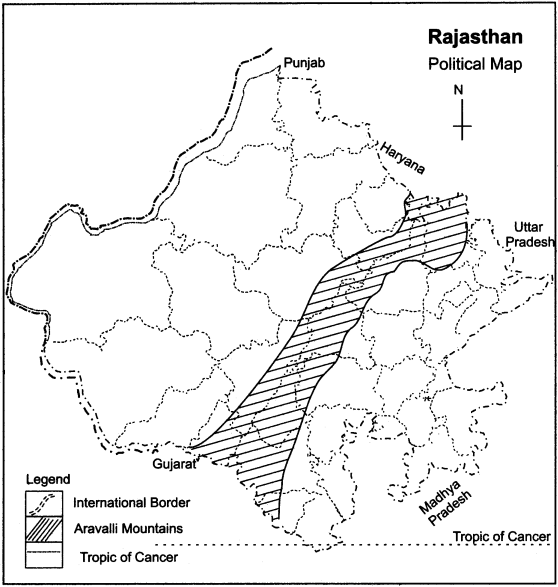
The border of Rajasthan is formed by Punjab in North, Haryana in North – East, Uttar Pradesh in East, Madhya Pradesh in South – East and by Gujarat in South – West, while its international border is formed by Pakistan in the west.
Question 13.
What is the expanse of Rajasthan from North to South?
Answer:
The expanse of Rajasthan from North to South is 826 km.
Question 14.
What is the expanse of Rajasthan from East to West?
Answer:
The expanse of Rajasthan from East to West is 869 km.
Question 15.
In what form is the evidence of Tethys Ocean found even today?
Answer:
The salt water lakes like Sambhar, Didwana, Pachpadra, Lunkaransar, etc. in Rajasthan are the evidence of remains of Tethys Ocean in Rajasthan.
Question 16.
WThich is the water divider of Rajasthan?
Answer:
Aravalli Mountain Range is considered as the water divider of Rajasthan.
Question 17.
Why is the landscape of desert changing?
Answer:
Due to human effects and the development of Indira Gandhi canal and Gang canal, facilities of irrigation have been provided in the deserts of Rajasthan, and so the landscape of desert is changing.
Question 18.
How many types of sand dunes are there in Rajasthan?
Answer:
There are three types of sandy dunes found in Rajasthan:
- Transversal
- Longitudinal
- Barkhan
Question 19.
What is meant by transversal sand dunes?
Answer:
The sand dunes which are formed in the mound parallel to the direction of flow of wind are Called transversal sand dunes.
Question 20.
What is meant by longitudinal sand dunes?
Answer:
The sandy mounds which have developed perpendicular to the direction of flow of wind are called longitudinal sand dunes.
Question 21.
What is meant by the term Rann?
Answer:
The shallow area of saline water found in the sandy dry regions is called Rann.
Question 22.
Which rivers provide assistance in the formation of Luni Basin?
Answer:
The Rivers Luni, Lilari, Sukri, Jawai, and Bandi have provided assistance in formation of Luni Basin.
Question 23.
Which lakes are found in the inland drainage system?
Answer:
The main lakes of salt water found in the inland drainage system are Sambhar, Didwana, Kuchaman, Sujangarh, Tal Chhapar, and Parihara.
Question 24.
Describe the extension of Aravalli Mountain Range in Rajasthan.
Answer:
The extension of Aravalli mountain range is from Khetari of Jhunjhunu to the village of Khedbrahma located on the border of Gujarat.
Question 25.
Name the districts through the Aravalli mountain range passes.
Answer:
The Aravalli mountain range passes through the districts of Sirohi, Udaipur, Rajsamand, Ajmer, Jaipur, Dausa, Alwar, Sikar and Jhunjhunu.
Question 26.
Where is the Plateau of Bhorath situated?
Answer:
The Plateau of Bhorath is situated between Kumbhalgarh and Gogunda in the South of Udaipur.
Question 27.
In which district is the extension of Northern Aravalli found?
Answer:
The extension of Northern Aravalli is found mainly in Jaipur, Dausa, Alwar, Sikar and Jhunjhunu districts.
Question 28.
What is the Plain of Chhappan?
Answer:
There are fifty – six villages between Banswara and Chittorgarth. This group of villages is called the Plain of Chhappan.
Question 29.
Where is the Plain of Malpura found?
Answer:
The Northern part of the plains formed by River Banas and its tributaries is called the Plain of Malpura – Karauli.
Question 30
What do you understand by the term Walra cultivation.
Answer:
The shifting agriculture practiced by the tribes belonging to Dungarpur and Banswara districts in south Rajasthan is called Walra cultivation.
Question 31.
Describe the extension of the Plateau of Hadoti.
Answer:
The Plateau of Hadoti is extended in the districts of Kota, Bundi, Baran, Jhalawar, and eastern area of Chittorgarh. All these regions are situated in South – Eastern Rajasthan.
Question 32.
How are the Triangular Alluvium Plains formed?
Answer:
The formation of Triangular Alluvium Plains has been done by River Chambal and its tributaries Kali Sindh and Parvati flowing in the area of Lava-Plateau of Deccan.
Question 33.
Where does the River Parvati flow?
Answer:
Starting from Vidhyayan mountain range in Madhya Pradesh, Parvati river flows in the district of Baran and drains into the Chambal at Pali.
Question 34.
What is the meant by inland drainage system?
Answer:
Those seasonal rivers of Rajasthan which do not drain into the sea, but after flowing in some area, they disappear in the desert area or merge into internal lake is called the inland drainage system.
Question 35.
Name the fresh water lakes of Rajasthan.
Answer:
Jaisamand, Rajsamand, Pushkar, Siliserh, Ramgarh, Kolayat, Nakki, Kaylana, Ana Sagar, Fateh Sagar and Pichola are the fresh water lakes of Rajasthan.
Question 36.
Name the important estates of Rajasthan in the British period.
Answer:
The important estates of Rajasthan in the British period were Jaipur – Ajmer, Marwar, Mewar, Kota, Bundi, Bharatpur etc.
RBSE Class 11 Indian Geography Chapter 12 Short Answer Type Questions (SA-I)
Question 1.
Rajasthan is the shelter home of several civilizations. How? Explain.
Or
Rajasthan is a home of many civilizations. Explain.
Answer:
Rajasthan has been the centre of the ancient civilizations of the world. These civilizations exhibit their glorious history which provides Rajasthan a unique importance. There were many civilizations in Rajasthan. The remains found in different parts of Rajasthan enchant the glory of ancient civilizations like Tilwara (Barmer), Ahad (Udaipur), Gilund (Udaipur), Kalibanga (Ganganagar) and Ganeshwar. This proves the fact that Rajasthan has been the shelter home of many civilizations.
Question 2.
Rajasthan has a glorious place in India since the beginning. How?
Answer:
Rajasthan is a land of braves and martyrs. This state has protected the Indian pride many times. Citizens of this state have exhibited their capabilities and intelligence by facing adverse and abrupt circumstances. Due to the examples of invincible courage set by the brave men and women of this state, it has occupied a unique place in history.
Question 3.
How did Rajasthan get its name?
Answer:
The name of Rajasthan is a result of a long process. The Rajputs ruled over this state for a long time period, so the British government called this area by the name of Rajputana. It was also famous as Rajwara. The British called the Rajas (emperors), as Roy, due to this, it was named Roy by them, and with the course of time, Roy was later converted into Rajasthan.
Question 4.
Explain the physical characteristics of Rajasthan.
Answer:
The physical characteristics of Rajasthan have been given as below:
- This is the remains of Tethys geosyncline in the form of desert, situated in the northern and western part of Rajasthan.
- The Aravalli mountain range and southern plateau region are areas of ancient Gondwanaland.
- The Aravalli mountain range present here is the oldest mountain range of the world.
- The result of effects of geological changes, denudation and drainage system is seen in many forms in Rajasthan.
Question 5.
The desert was considered a curse for Rajasthan some years ago but now it is considered to be a boon for the state. How?
Answer:
Due to unfavourable conditions like high atmospheric temperature, less rainfall, transportation of sandy dunes and lack of moisture, the desert of Rajasthan was unfertile and barren and so it was considered a curse for the state. But after the discovery of reserves of mineral oil, gas and coal, it became prosperous. And the Indira Gandhi water canal project has made it green. Now, farming and plantation is done in this area, therefore it is now proving to be a boon for the state in the present time.
Question 6.
Write the characteristics the Northern Aravalli mountainous region.
Answer:
The main characteristics of Northern Aravalli mountainous region are:
- The Aravalli is not in a sequential form, but it is in the form of scattered hills.
- The height of peaks of Aravalli in this part is lesser than that of Southern part.
- There are abundant reserves of copper in this part of Aravalli Mountain Range.
Question 7.
How were the Eastern plains of Rajasthan formed?
Or
The Eastern plain of Rajasthan is a gift of rivers flowing here. How?
Answer:
The formation of the plains found in the eastern part of Rajasthan was due to the Rivers Chambal, Banas and their tributaries. The rivers carried the silts along with their flow and deposited it in this region. Due to the silt deposition by the rivers Chambal, Banas and their tributaries, this plain came into existence. It is fertile due to the deposition of kaamp arid alluvial soil.
Question 8.
How was the South – eastern plateau formed?
Answer:
The south – eastern plateau region of Rajasthan is a result of the tectonic process which took place in ancient times. The black – soil found in this region proves that it is made of Lava and the plateau is the: result of volcanic eruption.
Question 9.
Write the characteristics of plateau area of Rajasthan.
Answer:
Following are the characteristics of plateau area of Rajasthan:
- This plateau region is a part of ancient Gondwana land.
- A mixture of lava – based rocks and Vindhyan rocks is found in this area.
- The rivers have cut this area with their water flow.
- Kota stone is found in the form of flaky rocks in this plateau region, which has gained name and fame in the world.
- The slope of this region is from the South towards the North – East.
Question 10.
What is meant by drainage system? What are its controlling factors?
Answer:
In geomorphology, drainage systems are the patterns formed by the streams, rivers and lakes in a particular drainage basin. It is also known as river system. The drainage systems are governed by the topography of the land, i.e. whether a particular region is dominated by hard or soft rocks, and the gradient of the land.
Question 11.
What is the importance of salt water lakes in Rajasthan?
Answer:
The salt water lakes are proving themselves useful for the state. They contain saline water, but they are very important:
- Due to the production of salt, they are commercially profitable.
- They provide moisture rich atmosphere to the neighboring areas that makes the soil fertile.
- The salt water lakes provide employment to neighboring people.
- Due to these lakes, a network of roads and routes has been developed.
RBSE Class 11 Indian Geography Chapter 12 Short Answer Type Questions (SA-II)
Question 1.
Various regions of Rajasthan were named on regional basis, explain.
Or
Regions of Rajasthan were named according to their specific qualities. How?
Or
Rajasthan is a unitary form of zones of different names. How?
Answer:
Rajasthan is also known for its different regional names along with the variation in its land. In ancient and medieval period, different parts Rajasthan were famous for their specific regional identity. For example, Ganganagar and its neighboring area was known as Yauddheya. The neighbouring area of Nagaur was famous as Ahichchatrapur, Jodhpur – Pali area was called Gujratra, Jaisalmer and its related areas were famous by the name of Valla or Dungal or Maad.
In the same way, Jalore and its neighbouring region was named Swarnagiri, Abu and related area as Chandravati, Udaipur and related parts of Chittorgarh were famous as Shiv or Medpat or Mewar. The area of Dungarpur and Banswara was called Vagar, the region of Alwar was called Kuru, Bharatpur, Dholpur.
Karauli region was called Shoorsen or Brijbhumi. The area of Kota – Bundi was Known as Hadoti, Alwar – Jaipur area was known as Bairath estate, Bikaner and Jodhpur area was called Jangal, Sambhar and neighbouring area was famous as Shakambhari and the area of Dausa and Tonk was known as Dhundhar.
Question 2.
With context to India, describe the location of Rajasthan.
Or
With reference to India, describe the locational position of Rajasthan.
Answer:
Rajasthan is the largest state of India in context of area. The Tropic of Cancer passes through the Banswara district situated in southern Rajasthan. There is Punjab in its North, Haryana in its North – East, Uttar Pradesh in its East, Madhya Pradesh in its South – east and Gujarat in the South – West of Rajasthan. There is an international border line of length 1070 km between Rajasthan and Pakistan which is known as Radcliffe border line.
The districts of Ganganagar, Bikaner, Jaisalmer and Barmer are the frontline districts. The state is kite – shaped. Its citizens have always showed their valour and understanding even in unfavourable conditions. The people of Rajasthan have always set an example of their courage, bravery and sacrifice in the history. Hence, it has occupied a glorious place in India.
Question 3.
Describe the characteristics of deserted area of Rajasthan.
Or
The condition of desert in Rajasthan shows singularity. How? Explain.
Answer:
The characteristics of desert spread in the western part of Rajasthan are given as below:
- It is considered as the remains of Tethys geosyncline.
- In the desert area of Rajasthan, transportation of sand dunes is seen.
- The transversal, longitudinal and Barkhan dunes are found in this region.
- There are many salt water lakes in this area.
- The conditions of high temperature, less rainfall and lack of vegetation are seen here.
- Most of the vegetation found here is in the form of grass or thorny shrubs.
- The inland drainage system and bunches of rivers are seen here.
- The extension of sandy soil is found in this area.
Question 4.
Describe the relief form found in Rajasthan.
Or
What type of relief based diversity is seen in Rajasthan? Explain.
Answer:
Due to vast area of Rajasthan, there is variation based on relief found here. There are hills, plateaus, plains, deserts here, which is due to topological variation. On the basis of these variations, Rajasthan has been divided into the following divisions:
1. Areas of surplus height:
The areas whose height is more than 600 meters are called the areas of surplus height. Such types of areas are found in the Aravalli mountain range in Rajasthan. The highest region is present in Rajasthan in the form of Guru Shikhar. Besides it, on the banks of river Chambal, such condition is seen.
2. Areas with medium height:
The areas whose height varies from 150 to 600 meters are called the areas of medium height. The districts of Ganganagar, Hanumangarh, Churu, Jhunjhunu, Bikaner, Nagaur, most of the parts of Jaisalmer, Jodhpur, most part of Barmer, Sirohi, Dungarpur, Alwar, Bharatpur, Dholpur, Karauli, Sawai Madhopur, Dausa, Tonk, Bundi – Kota, Jaipur, Pali, Rajsamand, Bhilwara, Udaipur, Baran, Jhalawar, Chittorgarh, Pratapgarh are included in this division.
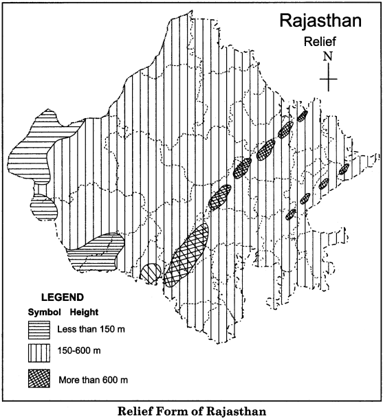
3. Areas with less height:
The areas whose height is less than 150 meters are included in this division. The western part of district of Jaisalmer, South – western part of Barmer and Jalore have been included in this division.
Question 5.
Describe the importance of plains found in Rajasthan.
Or
How are the plains useful and important for the state of Rajasthan? Explain briefly.
Answer:
The usefulness of plains region of Rajasthan has been described in the points given below:
- This plain is made of alluvial soil, So it is very fertile.
- The new layer of soil is laid every year, therefore the soil continuously gets renewed.
- There is a network of rivers seen here, so the obtained water is used for irrigation, water transportation, generating hydro – electricity and industries.
- The plains part in Rajasthan is even and smooth, so it is easy to dig wells and canals. Cheap and abundant means of irrigation are available here.
- It is one of major wheat producing areas of India.
- Approximately, 39 per cent population of the state resides in the plains of Rajasthan.
- The plains are even and smooth, hence a dense network of all types of modes of transportation is seen here.
- Most of the important cities, trade and industrial centers are situated in this area.
- Sufficient goods of daily importance are available here.
- The facilities of trade and commerce are available in this region.
- Industrial development is seen all around due to the available facilities.
- There are many tourist and picnic spots here. ,
Question 6.
Describe the importance of south-western plateau region of Rajasthan.
Or
What is the utility of south-western plateau area for Rajasthan?
Answer:
Following are the points importance of South-Western plateau region of Rajasthan:
- It is ail ancient, hard and strong part of Gondwanaland and hence it is a fixed ground part.
- Due to being a fixed ground part, it is safe from natural disasters like earthquakes, volcanoes etc.
- It is made of ancient rock system so it in rich in viewpoint of minerals.
- There are precious forests of Sal, Teak and Rosewood.
Question 7.
Explain the water divider line of Rajasthan.
Or
The drainage system of Rajasthan has been controlled by the water divider line. How? Explain it.
Answer:
The drainage system of Rajasthan is governed by the water divider line found in the central part of the state. This water divider line, along with the axis of Aravalli in the North, proceeds to the south of Sambhar Lake, and from here, it passes through a few kilometres away from Beawer, Deogarh, Kumbhalgarh and Haladighati of Udaipur and moves towards Udai Sagar.
Then it proceeds ahead and flowing in Sadri and Chhoti Sadri in South – east, and goes to Pratapgarh. The rivers of south-western side of this water divide drain into the Arabian Sea. Luni, western Banas, Sabarmati and Mahi are the main rivers among them. In the eastern part of the water divider, river Banas and its tributaries merge into Chambal.
Banganga also joins the river Chambal. From here, water of Banas and Chambal flows into Yamuna and Ganga rivers and finally drains into the Bay of Bengal. In this way, water divider divides the drainage system of Rajasthan into two parts, which are the drainage system of Bay of Bengal and the drainage system of Arabian Sea.
Question 8.
Compare’the drainage systems of Bay of Bengal and Arabian Sea.
Or
How is the drainage system of Arabian Sea different from the drainage system of Bay of Bengal?
Answer:
The difference between the two drainage systems found in the state of Rajasthan can be expressed as follows:
| Basis of Comparison | Arabian Sea drainage system | Bay of Bengal drainage system |
| Number of Rivers | There is less number of rivers in this drainage system. | There is more number of rivers in this drainage system. |
| Drainage Area | There is a less drainage area of the rivers of this system. | There is more drainage area of the rivers of this system. |
| Length | The length of most of rivers of this system is less. | The length of most of the rivers of this system is more. |
| Flow | The flow of all the rivers of this system is seasonal. | The main river Chambal of this system is perennial. |
| Drainage of rivers | The main rivers of this system directly drain into the sea. | The main rivers of this system first join the river Chambal and then fall into Yamuna and at last drain into the Bay of Bengal. |
| Utility | The rivers of this system are less useful. | The rivers of this system make the fertile plains and hence they are very useful. |
Question 9.
Explain the importance of fresh – water lakes in Rajasthan.
Or
What is the utility of fresh – water lakes for Rajasthan ?
Answer:
The fresh water lakes of Rajasthan are very useful due to their sweet and clean water. Their importance can be understood as given below:
- Water of these lakes is supplied for drinking.
- The water of these lakes is used for irrigational purposes.
- Due to their natural beauty, these lakes largely attract the tourists.
- As boating can be done in these lakes, they are proving to be profitable.
- The islands found in these lakes have become places of human settlement.
- These lakes provide a lot of fishery resources for human.
- These lakes are the shelter homes of many sea creatures and hence they promote biodiversity.
RBSE Class 11 Indian Geography Chapter 12 Essay Type Questions
Question 1.
Dividing Rajasthan into topographic regions, explain its Eastern plains.
Or
The Eastern plains of Rajasthan are the gift of many rivers. How? Explain it.
Answer:
Rajasthan is a state of vast geographical area. So, topographic conditions in the state are found to be different. With the viewpoint of relief, Rajasthan has been divided into the following topographical regions:
- Western desert region
- Aravalli mountainous region
- Eastern plains
- South – eastern plateau region
Description of Eastern Plains of Rajasthan:
Origin and formation of these plains has been done by silt carried and deposited by the rivers flowing in Rajasthan.
Extension:
The extension of eastern plains of Rajasthan is in 23.9 per cent part of total area of Rajasthan. These plains are mainly spread in the districts of Jaipur, Dausa, Bharatpur, Dholpur, Karauli, Sawai Madhopur, Tonk, Ajmer, Bundi, Chittorgarh, Pratapgarh and Banswara. It is an even plains region which is very fertile due to the deposition of alluvial soil.
This eastern plain region of Rajasthan has been divided into the following parts:
1. Basin of Banas – Banganga:
This plain formed by the rivers Banas and its tributaries is known as the plain of Me war in southern Rajasthan and as plains of Malpura – Karauli in the North. The main tributaries of river Banas are Berach, Khari, Mansi, Morale and Banganga. The slope of this plain is towards the east and north-east. The solo hills become hillock type at the height. The average height of this plain is 280 to 500 meters from sea level.
2. Central Mahi – Chhappan Basin:
This plain is spread in the south-east part of Udaipur, Dungarpur, Banswara and southern region of Chittorgarh. It covers an area of 7056 square kilometres. The average height of this plain is 200 meters to 400 meters. It is called Chhappan in the local language of Salumbar-Sarada region and in Dungarpur and Banswara region it is called Bagar. Due to excessive number of rivers, it is also called the region of 100 islands.
Som, Jakham, Kagadar, Jhamari etc. are the main tributaries of river Mahi. The tribes of Bhil and Garasiya practice shifting agriculture that is called as walra cultivation in local language. Besides these two major regions, Chambal river has also formed a plain region called in the form of Chambal basin. This plain area is mainly extended in the districts of Kota, Dholpur, Karauli, Sawai Madhopur etc. This is a major and important fertile plain region of north-eastern Rajasthan.
Question 2.
Dividing Rajasthan into physical regions, and explain the South-Eastern plateau area.
Or
The South – Eastern plateau region of Rajasthan is the most ancient landform. Explain.
Answer:
Rqjasthan is the largest state in India with the viewpoint of area. There are topographical variations due to its large size. With the viewpoint of relief, Rajasthan has been divided into the following physical regions:
- Western desert region
- Aravalli mountainous region
- Eastern plains
- South – Eastern plateau region
Description of South – Eastern plateau region:
Origin:
This part of Rajasthan is a region of ancient Gondwanaland which originated by the process of tectonic reaction and was formed by the lava coming out from volcanic eruption, that’s why its soil is black in colour.
Extension:
The physical region of Rajasthan is extended in the south-eastern part. 9 per cent of total area of Rajasthan has been covered by this plateau region. Mainly, districts of Kota, Bundi, Jhalawar and Chittorgarh are included in it. The lava mixed rocks and Vindhyan rocks are found here. The average height of this region from sea level is 500 meters. The rivers like Chambal, Parvati, Kali Sindh and Parvan flow in this plateau region.
On the basis of structure of rocks, this region of Rajasthan has been divided into two parts:
- Vindhyan Scarpland.
- Lava plateau of deccan.
1. Vindhyan Scarpland:
This area is mainly formed of sandy and limestone rocks. The average height of this area varies from 350 to 550 meters from sea level. The mouth of the Scarp land is sequentially towards the south – east and eastern direction between the rivers Banas and Chambal. This part has extended into Sawai Madhopur, Karauli and Dholpur along the side of Chambal.
2. Lava plateau of Deccan:
It is broad and elevated rocky area of south eastern Rajasthan. It is made of sandy and limestone rocks. Its eastern and southern part is covered with lava. The fertile black soil is found here which is very useful for the cultivation of cotton and groundnuts. The river Chambal and its tributaries Kali Sindh and Parvati have made this a triangular alluvial plain. The deposits of rocks are seen in this area. Kota – stone that is found in this region has gained world-wide name and fame and is renowned in the entire world for its superb quality.
Question 3.
Describe the lakes found in the state of Rajasthan.
Answer:
There are two types of lakes found in Rajasthan:
- Saline water lakes
- Fresh water lakes
1. Lakes of salt water:
The distribution of this type of lakes is found in the western desert area and the inland drainage system areas. All these lakes are natural and shallow.
(a) Sambhar Lake:
It is the largest salt water lake of India. It is situated in the districts of Jaipur, Ajmer and Nagaur. This lake, included in the district of Jaipur, covers an area of 145 square km. The length and breadth of this lake is 32 km and 12 km respectively. The Hindustan Salt Limited company produces salt from this lake. It is an enterprise of government of India.
(b) Didwana Lake:
It is situated in the city of Didwana in Nagaur district. The length of this lake is 4 km.
(c) Pachpadra Lake:
It lies in the town of Pachpadra in the district of Barmer. It covers an area of 25 square km.
(d) Lunkaransar Lake:
It is situated in Lunkarasar town of Bikaner. Besides these, some other salt water lakes are Phalodi (Jodhpur), Kavod (Jaisalmer), Kuchaman (Nagaur), Tal Chhapar (Churu) etc.
2. Lakes of fresh water:
The lakes of fresh water are used for obtaining drinking water and the facility of irrigation. The fresh water lakes in Rajasthan are Jaisamand (Udaipur), Rajsamand (Rajsamand), Pushkar (Ajmer), Siliserh (Alwar), Ramgarh (Jaipur), Kolayat (Bikaner), Nakki (Mount Abu), Kaylana (Jodhpur), Pichola, Ana Sagar etc. The description of some important lakes is given below:
(a) Jaisamand Lake:
This lake was built in 1685-1691 by constructing a dam on the river Gomati by Rana Jai Singh. It is situated in the district of Udaipur. The length and width of this lake is 15 km and 2.8 km respectively. It covers a total area of 55 square km. It is also known as Dhebar Lake. .
(b) Rajsamand Lake:
It was built by Maharana Raj Singh in 1662. It is situated near the Kankroli railway station This lake is around 6.5 km long and 3 km wide.
(c) Pichola Lake:
In the reign of Rana Lakha, it was built by a chieftain. It is situated in a village named Pichola in the western part of Udaipur. Its breadth is 7 km.
(d) Ana Sagar Lake:
It is situated between two hills in Ajmer. It is an artificial and a beautiful lake. It was built by Annaji in 1137.
(e) Siliserh Lake:
It is situated in the district of Alwar and covers an area of 10 square kiliometers.
(f) Kolayat Lake:
It is situated at a distance of 48 km to the south-west of Bikaner. There was Kapil Muni’s Hermitage here.
(g) Pushkar Lake:
It is situated at a distance of 11 km from Ajmer at a place named Pushkar. The most ancient temple of Brahmaji is situated here. Ghats have been formed around this lake.
The important lakes of Rajasthan are shown in the map given below: