Rajasthan Board RBSE Class 11 Indian Geography Chapter 4 India: Structure, Relief and Physiographic Regions
RBSE Class 11 Indian Geography Chapter 4 Text Book Questions
RBSE Class 11 Indian Geography Chapter 4 Multiple Choice Questions
Question 1.
The physiographic region between the rivers of Sutlej and Kali is:
(a) Himachal Himalayas
(b) Sub – Himalayas
(c) Kumaon Himalayas
(d) Nepal Himalayas
Answer:
(c) Kumaon Himalayas
Question 2.
Wheeler island is a:
(a) Distant island
(b) Alluvial island
(c) Hilly island
(d) Coral island
Answer:
(b) Alluvial island
Question 3.
The place where the natural renewal of soil takes place every year is:
(a) Bhabar region
(b) Terai region
(c) Bangar region
(d) Khadar region
Answer:
(d) Khadar region
RBSE Class 11 Indian Geography Chapter 4 Very Short Answer Type Questions
Question 1.
What is Talli?
Answer:
Talli is a lowland found in deserted areas among the sand dunes or the heaps of sand.
Question 2.
Where are Margs found?
Answer:
Margs are the grasslands which are found mostly in the Smaller Himalayas.
Question 3.
What is called as the Konkan Coast?
Answer:
The Northern part of western coast is called the Konkan Coast. It is spread from Surat to Goa.
RBSE Class 11 Indian Geography Chapter 4 Short Answer Type Questions
Question 1.
What is the difference between Talli and Dhandh?
Answer:
The difference between Talli and Dhandh:
| Talli | Dhandh |
| 1. These are formed in the form of lowland found between the sand – dunes. | 1. These are formed in the form of temporary lakes which are formed due to the rainwater getting collected in Tallis. |
| 2. Talli is always a water – less part. | 2. Dhandhs are filled with water. |
Question 2.
Differentiate between Western Ghats and Eastern Ghats.
Answer:
There are several differences between Western Ghats and Eastern Ghats as given below:
| Western Ghats | Eastern Ghats |
| 1. It is situated in the western part of western plateau in India. | 1. It is situated in the eastern part of Southern Plateau of India. |
| 2. The height of this Ghat is more. | 2. The height of this Ghat is less. |
| 3. The northern part of this ghat Was formed by lava and southern part is formed by gneiss, Schist and Charnockite rocks. | 3. This Ghat is formed by gneiss, Schist, Khondalite and Charnockite rocks. |
| 4. It shows the nature of rapid slopes. | 4. It shows the nature of gradual slopes. |
Question 3.
Name the rocky islands of India.
Answer:
The rocky islands in India are found in the coastal part of Western Ghats. The major rocky islands in India are Henry, Canary, Butcher, Elephanta, Pigeon island near Mumbai and Piram and Bhainsala, etc. islands found on the Kathiawar Coast.
RBSE Class 11 Indian Geography Chapter 4 Essay Type Questions
Question 1.
Divide India into physio – graphic regions and explain the Himalayan region.
Answer:
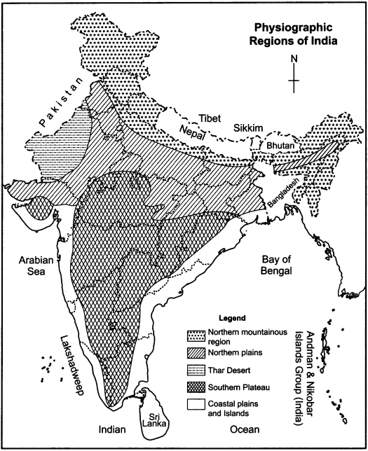
India is a vast country with geographical diversities. Due to these diversities, the geographical differences in land, air and temperature are seen here at large. On the basis of these differences, India can be divided into the following physio – graphic regions:
- Northern Mountainous Region
- Great Plains of Ganga and Yamuna
- Desert region or Thar region
- Southern Plateau (Deccan Plateau)
- Coastal region
- Islands
Location of Himalaya:
The Himalaya mountain region is situated in the northern part of India and it determines the natural boundary of India.
The Himalayas mountain range has formed as a result of the collision between the Indian plate and Eurasian plate which began 50 million years ago and continues even today. Around 225 million years ago, India was a large island situated at the Australian Coast and separated from Asia by the Tethys Ocean. Over 200 million years ago, Gondwanaland split into pieces and Indian Plateau moved towards North – East and collided with Eurasian plate. Due to this collision folded mountain of Himalaya was formed.
Expansion of Himalayas:
This mountain region represents the newest and one of the most folded mountains in the world. The Himalaya form an arch which covers a distance of about 2400 km and varies from 400 km in Kashmir to 250 km in Arunachal Pradesh. The total area which is covered by them is 5 lakh square km. The highest mountain peaks of Himalayas include, Kanchenjunga, Nanga Parbat, Nanda Devi, Makalu, Manaslu, etc.
The Physical Division of Himalayas:
On the basis of structure, position and relief, Himalayas have been divided into:
- Greater Himalayas
- Smaller Himalayas
- Sub – Himalayas
1. Greater Himalayas:
It is the highest and northern-most section of the Himalayan mountain ranges. It extends towards the north – east across northern Pakistan, northern India and Nepal, before it proceeds eastwards across Sikkim state and Bhutan and finally turns towards the north – east across northern Arunachal Pradesh. The highest peaks like Kanchejunga, (8598 m), Makalu (8481 m), Nanga Parbat (8126 m), Annapurna (8078 m), Nanda Devi (7818 m) etc. are found here. The narrow valleys formed by the rivers are also found in this part. To the south – east part of it, many hills like Garo, Khasi, Jayantiya, Patgoi, Naga, Bum and Luslai are found. The major passes in this part are Khaibar, Gomal, Tochi, Bolan etc.
2. Middle Himalaya or Smaller Himalaya:
This part is found in the south of greater Himalayas. It is also known as middle Himalayas. The width of this part is 80 to 100 km and the average height is 3000 m. But at some places, its maximum height is found to be 5000 m. The major mountain ranges in this part are Dhauladhar, Pir Panjal, Nag – Tibba, Mahabharata and Mussoorie etc. There are several beautiful tourist spots in this region. The examples of river capture are also found in this region.
3. Sub Himalayas:
It is a 1600 km long mountain range in India, and is the southernmost range of the Himalayas. It is also known as the outer Himalaya or Shivalik range. It has extended from Potwar basin up to River Kosi. It is also called The Dundava, Churiyan and Muriyan. The regions of Bhabar and Terai are found, in this part. Between the Shivalik range, Dwar and Duns are also found which have formed due to the sand and soil deposited by the rivers.
Regional classification of Himalayas:
The Himalayas are also classified as Himachal Himalaya, Kumaon Himalaya, Nepal Himalaya and Assam Himalaya.
Importance of Himalayas:
Himalaya is also famous as the Parvatraj (king of mountains) and Devbhumi (the land of Gods). The great Sanskrit poet Kalidas has described Himalyas in his literature. The importance of Himalayas can be describe as follows:
- It determines the northern border of India.
- It saves India from the cold winds blowing from North Pole.
- By blocking the southern monsoons, it helps to cause rainfall in India.
- The perennial rivers that originate from the Himalayas are the main source of irrigation in India. They also form the alluvial plains.
- The forests in Himalayan region are very useful in providing raw materials for industry, valuable wood and many herbs.
- The plantation farming of tea, saffron and coffee is practiced in the slopes of the Himalayas.
- There are many beautiful sights, lakes, natural picnic spots and healthy climate is found here.
- There are many religious pilgrimage places in this area.
Question 2.
Classify India into physio – graphic regions and write a short note on the Great plains of India.
Answer:
India is a large country with geographical diversities. Due to these diversities, physio – graphic differences in land, air and temperature are seen here at a large scale. On the basis of these differences, India can be divided into the following physio – graphic regions:
- Northern Mountainous Regions
- Great plains of India
- Thar Desert
- Southern Plateau (Deccan Plateau)
- Coastal region
- Islands.
Description of Great Plains of India:
This region is located between the great Himalayan mountain regions and the peninsular plateau of India. It also known as the Sutlej – Ganges – Brahmaputra plains.
The Origin of the Great Plains:
This great plain was formed by the deposited sediment brought down by the rivers Indus, Ganga, Brahmaputra and their tributaries.
The Expansion of Great Plain:
This fertile plain is spread in the states of Punjab, Haryana, North – East Rajasthan, Uttar Pradesh, Bihar, West Bengal and Assam, in India. The length of this arch – shaped fertile plain is 2400 km and its width is 150 to 480 km and it covers an area of 7 lakh square km.
The Geographical Classification of Great Plain:
Although this plain is generally relief less, yet it is classified with geographical view point into four regions:
1. Bhabar region:
It is the region south of the Lower Himalayas and the Shivalik Hills. It is an alluvial span of sediments washed down from the Shivaliks along the northern edge of the Indian Gangetic Plain. Most of the rivers found in region are underground.
2. Terai region:
It lies to the south of the Bhabar and runs parallel to it. It is 15 to 30 km wide. It is composed of comparitively finer alluvium, and is covered by forests. The underground streams of the Bhabar re – emerge on the surface and give birth to marshy area. Most parts of Terai area are reclaimed for agriculture.
3. Bhangar region:
It is the largest part of the northern plains. It is made up of alluvial soil. The soil in this region is not renewed frequently, it is old alluvial soil. It is not very fertile. It contains calcareous deposits locally known as Kankar.
4. Khadar:
It is made up of new alluvial and fine granules. The soil is frequently renewed due to frequent flooding. It is suitable for extensive cultivation.
The Regional classification of Great Plains:
On the regional basis, the Great Plains has been classified into the Plains of Punjab and Haryana, Ganges Plains, Brahmaputra Plains and Delta of Ganga and Brahmaputra.
The Importance of Great Plains:
- It is most important part because here more than 400 million people reside.
- It is an agricultural powerhouse as it produces most of wheat and rice. It is the most fertile region in the world.
- It is a very important religious place for all the Hindus. Many important temples are located in this region and many places mentioned in our Puranas are located here.
Question 3.
Classify India into physio – graphic regions and write a note on Southern Plateau.
Answer:
Classification of India into Physio – graphic Regions:
India is a large country with geographic diversities. Due to these diversities, the physio – graphic differences are seen here at large. On the basis of these differences, India has been divided into six physio – graphic regions:
- Northern Mountainous Region
- Great Plains
- Desert Region of Thar
- Southern Plateau (Deccan Plateau)
- Coastal Region
- Islands.
Description of Southern Plateau:
Origin of Southern Plateau:
The volcanic basalt beds of the Deccan were laid down during the massive Deccan traps eruption which occurred towards the end of the Cretaceous period between 67 and 66 million years ago. Typically, the Southern Plateau is made up of basalt.
Expansion of Southern Plateau:
It is located between two mountain ranges, the Western Ghats and the Eastern Ghats, each of which rises from its respective nearby coastal plain and almost converges at the southern tip of India. It covers an area of 16 lakh square km in the Indian states of south east Rajasthan, Gujarat, Jharkhand, Madhya Pradesh, Chhattisg&rh, Bihar, Orissa, Maharashtra, Andhra Pradesh, Karnataka, Tamil Nadu and Kerala.
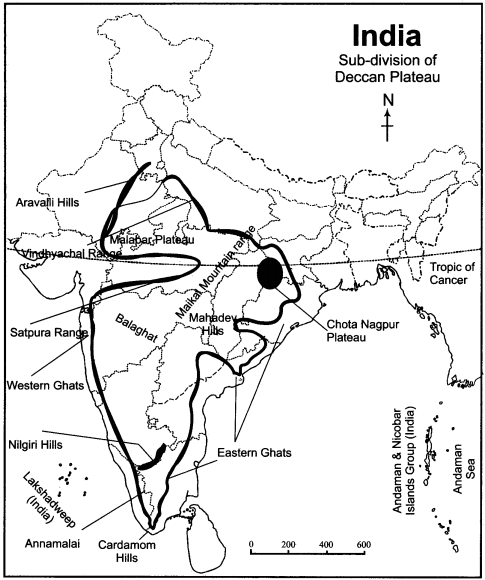
Classification of Southern Plateau:
This Plateau region of India has been divided in m three parts:
- Western Ghats
- Eastern Ghats
- Southern Plateau
1. The Western Ghats:
The western edge of the Deccan Plateau is known as the Western Ghats which has a sharp slope towards Arabian Sea. It meets the valley of Tapti and the Cape Comorin. It is 1600 km long and its northern part is covered with lava. In the southern part, the rocks like gneiss, schist and Charnockite are seen at large.
The confluence of ranges of Annamalai, Cardamom and Palani takes place at this ghat. The highest peak of this ghat is Dodabeta peak (2637 m) which is located near the hills of Nilgiri. The rivers like Godavari, Bhima, Krishna, Tungabhadra, Kaveri, Tamraparni, Periyar, etc. originate from this plateau region.
2. Eastern Ghats:
It is spread in the form of western edge of Deccen Plateau. It expands from the valley of Mahanadi in the north up till the hills of Nilgiri. The height of this ghat is less. The rocks like schist, gneiss, Charnockite and Khondalite are found in this region.
3. Southern Plateau:
It is an old body made of sand stone, limestone, igneous rocks, and the rocks of Dharwar and Gondwana system. It is formed of fertile black soil and is spread in an area of 5 lakh sq km. The plateau of Mysore, Plateau of Rayalaseema, Telangana plateau etc. are included in it. This plateau region is found mainly in the south east Rajasthan, Gujarat, Madhya Pradesh, Maharashtra, Andhra Pradesh and Karnataka.
Economic Importance of Southern Plateau:
It is a fixed landmass. It is safe from the sudden geographic disturbances. The climate in this region is even and it is rich in minerals. Its north-eastern part consisting of black soil is very important for India. All facilities related to generation of cheap electricity are available here. Due to availability of raw materials, significant industrial development is seen in this region.
Map Based Questions
Question 1.
Show the main physio – graphic regions of India on the outline map.
Answer:
The main physio – graphic regions of India are shown in the map given below:
Question 2.
Show the sub – divisions of Deccan Plateau on the map of India.
Answer:
The sub – divisions of Deccan Plateau are shown in the map given below:
RBSE Class 11 Indian Geography Chapter 4 Other Important Questions
RBSE Class 11 Indian Geography Chapter 4 Multiple Choice Questions
Question 1.
Into how many ages has the Indian geological history been divided?
(a) Three
(b) Four
(c) Five
(d) Six
Answer:
(b) Four
Question 2.
In which era are the rocks of Gondwana system found?
(a) In Dravid era
(b) In Aryan era
(c) In Purana era
(d) In Primitive era
Answer:
(a) In Dravid era
Question 3.
What per cent of Indian landmass has a height of 2 to 5 meters?
(a) 33.4 per cent
(b) 28.3 per cent
(c) 18.6 per cent
(d) 18.7 per cent
Answer:
(b) 28.3 per cent
Question 4.
By what name is the southern part of Pangea known?
(a) Laurasia
(b) Angaraland
(c) Gondwanaland
(d) Eurasia
Answer:
(c) Gondwanaland
Question 5.
The exponant of the principle of geosyncline related to mountain formation is:
(a) Kober
(b) Homes
(c) Jeffreeze
(d) Devis
Answer:
(a) Kober
Question 6.
The latest alluvial region is called:
(a) Bhabar region
(b) Terai region
(c) Bhangar region
(d) Khadar region
Answer:
(d) Khadar region
Question 7.
Akal Fossil Park is situated in:
(a) Barmer
(b) Pali
(c) Jaisalmer
(d) Jodhpur
Answer:
(c) Jaisalmer
Question 8.
Which of the following is an island formed by coral reefs?
(a) Pamban Island
(b) Pigeon Island
(c) Lakshadweep
(d) Crocodile Island
Answer:
(c) Lakshadweep
Matching Type Questions
Question A.
Match Column A with Column B:
| Column A | Column B |
| (i) Nilgiri Gneiss | (a) The rocks of Dharwar system |
| (ii) The region of Chota Nagpur plateau | (b) The rocks of Vindhyan system |
| (iii) Valley of Godavari | (c) The rocks of Archean system |
| (iv) Sandstone | (d) The rocks of Cudappah system |
Answers:
- (c)
- (a)
- (d)
- (b)
Question B.
Match Column A with Column B:
| Column A (Peaks) | Column B (Name of the division) |
| (i) Nanda Devi | (a) Eastern Ghats |
| (ii) Pir Panjal | (b) Sub – Himalayas |
| (iii) Muriya | (c) Greater Himalayas |
| (iv) Mahendragiri | (d) Smaller Himalayas |
Answers:
- (c)
- (d)
- (b)
- (a)
RBSE Class 11 Indian Geography Chapter 4 Very Short Answer Type Questions
Question 1.
Into how many eras has the Indian geological history been divided?
Answer:
The Indian geological history has been divided into four eras:
- Archean era
- Purana era
- Dravidian era
- Aryan era
Question 2.
Into how many sub – parts has Archean era been divided?
Answer:
The Archean era has been classified into two sub – eras:
- The rocks of Dharwar system.
- The rocks of Archean system.
Question 3.
Which are the regions of the rocks of Archean system?
Answer:
There are three regions in which the rocks of Archean system are found.These are Bengal Gneiss, Bundelkhand Gneiss and Nilgiri Gneiss.
Question 4.
Into which sub – divisions has the Purana Era been divided ?
Answer:
The Purana Era has been divided into two sub – divisions:
- The rocks of Cudappah system.
- The rocks of Vindhyan system.
Question 5.
Where are the rocks of Vindhya system found in India?
Answer:
The rocks of Vindhya system are found from Sasaram and Rohtas areas of Bihar state, to Chittorgarh of Aravali up to Vindhyachal mountain.
Question 6.
What is the importance of Aryan Era?
Answer:
The rocks of Aryan era started to form in the Carboniferous age. Organic materials like coal, mineral oil and natural gas are found in these rocks. So, this era has great importance even today.
Question 7.
Into which parts the Northern mountainous region has been divided?
Answer:
The Northern mountainous region has been divided into three parts:
- Greater Himalayas
- Middle Himalayas
- Sub Himalayas
Question 8.
Name the different parts of Pangea.
Answer:
The northern part of Pangea is known as Angaraland (Laurasia) and the southern part is known as Gondwana land.
Question 9.
Which are the major peaks of Greater Himalayas?
Answer:
Kanchenjunga, (8598 m), Nanga Parbat (8126 m), Makalu (8481 m), Manaslu (8156 m), Annapurna (8078 m) and Nanda Devi (7818 m) are the important peaks of Greater Himalayas.
Question 10.
Name the tourism spots present in Smaller Himalayas.
Answer:
The main tourism spots found in smaller Himalayas include Shimla, Mussoorie, Nainital, Darjeeling , Ranikhet, etc.
Question 11.
What do you understand by the terms Bugyal and Payar?
Answer:
The forests and grasslands found in the slopes in the smaller Himalayan region are called Bugyal and Payar respectively in Uttaranchal (Uttarakhand).
Question 12.
What are Dwar and Duns?
Answer:
The heigher valley plains formed with the sand in the Sivalik range are called Dwar in the east and Duns in the West.
Question 13.
Into how many parts have Himalayas been divided on regional basis?
Answer:
On regional basis, Himalayas have been divided into four regions:
- Himachal Himalaya
- Kumaon Himalaya
- Nepal Himalaya
- Assam Himalaya
Question 14.
What do you understand by the term Bangar?
Answer:
The plains which are relatively higher than the beside of land and where the flooding has no effect is known as Bangar. This type of plain is formed with older deposits.
Question 15.
Into how many parts have the Great Plains been divided on regional basis?
Answer:
On regional basis, the Great Plains have been divided into the plains of Punjab – Haryana, Ganges – Plains, Brahmaputra – Plains and the Delta of Ganges-Brahmaputra.
Question 16.
What is the meaning of Doab?
Answer:
The land which lies between two or more rivers is called Doab.
Question 17.
What is Bhur?
Answer:
The small dunes cliffs found in the dry area of Bangar region are called Bhur.
Question 18.
Name the saline water lakes found in the Thar Desert.
Answer:
The saline water lakes found in the Thar Desert are Lunkaransar, Didwana, Pachpadra, Degana, Kuchaman, Phalodi, Kawod, Parbatsar, and Sambhar.
Question 19.
Which, are the passes found in the Southern Ghats?
Answer:
Bhorghat, Thalghat and Palghat are major passes found in the Southern Ghats.
Question 20.
Name the rivers that originate from the Southern Ghats.
Answer:
The rivers that originated from the Southern Ghats are Godavari, Bhima, Krishna, Tungabhadra, Pennar, Kaveri, Tamraparni, Periyar, Vaigai etc.
Question 21.
Which type of rocks are found in the Eastern Ghats?
Answer:
The rocks such as schist, gneiss, Charnockite, and Khondalite are mainly found in the Eastern Ghats.
Question 22.
Name the smaller plateau regions into which the rivers have divided the Deccan Plateau.
Answer:
The rivers have divided the Deccan Plateau into the Plateau of Chhattisgarh, Plateau of Mysore, Plateau of Rayalseema, Plateau of Telangana and Plateau of Shillong.
Question 23.
What is meant by Lagoon?
Answer:
A lagoon is a shallow body of water separated from a larger body of water by barrier islands or reefs. Lagoons are commonly divided into coastal lagoons and atoll lagoons.
Question 24.
Into how many parts are the Indian islands divided?
Answer:
The Indian islands are mainly divided into two parts:
- Coastal islands (alluvial islands and rocky islands).
- Distant islands (mountainous islands and coral islands).
RBSE Class 11 Indian Geography Chapter 4 Short Answer Type Questions (SA-I)
Question 1.
What is the impact of the geological structure?
Answer:
The geological structure of a land mass controls the relief and the topographic situation of an area. Mountains, Plateaus and Plains found in a country depend on the geological structure. Moreover, the geological structure of a region effects the composition of soil, minerals resources, underground water, natural vegetation etc. pattern on a large scale.
Question 2.
How did the rocks of Dharwar system form?
Answer:
The rocks of Dharwar system are found over the rocks of Archean era. In some regions, two types of rocks – Archean as well as Dharwar are found nearby each other. The metamorphism and eroison of the rocks of Archean age has been taking place. During the process of this erosion, the deposits which took place, changed into the rocks of Dharwar system. Some of the rocks are badly deformed and transmuted, while others are formed by recently deposited alluvium that has yet to undergo diagenesis. Minerals deposits of great variety are found in the subcontinent in huge quantity.
Question 3.
How did the rocks of Cudappah system form?
Answer:
The formation of rocks of Cudappah system has taken place as the result of erosion of the rocks of Archean and Dharwar system. The process of formation of this type of rocks took a long time. These types of rocks are also called the sedimentary rocks. The sedimentary rocks were formed by weathering and erosion of the source area and were then transported to the place of deposition by water, wind, ice, mass movement or glaciers, which are called the agents of denudation.
Question 4.
Why is the Himalaya called a folded mountain?
Answer:
In between Laurasia and Gondwanaland, there was a long narrow and shallow ocean known as the Tethys ocean. There were many rivers which were flowing into Tethys ocean. Sediments brought by these rivers were deposited on the floor of the Tethys ocean. These sediments were subjected to powerful compression due to the northward movement of the Indian Plate. This resulted into the folding of sediments. Once, the Indian Plate started plunging below the Eurasian Plate, these sediments were further folded and raised. So, the Himalaya came into existence as a folded mountain by this process which continues even today.
Question 5.
Briefly explain the formation of mountains according to Kober.
Answer:
According to Kober, geosyncline is the base of the formation of mountains. He considered that there were deposits of sediments in Tethys ocean brought by many rivers. When these sediments were subjected to powerful compression due to the northward movement of the Indian plate, this resulted into the folding of sediments. Once, the Indian Plate started plunging below the Eurasian plate, these sediments were folded further and raised and turned into folded mountains.
Question 6.
Write the characteristics of the Shivalik range.
Answer:
The characteristics of Shivalik range have been given as below:
- It is the northern – most range of Himalayas, also called the Outer Himalayas.
- It is the outermost range of Himalayas.
- It is made of consolidated materials such, as mud, silt and soft rocks.
- Some narrow Valleys are found between Shivalik and Himachal. They are called Duns.
- It is prone to earthquakes and landslides.
- The range of Shivalik is covered with thick forests.
- It is the latest formation of the Himalayas.
Question 7.
Describe the steps taken to stop the extension of the Thar Desert.
Answer:
To stop the extention of the Thar Desert, following steps have been taken:
- Strips of plants and trees have been developed as mono block stopper, so that the sand may not spread to far off places.
- Semi – arid vegetation has been developed in the arid regions.
- To stop the extention of desert, Central Arid Zone Research Institute was established in Jodhpur.
- After the development of the Indira Gandhi canal, its irrigated area has been increased so that the soil erosion may be reduced with the help of wet condition.
- Rain water is being harvested so that the level of groundwater may be raised.
Question 8.
Describe the importance of islands.
Answer:
The importance of islands in India is given as below:
- Due to being surrounded by oceans, the climate of islands is always even.
- Due to their natural beauty and charm, islands always have been the point of attraction for the tourists.
- They are separated from the main land, so bio – diversity is seen there.
- The islands extend an important contribution in providing assistance to the trading ships in times of emergency.
- Indian islands are situated in the Indian Ocean, so they are important with strategic viewpoint.
- The Indian islands are very important with naval point of view.
RBSE Class 11 Indian Geography Chapter 4 Short Answer Type Questions (SA-II)
Question 1.
Describe the physio – graphic characteristics of Northern Mountainous region.
Answer:
The physio – graphic characteristics of northern mountainous region spread to the north of India are:
- It is a newly folded mountain whose width keeps on increasing from the east towards the west.
- It’s height goes on decreasing to from the east towards the west.
- This is a combination of several mountainous ranges.
- This mountain range has a rapid slope towards India while it is found to be slow towards Tibet.
- The mountain peaks are for away from each other.
- The eastern part of Himalayas is sharply elevated from Uttar Pradesh and Bengal due to which the peaks of Everest and Kanchenjunga are visible from the plains.
- The peaks of Nanga parbat, Badrinath, Nanda Devi cannot be seen from the plains.
Question 2.
Compare the Bhabar and Terai region.
Answer:
The comparative description of Bhabar and Terai region has been given as follows:
| Bhabar | Terai |
| 1. It lies along the foot hills of the Shivaliks from the Indus to the Tista river. | 1. It lies to the south of the Bhabar and runs parallel to it. |
| 2. It is 8 to 16 km wide. | 2. It is 20 to 30 km wide. |
| 3. It comprises of pebble studded rocks in the shape of porus beds. | 3. It is composed of comparatively finer alluvium and is covered by forests. |
| 4. Due to porosity of the rocks, the stream disappear and flow underground. | 4. The underground’ streams of the Bhabar re – emerge on the surface and give birth to marshy area. |
Question 3.
Describe the diversities between Bangar region and Khadar region.
Answer:
A diversities between Bangar region and Khadar region can be given as below:
| Bangar Region | Khadar Region |
| 1. It is the largest part of Northern Plain. | 1. It is not as large as the Bhangar region. |
| 2. It is made up of old alluvium and does not have good granules. | 2. It is made of newer alluvium and fine granules. |
| 3. The soil in this region is not renewed frequently and it is old alluvial soil. | 3. The soil is frequently renewed due to frequent flooding. |
| 4. It contains calcareous deposits locally known as ‘Khankar’. | 4. It does not contain calcareous deposits of calcium. |
| 5. It is not very fertile. | 5. It is very fertile and suitable for extensive cultivation. |
Question 4.
Thar desert is a result of a long process. Explain.
Answer:
The Thar Desert has extended in the western part of India. It is formed by ancient deposits and is a physio – graphically arid region. There are different views about the origin of Thar. Some scholars consider that the sand found in the Thar is a result of erosion and decomposition of different rocks. On the other hand, some scholars believe that there was wet climate in this part long time ago, but due to some reason, aridness kept on increasing and it turned into a desert.
Some scholars believe that long years ago, it was a fertile land and many rivers flowed through this part, but due to some disturbances, this area rose up and the flow of the rivers here was captured by the Rivers Ganga and Yamuna and so the aridity of this area increased at large, and as a result, the Desert of Thar came into existance. But a scholar Law – Toosh says that the Thar Desert was formed by the sand which was brought and deposited by the south – western strong storms.
Question 5.
Describe the importance of Thar Desert.
Or
“The Desert of Thar is a boon for India.” How ? Discuss.
Or
“The Thar Desert is developing as an important industrial region in India.” How?
Answer:
The importance of Thar Desert can be explained with the help of the following points:
- The Desert of Thar becomes very’warm in summer and turns into the center of low air pressure. So the summer monsoons (south-west) get attracted towards it and cause rainfall in India.
- The minerals like mica, gypsum, copper, marble, asbestos, rock phosphate, feldspar, mineral oil and natural gas make it important economically.
- It has strategic importance as it acts as a barrier between India and Pakistan.
- Due to physical diversities, it attracts many tourists towards India.
- The semi – arid regions of Thar are suitable for animal herding.
- The soil found here is fertile and the availability of water for irrigation purposes can transform it into agricultural land.
Question 6.
Describe the importance of coastal plains found in India.
Answer:
The importance of coastal plains found in India can be described as given below:
- The coastal plains found in India are fertile and so they are helpful in the cultivation of major food crops like rice and cash crops like coconut are also grown in these areas.
- The coastal plains provide very favorable conditions for the plantation of coconut, cashew nuts, beetle nuts, rubber and palm.
- The fishery farms are also present here.
- The major ports of India are built here, which are very important for international trade and business.
- The salt production is also done in the coastal plains.
- The sands in the coastal plains have large amount of monozite mineral, that is used to generate nuclear power.
- Many tourist spots have developed here such as Panaji, Madgaon, Juhu, Chennai, Puri, Vasco – da – Gama etc.
Question 7.
Describe the coastal islands of India.
Answer:
The coastal islands found in India have been divided into two parts:
- Alluvial islands
- Rocky islands
1. Alluvial Islands:
Alluvial islands are found on the eastern coast of India. Apart from Chilka Lake near Bhasara and Mandala, all the islands are made of alluvial soil. The important alluvial islands are Sagar island situated at the mouth of River Hooghly, Shaurt island in the Delta of Mahanadi and river Brahmani, and at its mouth, Wheelar island. Ramsetu between India and Sri Lanka, Pamban island of Rameswaram, Crocodile island situated in the valley of of Mannar and Kota island.
2. Rocky Islands:
Such islands are found on the western coasts out which Henry, Canary, Buchar, Elephanta, Pigeon near. Mumbai and Piram, Bhainsala etc. at the coast of Kathiawar are important islands.
Question 8.
Describe the distant Islands of India.
Answer:
The islands that are located far away from the sea coast are called distant islands. These types of islands found in India are mainly divided into two parts:
- Mountaineous Islands
- Coral Islands
1. Mountaineous Islands:
In this category, those islands are included which have risen up over the plunged mountain ranges. The most important example of this type of islands are the islands of Andaman-Nicobar. Andaman and Nicobar islands were formed due to collision between Indian Plate and Burma Minor Plate. Andaman and Nicobar islands are Southward extension of Arakan Yoma mountain range.
2. Coral Islands:
A coral island is a type of island formed from coral reefs and associated organic materials. They are formed in tropical and sub tropical areas, typically as part of coral reefs which have grown to offer a far larger area under the sea. These types of islands are found in the Arabian Sea in India. Chains of Lakshadweep islands are an excellent example of coral islands.
RBSE Class 11 Indian Geography Chapter 4 Essay Type Questions
Question 1.
Explain the geological history of India.
Answer:
The geological history of India is full of diversities. The Indian rocks had been formed in different ages and time periods. According to the composition of rocks system, Indian geological history can be classified as given below:
1. Archean Era:
It is the oldest period of the geological history of India. The rocks of Archean era have been divided into two categories:
- Rocks of Archean system
- The rocks of Dharwar system
Rocks of Archean System:
The rocks of Archean system are the oldest and granular, in which the absence of fossils is found. The rocks found in Bengal, Bundelkhand and Nilgiri Gneiss are included in the Archean system.
Rocks of Dharwar System:
The rocks of Dharwar system are found over the rocks of Archean system. These rocks are made due to the erosion of different substances. The spread of these types of rocks is found in Mysore Dharwar – Bellary, Chota Nagpur, Aravallis, Punjab and Trans-Himalayan region.
2. Purana Era:
The Purana Era comes after the Archean Era. These types of rocks are also divided into two parts:
Rocks of Cudappah system:
The Cudappah system is composed of a number of parallel series of ancient sedimentary starta of great thickness. Slate, Quartzite, and linestone are the main rocks of Cudappah system. Such rocks are found mainly in Krishna, Pennar, Papakani rivers, Nallamalai, Venkonda, Valley of Godavari and Delhi.
Rocks of Vindhyan System:
Mainly composed of indisturbed sand stones, shales and limestone, reaching a thickness of up to 4000 meters, the Vindhyan system occupies about one lakh km area, stretching from Sasaram and Rohtas in western Bihar to Chittorgarh in Rajasthan. It covers a large area of Madhya Pradesh, Chhattisgarh, Uttar Pradesh and Rajasthan.
3. Dravidian Era:
Under this era, rocks of Gondwana system are included. Their extension is found in the valley of Damodar, Valley of Mahanadi and Godavari, Satpura hilly range, hills of Rajamahal, Kutch, Kathiawar, Kashmir and Spiti region. Rocks of this system are mainly found in southern India.
4. Aryan Era:
The formation of this era started in the Carboniferous age. So these rocks have a great important with the point of view of minerals i.e., coal, mineral oil, natural gas. The rocks of this system are latest rocks.
Question 2.
Describe the regional classification of the Himalayas.
Or
Give a regional description of Himalayas.
Answer:
Himalayas is a major physiological division spread to the North of India. The extension of this physical region is seen in several zones. The natural form of Himalayas is classified into three divisions:
- Himachal Himalaya
- Kumaon Himalaya
- Nepal Himalaya
- Assam Himalaya
1. Himachal Himalaya:
Its extension is found from River Indus to River Sutlej. This part covers an area of 570 km in length which is spread mainly in Jammu and Kashmir , and Himachal Pradesh. The ranges like Pir Panjal, Dhauladhar, Zaskar, Ladakh etc. are found in this region. The valleys of Kangra, Lahul and Spiti are also found here, in which the plantation farming of fruits is done.
2. Kumaon Himalaya:
The length of this part of Himalaya is 320 km which extends from the River Sutlej to River Kali. This region is higher than of Himachal Himalaya, in which the peaks like Badrinath (7138 meters), Kedarnath (6831 meters), Trishul (6770 meters) and Gangotri (6580 meters), are found. The origin of Rivers Ganga and Yamuna is there in this region. There are many tourist spots here, in which Kedarnath, Badrinath, Gangotri, Yamunotri are the major ones.
3. Nepal Himalaya:
The length of this part of Himalaya is 800 km which extends from Kali River to Teesta. Most of its part is found in Nepal, so it is called the Nepal Himalaya. It is also known as the Sikkim and Bhutan Himalaya and Darjeeling Himalaya. It is the highest part of Greater Himalayas in which the peaks like Mount Everest, Kanchejunga, Makalu, Dhaulagiri and Annapurna are found, which are always covered with snow.
4. Assam Himalaya:
This part of Himalaya extends from the River Teesta to Brahmaputra. The length of this region is 740 km. The main peaks of this part of Himalaya are Kangto (7060 m), Nyegyi Kangsang (7047m), Namcha Barwa (7782 m) and Gyala Peri (7294 m). It has thick forests in which many tribes dwell. The Naga Hills act as a water divider between India and Myanmar.
Question 3.
There are diversities on the regional basis in the Great Plains of India. How? explain.
Answer:
The Great Plains of India extend from River Sutlej to the valley of River Brahmaputra. This plain has been divided on regional basis into the following zones:
- Punjab – Haryana Plains
- Ganges Plains
- Brahmaputra Plains
- The Delta of Ganga and Brahmaputra
1. Punjab – Haryana Plains:
This plain is spread in Punjab and Haryana. The north western Part of this plain has been formed by the deposits of alluvial soils brought out by the rivers Sutlej Beas, Ravi, Chenab and Jhelum. Doabs are found in this plain. The Bari Doab is located between the Rivers Beas and Ravi. The flood effected areas of two sides of rivers are called ‘Bat’ and pits formed in this way are called ‘Cho’. The plains of River Ghagghar found in this area are called the Haryana plains.
2. Ganges Plains:
This plain is very fertile and even and is formed by the deposited sediments brought by the River Ganga and its tributaries Yamuna, Gomati, Ghagara, Gandak, Kosi, Betwa, Ken, Chambal and Son. This plain is spread from North of Aravalli up to West Bengal. It extends in eastern Rajasthan, Uttarakhand, Uttar – Pradesh, Jharkhand, Bihar and West Bengal. The slope of this plain is towards the east and the south – east. The small dunes found in this plain are called “Bhur”. In this plain, the regions of Rohilkhand, Awadh, Jharkhand and Bihar are included.
3. Brahmaputra Plains:
It is mainly known as the Plain of Assam. It is spread between the Himalayas and Garo hills. It is narrow and long which has been formed with the alluvial soil brought out by Brahmaputra River. The length of this plain is 65 km from Dhubri to Sadiya and its width is 100 km. Due to the obstruction caused by the exuberance of soil in Brahmaputra River, many islands have been formed.
4. The Delta of Ganga – Brahmaputra:
It is an even and a plain of less height, in which tidal water spreads all over. That is why this region is always marshy. The land that does not come under the influence of tidal water is called ‘Char’, and the land that comes under the influence of tidal water is called “Bil”.
Question 4.
Describe the value of Great Plains in India.
Or
The great Plains are like the back-bone of India. Explain.
Or
Explain the utility and importance of the Central Plain region of India.
Answer:
The North Plains or the central plains region has great importance for India, which can be described as given below:
- Due to being formed by alluvial soil, it is a very fertile plain.
- A network of rivers is spread in this land, which are very useful for irrigation, water transport, generating hydro – electricity and for industries.
- The deposit of new – soil every year makes it ideal for agriculture.
- Since the farming of sugarcane, tea, rice, wheat and cotton is done at a large scale in this zone, so it is called the storehouse of food grains.
- 45 per cent population of India resides here, therefore it is called the human belt of India.
- Due to presence of even surface in this plain, a developed network of road transportation is seen here.
- Metro – polition cities and industrial and trading centers have developed here.
- All the facilities regarding lifeline and standard of living are available here.
- Besides trading facilities, there are many tourist places found in this plain.
- Due to availability of every type of facility, industrial progress and development is seen everywhere.
Question 5.
Describe the coastal plains of India.
Answer:
In India, there are coastal plains on both the sides of Deccan Plateau. The formation of both the coastal plains has been done either by the rising up of the coastal pasts above the sea level or by the deposit of sand brought by the rivers. The coastal plains of India are divided into two parts:
1. Western Coastal Plains:
This is a strip of coastal plain 50 km in width spread from the Gulf of Khambat up to Cape Comorin between the west coast of India and the Western ghats hills, which starts near the south of Tapti River. The rivers along the coast form estuaries and provide ideal conditions for Pisciculture.
The Plains begin from Gujarat in the north and from Kerala in the south. It also includes the states of Maharashtra, Goa and Karnataka. It consists of three sections. The Northern Part of the coast is called Konkan coast. The central stretch is called Kannada Plain, while the southern stretch is reffered to as the Malabar Coast. On its northern side, there are two gulfs – Gulf of Khambat and Gulf of Kutch.
2. Eastern Coastal Plains:
It refers to the wide stretch of landmass of India, lying between the Eastern Ghats and Bay of Bengal. These plains are wider and leveled as compared to the western coastal plains. It stretches from Tamil Nadu in the south up to Bengal in the north. Lake Chilka is an important feature along the eastern coast. Deltas of many of Indian rivers form a major portion of these plains. The Mahanadi, Godavari, and Krishna rivers drain these plains.
The region receives both the North – eastern and south – west monsoon rains with annual rainfall averaging from 100 cm to 300 cm. The width of the plains varies between 100 to 130 km. It is locally known as Northern Circar Coast in the northern part Between Mahanadi and Krishna rivers and between Krishna and Kaveri Rivers there is Coromandel Coast.