Rajasthan Board RBSE Class 11 Indian Geography Chapter 5 Drainage System of India
RBSE Class 11 Indian Geography Chapter 5 Text Book Questions
RBSE Class 11 Indian Geography Chapter 5 Multiple Choice Questions
Question 1.
The effect of inclination of peninsular plateau falls on the aspect is that:
(a) Structure
(b) Plateau age
(c) Direction of water flow
(d) Topographies
Answer:
(c) Direction of water flow
Question 2.
Choose the group of rivers from the following that drain into the Bay of Bengal.
(a) Mahanadi, Krishna, Kaveri and Narmada
(b) Ganga, Brahmaputra, Krishna, and Tapti
(c) Ganga, Brahmaputra, Krishna and Kaveri
(d) Ganga, Godavari, Krishna and Sabarmati
Answer:
(c) Ganga, Brahmaputra, Krishna and Kaveri
Question 3.
Choose the group of rivers from the following whose all rivers make up delta
(a) Kaveri, Krishna, Narmada and Tapti
(b) Godavari, Krishna, Kaveri and Ganga
(c) Mahanadi, Krishna, Kaveri and Narmada
(d) Ganga, Godavari, Krishna and Narmada
Answer:
(b) Godavari, Krishna, Kaveri and Ganga
RBSE Class 11 Indian Geography Chapter 5 Very Short Answer Type Questions
Question 1.
Tapti river is a part of which drainage system?
Answer:
Tapti is a part of Arabinm drainage system in Peninsular India.
Question 2.
What is Water Divider ?
Answer:
High area that divides water flow of a region in the specific conditions is called water divider.
Question 3.
Ghaggar river iso a part of which drainage system?
Answer:
River Ghaggar is a part of inland drainage system.
RBSE Class 11 Indian Geography Chapter 5 Short Answer Type Questions
Question 1.
Name the main tributaries that are found on the left bank of the River Ganga.
Answer:
The tributaries found on the left bank of the River Ganga are Ramganga, Gomati, Ghaghara, Gandak, Kosi and Mahananda.
Question 2.
Why are the rivers originating from Himalayas more important for India?
Answer:
Importance of rivers originating from Himalayas.
- These rivers have enough water for the flow round the year.
- Even during the summer, they provide water.
- Many pilgrimage places have developed on the banks of these rivers i.e., Kedarnath, Badrinath, Haridwar, Gangotri, Yamunotri, Rishikesh etc.
- Many types of herbs and medicines are found in the drainage area of these rives.
- These rivers provide facilities of water transport.
- These rivers have formed the drainage plains.
Question 3.
Explain the inland drainage system with example.
Answer:
A type of river which drains into the land or lakes and does not reach the sea is called the inland drainage system. Luni river in Rajasthan and Sabarmati river in Gujarat are the examples of inland drainage system. Such rivers are seasonal and flow only on surface of two earth. The rivers Kankani, Kantali, Sabi, and Mantha etc. are seasonal rivers and drain into the desert.
RBSE Class 11 Indian Geography Chapter 5 Essay Type Questions
Question 1.
Explain Indian drainage system.
Answer:
The rivers found in India present variations at the regional base. The drainage system is classified into three categories at geographic base:
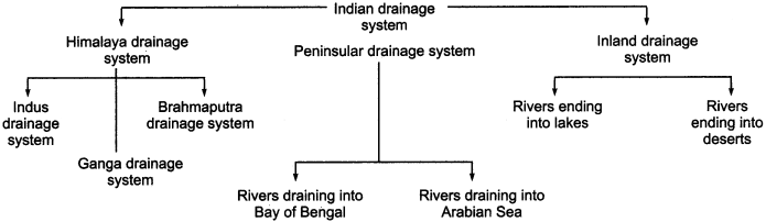
1. Himalayas Drainage System:
It is also known as Northern India drainage system. Most of the rivers of this system are originate from Himalayas. That’s why they are rivers are with regular flow and provide water even in the summer. This system again has been classified into three parts.
(a) Indus Drainage System:
It is the group of river Indus and its tributaries. It covers an area of 11.50 lakh sq. km, out of which only 3.25 lakh sq. km area is in India and the remaining area is in Pakistan since partition.
(b) Ganga Drainage System:
It is the group of Ganga and its tributaries. This drainage system streches to 8.6 lakh sq. km. The Rivers Chambal Betwa, Ken, Ramganga, Gomati, Ghaghara, Gandak, Kosi, Mahananda, Sone etc. are included in this system.
(c) Brahmaputra Drainage System:
It is a group of river Brahmaputra and its tributaries in which Dibang, Bhareli, Manas, Subansiri, Lohit, Kapali, Buri, Dihing, etc. are included.
2. Peninsular Drainage System:
It is found in Southern peninsular plateau which has been mainly divided into two parts, that is the rivers that drain into Bay of Bengal and the rivers that fall into Arabian sea.
(a) The Rivers that Drain into Bay of Bengal:
The rivers like Damodar, Subarnarekha, Brahmani, Mahanadi, Godavari, Bhima, Krishna, Tungabhadra, Palar, Kaveri, Vaigai etc. are included is this system.
(b) The Rivers that Drain into Arabian Sea:
Under this system Tapti and Narmada are the main and the longest rivers. Sabarmati, Mahi, Sukari, Bandi, Sharavati etc. rivers are also included in this group.
3. Inland Drainage System:
Under this system the rivers that end in the lakes are Sabi, Mantha and Luni, and the rivers that end in deserts are Ghagghar and Kantali.
Question 2.
Compare the Himalayan drainage and Peninsular drainage system.
Answer:
Comparison of Himalayan drainage and Peninsular drainage system.
| Himalayan Drainage System | Peninsular Drainage System |
| 1. The origin of most of the rivers of this system is Himalayan region. | 1. The origin of most of the rivers of this system is hilly areas of southern plateau. |
| 2. Rivers flow is regular and provide water even in summer. | 2. Some of the rivers of this system dried up during summer. |
| 3. These rivers flow due to melting ice of the Himalayas. | 3. These rivers get rain water to maintain their flow. |
| 4. Most of the rivers of this system flow north to south.. | 4. Most of the rivers of this system flow west to east or south to east. |
| 5. The rivers of this drainage system has been divided into Indus, Ganga and Brahmaputra drainage system. | 5. The rivers of this drainage system has been divided into two parts-draining in Bay of Bengal and in Arabian sea. |
| 6. There river made great plain of India. | 6. By these river delta and estvaryesare made mainly. |
| 7. In this drainage system many confluence and religious center are developed. | 7. In this drainage system many water fall and ghats are found. |
| 8. In this drainage system water transportation facility is available. | 8. In this drainage system fisheries facility is available. |
Map Based Questions
Question 1.
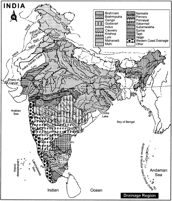
Show the routes of important rivers of India in the map.
Answer:
The Routes of chief rivers of India are as follows:
RBSE Class 11 Indian Geography Chapter 5 Other Important Questions
RBSE Class 11 Indian Geography Chapter 5 Multiple Choice Questions
Question 1.
Which of the mountain range in Rajasthan works as water divider?
(a) Aravalli
(b) Vindhyachal
(c) Satpura
(d) Kamet
Answer:
(a) Aravalli
Question 2.
The origin of the river Ganga is:
(a) Hemkund
(b) Gangotri Glacier
(c) Siachin Glacier
(d) Mansarover Lake
Answer:
(b) Gangotri Glacier
Question 3.
Which is called the Sorrow of Bihar?
(a) Saryu river
(b) Sone river
(c) Kosi river
(d) Hooghly river
Answer:
(c) Kosi river
Question 4.
Which river is known by the name of Tsangpo?
(a) Ganga
(b) Yamuna
(c) Ghaghara
(d) Brahmaputra
Answer:
(d) Brahmaputra
Question 5.
The river that found on the right bank of Brahmaputra is:
(a) Dibang
(b) Bhareli
(c) Kapali
(d) Lohit
Answer:
(b) Bhareli
Question 6.
The river which is called the Sorrow of Bengal is:
(a) Hooghly
(b) Pennar
(c) Bhima
(d) Damodar
Answer:
(d) Damodar
Question 7.
The river that does not fall into Arabian sea is:
(a) Luni
(b) Mahi
(c) Kaveri
(d) Sabarmati
Answer:
(c) Kaveri
Question 8.
The origin point of Narmada river is:
(a) Maikal
(b) Aravalli range
(c) Amarkantak
(d) Mahabaleshwar
Answer:
(a) Maikal
Question 9.
The state in which Sambhar Lake is situated is:
(a) Punjab
(b) Haryana
(c) Rajasthan
(d) Gujarat
Answer:
(c) Rajasthan
Question 10.
Which of the following is a part of Inland drainage system?
(a) Bhima
(b) Krishna
(c) Luni
(d) Kankani
Answer:
(d) Kankani
Question 11.
Bhakra Dam is built on:
(a) Indus river
(b) Sutlej river
(c) Kosi river
(d) Brahmaputra river
Answer:
(b) Sutlej river
Question 12.
Kapildhara is a:
(a) River
(b) Gorge
(c) Waterfall
(d) Canyon
Answer:
(c) Waterfall
Matching Type Questions
Question A.
Match the Column A with Column B:
| Column A (River) | Column B (Originating Place) |
| (i) Ganga | (a) Yamunotri |
| (ii) Yamuna | (b) Kailash Mountain |
| (iii) Narmada | (c) Rakshasa Tal |
| (iv) Satluj | (d) Peak of Amarkantak |
| (v) Brahmaputra | (e) Gangotri |
Answers:
- (e)
- (a)
- (d)
- (b)
Question B.
Match the Column A with Column B:
| Column A (River) | Column B (Drainage System) |
| (i) Jhelum | (a) Bay of Bengal |
| (ii) Yamuna | (b) Arabian Sea |
| (iii) Manas | (c) Indus drainage |
| (iv) Krishna | (d) Ganga drainage |
| (v) Sharavati | (e) Brahmaputra drainage |
Answers:
- (c)
- (d)
- (e)
- (a)
- (b)
RBSE Class 11 Indian Geography Chapter 5 Very Short Answer Type Questions
Question 1.
Where did Indian civilization and culture develop?
Answer:
Indian civilization and culture developed in plain areas of valleys and banks of rivers.
Question 2.
Where are most of Indian religious cities located?
Answer:
Most of Indian religious cities are located on the banks of rivers.
Question 3.
Which is the most interesting changing route of rivers in India ?
Answer:
The most interesting changing route of rivers is found in Indus – Brahmaputra rivers.
Question 4.
Into how many parts does the water divider line divide India?
Answer:
The water divider line divides India into three drainage – Arabian sea drainage, Bay of Bengal drainage and Inland drainage.
Question 5.
Which is called Arabian Sea drainage system?
Answer:
The part of water divider line from where water drains into Arabian Sea is called the Arabian Sea drainage region.
Question 6.
According to geographical perspective, into how many parts has the Indian drainage system been divided?
Answer:
According to geographical perspective, Indian drainage system has been divided into three parts:
- Himalayan drainage system
- Peninsular drainage system
- Inland drainage system
Question 7.
Where does the river Satluj originate from?
Answer:
The river Satluj originates from a region named Rakshas Tal near Mansarovar lake.
Question 8.
How does river Ganga form?
Answer:
The river Ganga forms by merging of water streams of Alaknanda and Bhagirathi in Devprayag.
Question 9.
Why is river Kosi called the Sorrow of Bihar?
Answer:
Kosi river keeps changing its route, due to which the incidences of flood bring immense loss of life and property in Bihar, thus the river Kosi is called the Sorrow of Bihar.
Question 10.
Name the rivers that drain into river Brahmaputra from the left side.
Answer:
The rivers that drain into river Brahmaputra from the left side are Dibang, Lohit, Kapili, Dhansiri, Buri, Dihing etc.
Question 11.
Name the rivers that drain into the river Brahmaputra from the right side.
Answer:
The rivers like Bhareli, Subansiri and Manas drain into Brahmaputra from the right side.
Question 12.
Which rivers fall into Bay of Bengal?
Answer:
Rivers like Damodar, Subarnarekha, Brahmani, Mahanadi, Godavari, Bhima, Krishna, Tungabhadra, Painar, Palar, Kaveri and Vaigai fall into Bay of Bengal.
Question 13.
Why is the river Damodar called the sorrow of Bengal?
Answer:
Damodar river due to floods and changes in its path brings loss of immense public and wealth in Bengal. Thus, the river Damodar is called the sorrow of Bengal.
Question 14.
Which rivers flow through rift valley.
Answer:
Narmada, Tapti, Chambal and Damodar rivers flow through rift valley.
Question 15.
Name the rivers that fall into the Arabian Sea.
Answer:
The rivers that fall into Arabian Sea are Narmada, Tapti, Luni, Sabarmati, Mahi, Sukari, and Sharavati.
Question 16.
Name the waterfalls that are formed by the river Narmada.
Answer:
The waterfalls that formed by the river Narmada are Kapildhara, Dudh-dhara. Sahastra-dhara, Dhuandhar, Ghaghri and Hiran waterfalls.
Question 17.
In which area does the Inland drainage system stretch?
Answer:
Inland drainage system stretches from Sambhar lake in Rajasthan to Ghaggar drainage area in Haryana.
RBSE Class 11 Indian Geography Chapter 5 Short Answer Type Questions (SA-I)
Question 1.
Describe the importance of rivers in India.
Answer:
There is an important contribution of rivers in the development of Indian culture and civilization. Many religious, historical, traditional and industrial cities are located on the banks of different rivers. Rivers provide water for irrigation, generating hydro-electricity, water transport and industrial purposes. Thus they play an important role in economic development of India. The Indian culture and civilization have developed on the banks of these rivers.
Question 2.
What changes have take place in Indus – Brahmaputra drainage system?
Answer:
Earlier, Indus Brahmaputra drainage originated from the north – eastern part of Assam and while running parallel to the Himalayas, it flowed towards the west upto sulaiman – kirthar ranges and then drained into the Arabian sea while flowing in the south Later on, as a result of geologic incidents, the north – western part of Shivalik river separated in the form of Indus river and the eastern part in the form of Brahmaputra river.
Question 3.
Where does water divider line of India extend from and up to?
Answer:
Any elevated area, such as a mountain or an upland, which separates two drainage basins is known as water divider. For example, the water divider between Indus and Ganga river system is important. Water divider line of India starts from Manasarovar lake passes through Kamet mountain, and after entering Udaipur with Aravalis includes the valleys of rivers Narmada and Tapti is extending to Kanyakumari along with Western Ghats.
Question 4.
Describe the Brahmaputra Drainage system.
Answer:
The Brahmaputra also, known as Tsangpo in Tibet is one of the main rivers in Asia. It has its origin in the Kailash mountain near Manasarovar Lake. It is as long as river Indus. It carries a huge amount of silt. It flows parallel to the Himalayan mountains in Tibet. It takes U – turn at Namcha Barwa and enters into Arunachal Pradesh. It flows into the Bay of Bengal and the just before falling into it, it forms streams of the distributaries due to excess deposits of sediments and silt.
RBSE Class 11 Indian Geography Chapter 5 Short Answer Type Questions (SA-II)
Question 1.
Distinguish between Indus and Ganga drainage system.
Or
Describe differences between Indus and Ganga drainage system.
Answer:
The differences between Indus and Ganga drainage system are as follows
| Indus River Drainage | Ganga River Drainage |
| 1. The river has a total drainage area of 11.50 lakh sq. km, out of which area of 3.25 lakh sq. km in India. | 1. The river has a total drainage area of 8.6 lakh sq. km. |
| 2. The rivers of this drainage system fall mainly into Arabian Sea. | 2. The rivers of this drainage system fall into Bay of Bengal. |
| 3. The rivers under this system form Gorges. | 3. The rivers under this system form the fertile plains. |
| 4. Doabs are found in this system. | 4. The Confluences are found in this system. |
Question 2.
Compare the rivers of Bay of Bengal and that of Arabian Sea.
Or
Distinguish between the rivers of Bay of Bengal and Arabian Sea.
Answer:
Differences between rivers of Bay of Bengal and rivers of Arabian Sea.
| Drainage of Arabian Sea | Drainage of Bay of Bengal |
| 1. This drainage system has developed due to the height of the western part of the western Ghats of the peninsular plateau and due to its slope towards the Arabian Sea. | 1. This drainage system has developed due to the inclination of the peninsular plateau towards the east. |
| 2. Due to steep slope the flow of rivers is rapid. | 2. Due to gentle slope the flow of rivers is slow. |
| 3. The form of tidal – river is found in this system. | 3. The form of deltas is found in this system. |
RBSE Class 11 Indian Geography Chapter 5 Essay Type Questions
Question 1.
Describe the importance of flowing rivers in India?
Or
Describe the utility of drainage system of India.
Answer:
Indian rivers have a matchless position in the world due to their specific importance. The importance of these rivers can be expressed with the points given below:
- The fertile plains in India have been formed by the rivers.
- The alluvial soil carried by the Indian rivers is like a nectar for farming.
- Rivers provide water for irrigation purposes.
- The occupation of pisciueulture is performed in Indian rivers.
- Rivers provide water transport.
- Many religious, historical, traditional and industrial cities have developed on the banks of Indian rivers.
- The rivers have given an important contribution in the establishment and development of industries.
- The waterfalls of the rivers are helpful to generate electricity.
- Many religious centers have developed on the confluence of rivers.
- Rivers have been promoting the tourism in India since beginning.
- The tree belts developed on both sides of the rivers have been promoting forests.
- The rivers provide many organic and inorganic substances.
- Due to the rivers, the confluence of different cultures and civilizations is established.
- Rivers rise up the underground water level.
- Rivers provide the building materials as well as water for industrial purposes.