Rajasthan Board RBSE Class 11 Physical Geography Chapter 10 Agents of Erosion
RBSE Class 11 Physical Geography Chapter 10 Text Book Questions
RBSE Class 11 Physical Geography Chapter 10 Multiple Choice Questions
Question 1.
Topography formed from the deposition by rivers is known as:
(a) Gorge
(b) Alluvial fan
(c) Pot hole
(d) Waterfall
Answer:
(b) Alluvial fan
Question 2.
Topography formed from the erosion of sea waves is known as:
(a) Cliff
(b) Delta
(c) Mushroom rock
(d) Doline
Answer:
(a) Cliff
Question 3.
Erosional topography is not formed by wind is:
(a) Dune
(b) Mushroom rock
(c) Inselberge
(d) Zeugen
Answer:
(a) Dune
Question 4.
Which topography is not formed from glacial erosion?
(a) Fjord
(b) Glacial steps
(c) Glacial peak
(d) Esker
Answer:
(d) Esker
Question 5.
Wavy projections found in desert regions are known as:
(a) Sand dunes
(b) Ripples
(c) Barkhan
(d) Loess
Answer:
RBSE Class 11 Physical Geography Chapter 10 Very Short Answer Type Questions
Question 1.
How are alluvial cones formed?
Answer:
When debris gets deposited in the shape of cones on mountainous slopes at the place where time a river enters from the mountains into the plains, it is known as alluvial cone.
Question 2.
What is gorge?
Answer:
Gorge refers to a narrow valley between hills or mountains, typically with steep rocky walls and a stream running through it.
Question 3.
Write the name of the lake which forms when water gets filled up in the cirque.
Answer:
In glacial regions, when water gets filled up in cirque type basins, the lake thus formed is known as Tarn/Tarn Lake.
Question 4.
Write the name of the topography which resembles an egg basket in shape.
Answer:
In glacial regions, the egg – shaped topography which is formed during the process of deposition by the deposit of boulder bodies is known as Drumlin.
Question 5.
What is Yardang?
Answer:
In desert regions, when the wind erodes the gentle and solid rocks into pointed land forms formed by sequential layers, such topography is known as Yardang.
RBSE Class 11 Physical Geography Chapter 10 Short Answer Type Questions
Question 1.
How is Ox – Bow lake formed?
Answer:
After a long period of time, the meander becomes very curved, and eventually the neck of the meander becomes narrower and the river cuts through the neck during a flood, cutting off the meander and forming an oxbow lake.
Question 2.
How is a lagoon formed?
Answer:
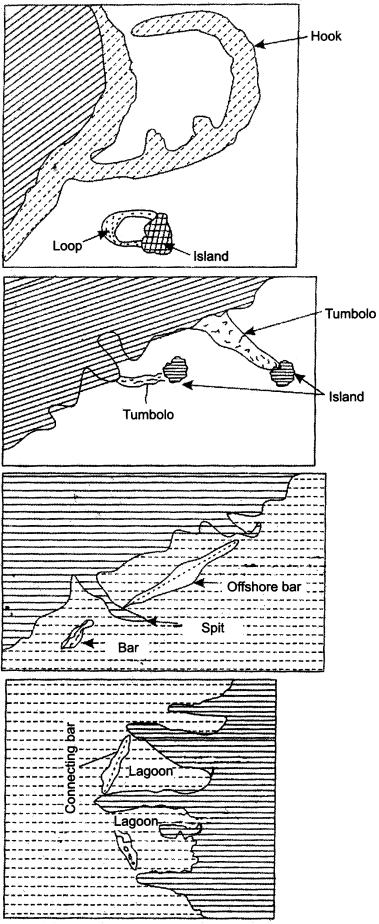
Lagoons are shallow, often elongated bodies of water separated from a larger body of water by a shallow or exposed shoal coral reef or similar feature. Lagoon is an elongated narrow saline – water lake. It provides security to coast which is associated with the sea even after its formation. Such lakes which are found at the conjunction of bars and beaches are known as lagoons.
Question 3.
How is mushroom rock formed?
Answer:
In desert regions, rocks which are projected above the normal surface, are eroded upper part at their due to continuous blowing of wind in less amount, because the major erosive material sand flows a few feet above the surface and more erosion takes place near the lower surface. The mushroom – type or snake’s – umbrella type structure which is formed due to this process is known as mushroom rock. Seasonal conditions, such as: wind, rainfall, temperature, etc. affect these types of topographies.
Question 4.
What is a blind valley?
Answer:
The river valley remains arid at the surface beyond the place where the river water goes below the surface. Its water starts flowing in the lower part. When the river ends at some merging point, and if this condition exists for a long time period, then the river lowers its valley more as compared to karts plain. In this condition, the river ends at a merging point and such valley is known as blind valley.
Question 5.
What is cirque?
Answer:
These type of topographies are formed due to erosion of ice which takes place on mountain slopes in glacial regions. Normally, the semi – circular/crescent or easy – chair shaped topography which is formed at the peak of the glacial valley is known as cirque or corrie.
RBSE Class 11 Physical Geography Chapter 10 Essay Type Questions
Question 1.
Describe the topographies formed by rivers.
Answer:
Water which flows in the form of river is known as running water. This running water scratches and scrapes the edges and bottom of the river valley, separates the rocky material, and transports it along. The transported rocky material gets deposited at other places also. In this manner, corrasion, attrition and inundation, all these three processes take place in running water. Due to the process of erosion and deposition in the watercourse, two types of topographies are formed:
- Erosional topographies.
- Depositional topographies.
These topographies have been depicted with the help of the following table:
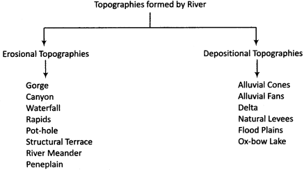
1. Erosional Topographies:
(a) Gorge:
A narrow valley between hills or mountains, typically with steep rocky walls and a stream running through it.
(b) Canyon:
Canyon is a narrower and deeper valley as compared to a gorge.
(c) Waterfall:
Waterfall is formed by sudden and rapid fall of water upon a steep slope.
(d) Rapids:
That part of course of river, where the river bounces while flowing due to the projected solid rocks, are known as rapids.
(e) Pot – hole:
These are troughs formed by the process of drilling carried out by water flow in the bottom of the river.
(f) Structural Terrace:
These are staircase – type topographies formed from alternate horizontal layers of hard and soft rocks in the flank of the valley.
(g) River Meander:
These are excessively circuitous turns of the river where it appears to flow like a snake.
(h) Peneplain:
This is a shapeless plain of less slope formed by the river.
2. Depositional Topographies:
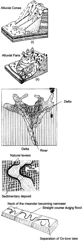
(a) Alluvial cone:
This is the cone – shaped deposit of debris on the mountainous slope formed where a river enters into the plains from the mountains.
(b) Alluvial fan:
These are fan – shaped deposit of debris when the river enters into the plains from the mountains.
(c) Delta:
Triangular region formed by alluvial deposit on the river estuary is known as delta.
(d) Natural levees:
These are walls of sandy soil formed on both the sides of the river after the water subsides down.
(e) Flood plains:
That part of the river where it deposits alluvium during flood time is known as flood plain.
(f) Ox – bow Lake:
After a long period of time, the meander becomes very curved, and eventually the neck of the meander becomes narrower and the river cuts through the neck during a flood, cutting off the meander and forming an oxbow lake.
Question 2.
Describe the topographies formed by glaciers.
Answer:
In high latitudinal regions or high relief regions, due to less- temperature, process of glaciation takes place. Presence of glaciers in such regions is a common phenomenon. Glacier is such stock of ice, which gradually shifts from its original place on the earth’s surface. In snow – covered regions, glaciers erode the rocks while performing corrasion and attrition and deposit moraines in various forms. Through these processes, two types of topographies are formed:
- Erosional topographies,
- Depositional topographies.
Both these types of topographies have been described in the following form:
1. Erosional Topographies:
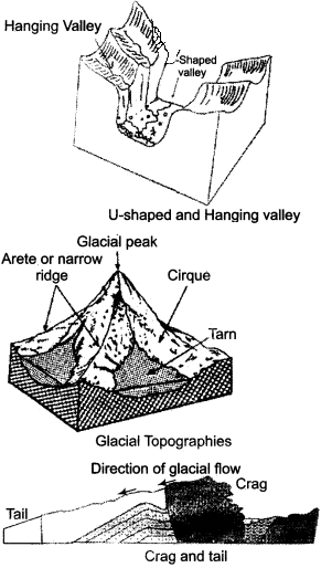
(a) U – Shaped valley:
U – shaped valleys are formed when a glacier travels across and down a slope, carving the valley by the action of scouring.
(b) Hanging valley:
In the U – shaped major deep valley, its assisting glacier valley appears to be hanging above it.
(c) Cirque:
This is an easy – chair – shaped trough formed by the glacier.
(d) Tarn:
This is a lake formed by filling up of water in the cirque basin.
(e) Nunatak:
Projected mounds in glacial regions are known as nunataks.
(f) Col:
This is a traverse path formed by the conjunction of two adjacent cirques.
(g) Crag and Tail:
A rocky outcrop with a tapering ridge of glacial deposits extending to one side is known as crag and tail.
(h) Sheep rock:
This is a sheep-back shaped rock formed by glacial erosion.
(i) Fiord:
These are scraped coasts formed by glaciers due to submergence of valleys.
2. Depositional Topographies:
(a) Moraine:
Deposits of pebbles, stones and boulders deposited by glaciers are known as moraines. These get deposited on the sides, back or bottom of the glacier.
(b) Esker:
These are long, narrow and wavy ridges formed by the deposit of glacial alluvium.
(c) Kame:
These are steep – sloped mounds formed by glacial alluvium.
(d) Kettle:
These are troughs formed by melting of glaciers.
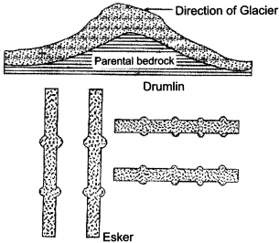
(e) Drumlin:
Egg – basket shaped structure formed by deposit of boulder bodies is known as drumlin.
(f) Glacial outwash plains:
These are fan – shaped plains formed by the spread of debris to distant places due to flow of glacial water.
Question 3.
Explain the term erosion and describe various topographies formed by its major factors.
Answer:
Erosion is a dynamic process. A transportation process included in the exogenetic forces produced on the earth’s surface transforms a projected land part into finally a leveled plain part. The word ‘Erosion’ has originated from the Latin word ‘Erodore’, which means scrubbing or nibbling.
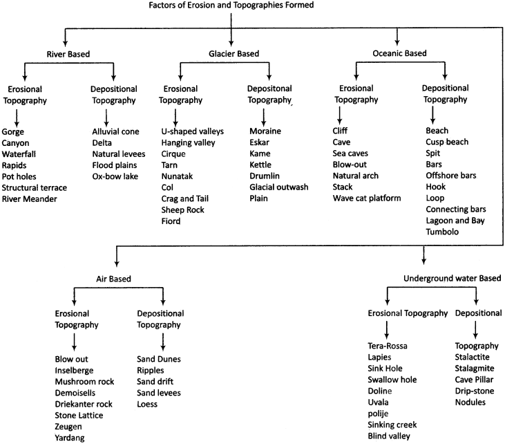
Factors of Erosion:
Factors of erosion refer to the forces and agents like river flow and oceanic waves, winds, underground water and glaciers which participate in the process of erosion. All these factors perform levelling of relief forms created by exogenetic forces on a land part. It is not essential for all the factors to remain equally active in the process of erosion. Above is the description of topographies formed by all these factors of erosion.
It is clear from the above table that there are five major components of erosion. All these five components form mainly two types of topographies:
- Erosional topography.
- Depositional topography.
Among both these types of topographies, erosional topographies are formed by erosion while depositional topographies are formed by deposition.
RBSE Class 11 Physical Geography Chapter 10 Other Important Questions
RBSE Class 11 Physical Geography Chapter 10 Multiple Choice Questions
Question 1.
Erosion is a/an:
(a) Dynamic process
(b) Static process
(c) Cyclic process
(d) None of the above
Answer:
(a) Dynamic process
Question 2.
Which of the following is a river – based topography?
(a)Esker
(b) Cliff
(c) Yardang
(d) Ox – bow Lake
Answer:
(d) Ox – bow Lake
Question 3.
A river based topography is:
(a) Kame
(b) Canyon
(c) Loop
(d) Zeugen
Answer:
(b) Canyon
Question 4.
Natural arch is a:
(a) Sea wave based topography
(b) Wind based topography
(c) Glacier based topography
(d) River based topography
Answer:
(a) Sea wave based topography
Question 5.
A sea based depositional topography is :
(a) Stack/cave pillar
(b) Blow out
(c) Tumbolo
(d) Waterfall
Answer:
(c) Tumbolo
Question 6.
A wind – based topography is:
(a) Sea cave
(b) Loop
(c) Driekanter rock
(d) Tera Rossa
Answer:
(c) Driekanter rock
Question 7.
A glacial topography is:
(a) Demoisells
(b) Lapies
(c) Nodules
(d) Cirque
Answer:
(d) Cirque
Question 8.
Which of these is not an underground water-based topography?
(a) Uvala
(b) Stalactite
(c) Mushroom rock
(d) Swallow hole
Answer:
(c) Mushroom rock
Question 9.
Red and brown soils formed by the process of oxidation in limestone regions is known as:
(a) Lapies
(b) Tera Rossa
(c) Uvala
(d) Dripstone
Answer:
(b) Tera Rossa
Matching Type Questions
Question 1.
Match column A to column B in the following:
| Column A (Topography) | Column B (Factor of Topography) |
| (i) Inselberge | (a) Underground water based |
| (ii) Cave | (b) Air based |
| (iii) Rapids | (c) Glacier based |
| (iv) Drumlin | (d) Ocean waves based |
| (v) Stalagmite | (e) River based |
Answers:
- (b)
- (d)
- (e)
- (c)
- (a)
Question 2.
Match column A to column B in the following :
| Column A (Topography) | Column B (Factor of Topography) |
| (i) River meander | (a) Air based |
| (ii) Loop | (b) Underground water based |
| (iii) Stone lattice | (c) Water running based |
| (iv) Doline | (d) Glacier based |
| (v) Paternoster Lake | (e) Sea wave based |
Answers:
- (c)
- (e)
- (a)
- (b)
- (d)
RBSE Class 11 Physical Geography Chapter 10 Very Short Answer Type Questions
Question 1.
How are topographies formed on the surface of the earth?
Answer:
On the earth’s surface, topographies are formed by the mutual action of exogenetic and endogenetic forces.
Question 2.
Who performs the work of denudation?
Answer:
Exogenetic forces perform the work of denudation in the form of weathering, erosion and mass translocation.
Question 3.
Which are the factors of erosion?
Answer:
River (Running water) sea waves, winds, glaciers and underground water are included in the factors of erosion.
Question 4.
What is a canyon?
Answer:
Canyon is a comparatively narrower and deeper valley than a gorge which is formed by river water.
Question 5.
What is meant by waterfall?
Answer:
Waterfall refers to the process of sudden and rapid fall of water upon a steep slope.
Question 6.
What is a river meander?
Answer:
In its course, the river flows in circuitous form according to the surface slope. This type of circuitous or snake – type flow of the river is known as river meander.
Question 7.
What is a peneplain?
Answer:
Leveled land form which is formed by transformation of topographies built by endogenetic forces into extreme lowland by the action of winds, glacial, rivers and sea waves is known as peneplain.
Question 8.
Write the names of depositional topographies formed by rivers.
Answer:
Alluvial cone, alluvial fan, delta, natural levees, flood plains and Ox – bow Lake are included in depositional topographies formed by rivers.
Question 9.
What is a delta?
Answer:
Triangular structure formed by deposition of alluvium on the estuary of river is known as delta.
Question 10.
What is a flood plain?
Answer:
That part of the river where the river deposits alluvium at the time of floods. The land part formed by flood in this manner is known as flood plain.
Question 11.
Which are the erosional topographies formed by sea waves?
Answer:
Erosional topographies formed by the sea waves include cliff, cave, sea cave, blow outs, natural arch, stack/cave pillars, wave cat platform, etc.
Question 12.
What is a cave?
Answer:
Egg – shaped structures formed by the erosion of tender rocks in regions of solid and tender rocks situated parallel to the shore are known as caves.
Question 13.
What is a stack?
Answer:
Pillar which is formed due to the breaking down of the ceiling of a natural arch is known as cave pillar or stack.
Question 14.
What is meant by cusp beach?
Answer:
Triangular beach formed from pebbles, stones, boulders, etc. which extends vertically towards the sea is known as cusp beach.
Question 15.
What is offshore bar?
Answer:
Dam or wall built at a distant place from the shore but parallel to it is known as offshore bar.
Question 16.
What is connecting bar?
Answer:
Dam or wall which joins two islands in the oceanic region is known as connecting bar.
Question 17.
Arid topographies are the result of which processes?
Answer:
Topographies formed in desert regions are the result of transportation, corrasion, attrition and deposition of debris.
Question 18.
What are blow outs?
Answer:
Those troughs which are formed by loose and disorganised terrain or rock parts blown and carried away by the wind are known as blow outs.
Or
Answer:
Mound of solid rocks found in desert region which survives the process of erosion is known as inselberge.
Question 19.
What is meant by zeugen?
Answer:
Zeugens are holes in desert regions formed by erosion of wind in the layers of hard and soft rocks spread alternately in Inkpot form.
Question 20.
Describe the topographies formed by wind deposition.
Answer:
Sand dunes, ripples, sand drift, sand levees and loess are formed by the deposition of soil blown by the wind in desert regions.
Question 21.
What is meant by sand dunes?
Answer:
Sand dunes are moving mounds of sand formed by the deposition of soil blown by the wind in desert regions. These mounds continue to shift according to the wind.
Question 22.
How are glacial topographies formed?
Answer:
In glacial regions, glacial topographies are formed by plucking, repulsion, attrition and glacial deposition.
Question 23.
Which are the glacial deposition topographies?
Answer:
Glacial deposition topographies include moraine, esker, kame, kettle, drumlin and glacial out wash plains.
Question 24.
What is underground water?
Answer:
Water present in the holes and cracks of underground rocks situated below the upper surface of the earth is known as underground water.
Question 25.
What is meant by karst region?
Answer:
The term ‘karts’ has originated from the Yugoslavian word ‘Krass’ which means the region of lime. This lime region itself is known as karts region.
Question 26.
Write the names of erosional topographies formed in Karts regions.
Answer:
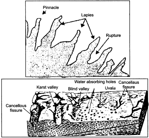
Erosional topographies formed in karts regions include Tera Rossa, lapies, sink hole, swallow hole, doline, uvala, polije, sinking creek and blind valley.
Question 27.
Which are the depositional topographies formed in Karts regions?
Answer:
Depositional topographies formed in Karts regions include stalactite, stalagmite, cave pillar, drip stone and nodules.
Question 28.
What is meant by sinking creek?
Answer:
Innumerable holes or pores on the surface of lime from where water appears to be sinking are known as sinking creeks.
Question 29.
What are nodules?
Answer:
Deposits of a type of mineral oil derived from rock holes is known as nodules.
RBSE Class 11 Physical Geography Chapter 10 Short Answer Type Questions (SA-I)
Question 1.
Explain the importance of the components of erosion.
Answer:
Erosion is a dynamic process. Forces such as river, sea waves, winds, glaciers and underground water which participate in the process of erosion are known as components of erosion. It is not essential that all these components participate in the process of erosion in an equal measure or at an equal rate, because the climatic condition of a particular region influences the structure and composition of rocks. If these components of erosion were not present, then the surface would always be dissimilar which would be an undesirable condition.
Question 2.
What is the difference between alluvial cone and alluvial fan?
Answer:
Following differences are found between alluvial cone and alluvial fan:
| Alluvial Cone | Alluvial Fan |
| 1. Slope is found to be more in alluvial cone. | 1. Slope is found less in alluvial fan. |
| 2. This is the triangular deposit of debris on mountainous slope which is formed when the river enters from the mountains into the plains. | 2. This is fan – shaped deposit of debris formed when the river enters from the mountains into the plains. |
| 3. Channels are less-divided in case of alluvial cone. | 3. In case of alluvial fan, channels get divided into many parts. |
Question 3.
What are wind based topographies?
Answer:
In desert regions, various topographies are formed by the erosional and depositional activities of winds. In desert regions, winds perform evulsion, corrasion, attrition and cut and sort the rocks and transport the rock particles and deposit them at other places. Erosional and depositional activities take place through all these processes in desert areas by the action of winds. The topographies formed by action of winds in arid regions are:
Erosional Topographic:
Blow outs, inselberge, mushroom rocks, demoisells, driekanter, stone lattice, zeugen, yardang etc.
Depositional Topographies:
Sand dunes, ripples, sand drifts, sand levees, loess etc.
Question 4.
Explain the term ‘sand dunes’.
Answer:
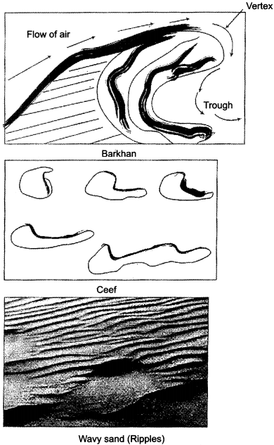
Through erosion and deposition, wind erodes soil from one place and deposits it at another place. This task of deposition becomes possible in exceptional conditions only. Sand dunes are mostly formed in arid and semiarid regions. Difference on regional basis is found in the shape and form of sand dunes.
There shape may be circular, crescent or parabolic. Their height may also vary from a few meters up to 20 meters. Significant difference is also there in slopes on both the sides of sand dunes. They are divided into traversal, parabolic and longitudinal sand dunes.
Question 5.
What is the difference between, alluvial plains and moraine plains?
Answer:
Following are the differences found between alluvial plains and moraine plains:
| Alluvial Plains | Moraine Plains |
| 1. These type of plains are formed by deposition of running water. | 1. These types of plains are formed by glacial deposition. |
| 2. Alluvial plains are plains of alluvial soil. | 2. Glacial plains are formed by ice. |
| 3. As the alluvial plains are formed by soil deposited by rivers, they are fertile from agricultural point of view. | 3. As the glacial plains are formed of ice, they are not fertile. |
Question 6.
What is meant by karts (limestone) topographies?
Answer:
Water present in the holes and cracks of underground rocks situated below the upper layer of the earth is known as underground water. In regions of limestone rocks, various types of land forms are built by underground water, through the oxidation process, above and below the surface. Lime region is known as karts region.
The word ‘karts region’ has originated from the word ‘Krass region’ from Yugoslavia. On the basis of this name, topographies formed in limestone regions are known as karts topographies in all the countries of the world. Topographies formed in these regions are known as karts topographies.
Question 7.
What is the difference between sink hole and swallow hole?
Answer:
Following are the differences between sink hole and swallow hole:
| Sink Buie | Swallow Hole |
| 1. These are small in size. | 1. These are large in size. |
| 2. They are formed by active oxidation of carbon dioxide with water. | 2. These are formed by the mutual conjunction of sink holes. |
| 3. Sink holes are found in larger amount in lime regions. | 3. Swallow holes are less in number. |
Question 8.
What is the difference between pinnacle and fissure?
Answer:
Due to the process of erosion in lime regions, pointed and thorny topographies are formed, which are known as lapies. The extreme ridges or pointed parts of these lapies are known as pinnacles. The hole – type parts found between these extreme ridges or pointed parts are known as fissures.
RBSE Class 11 Physical Geography Chapter 10 Short Answer Type Questions (SA-II)
Question 1.
Describe the depositional topographies formed by river.
Answer:
Following are the depositional topographies formed by flowing water:
1. Alluvial Cone:
This refers to the cone – shaped deposit of debris which takes place when the river enters from the mountains into the plains.
2. Alluvial Fan:
This refers to fan – shaped deposit of debris which takes place when the river enters from the mountains into the plains.
3. Delta:
Triangular – shaped deposit formed by alluvial deposit on the estuary of the river is known as delta.
4. Natural Levees:
After the water subsides, the walls of sandy soil formed on both the sides of river are termed as natural levees.
5. Ox – bow Lake:
When the. river shuns its watercourse and flows straight, its curved parts fill up with water and form Ox – bow Lakes.
Question 2.
Describe the depositional topographies formed by wind.
OR
In desert regions, which are the topographies formed by the deposition of sand?
Answer:
Desert regions exhibit lack of moisture due to excessive temperature. The impact of air is more in regions of less moisture. Topographies which are formed by the deposition of soil blown and brought by air are known as depositional topographies. Some of the major topographies formed by deposition performed by wind are as follows:
1. Sand dunes:
These are tiny moving piles or mounds of sand, which get shifted along with wind.
2. Ripples:
These are structures which get projected on the sandy surface of the deserts, just like sea waves.
3. Sand drifts:
These are moving vertical sequences of sand on the edge of the topographic obstacle.
4. Sand levees:
These are vertical sequences of sand with broad peak.
5. Loess:
Deposit of minute sand particles flown and brought by the wind are known as loess.
Question 3.
Clarify the difference between Uvala and Polije.
Answer:
Following are the differences found between these topographies:
| Uvala | Polije |
| 1. Uvalas are formed by conjunction of many dolines due to the continuous process of oxidation. | 1. Polijes are formed due to changes taking place in faults and concave part below the limestone rocks through the process of oxidation. |
| 2. The diameter of uvalas is usually about 1 km. | 2. Diameter of polijes is spread over many square kilometres. |
| 3. Its walls are vertical and are joined at the upper edge. | 3. Its bottom or ground is leveled and its walls are vertical. |
Question 4.
Clarify the terms stalactite and stalagmite.
Answer:
Stalactite and stalagmite both are topographies formed by the process of under ground water deposition in lime regions. Both these topographies are the result of the process of oxidation of lime in water. Structure of both these topographies and the differences between them has been depicted in the following way:
| Stalactite | Stalagmite |
| 1. This topography develops besides the upper ceiling of the sea cave in lime regions. | 1. This topography is formed at the ground or lowest edge of the sea cave in lime regions. |
| 2. This topography hangs downwards from the upper side of the sea cave. | 2. This topography projects upwards from the lowest edge of the sea cave. |
| 3. Its pointed part is inclined downwards. | 3. Its pointed part elevates upwards. |
| 4. This topography forms due to vaporization of water leaking out of the ceiling. | 4. This topography is formed by the falling down of hanging moist lime due to gravitational force. |
RBSE Class 11 Physical Geography Chapter 10 Essay Type Questions
Question 1.
Describe the topographies formed by sea waves.
Answer:
Ripples that rise on the surface of the sea due to the movement of air are known as waves. In coastal regions, waves form many types of erosional and depositional topographies by the process of hydrolysis, corrasion, attrition and hydraulic pressure and by deposition of debris. Following is their description:
1. Erosional Topographies:
(a) Cliff:
Erosion which takes place due to the continuous impact of the waves on the base forms a steep slope which is known as cliff.
(b) Cave:
Egg – shaped structure formed by the erosion of tender rocks in regions of hard and soft rocks situated parallel to the shore is known as cave.
(c) Sea cave:
Due to continuous erosion of gorges formed by waves in coastal regions, sea caves are formed.
(d) Blow outs:
Sea waves form holes on the ceiling of the coastal caves which are known as blow outs.
(e) Natural arch:
Mutual conjunction of caves formed from two sides on the coast result into the formation of natural arch.
(f) Stack/Cave pillar:
Pillar which is formed due to the breaking down of the ceiling of a natural arch is known as cave pillar or stack.
(g) Wave cat platform:
This is platform built due to the cliff continuously shifting backwards.
2. Depositional Topographies:
(a) Beach:
Beaches are formed due to deposit of debris by the waves on the edges of the seashore.
(b) Cusp Beach:
Triangular beach formed from pebbles, stones, boulders, etc. which extends vertically towards the sea is known as cusp beach.
(c) Spit:
Deposit made by waves in the form of tongue towards the sea is known as spit.
(d) Bars:
Ridges or dams formed from deposition performed by waves are known as bars.
(e) Offshore bars:
Dam or wall built parallel to the coast but far away from it is known as offshore bar.
(f) Hook:
Crescent circuitous deposit of spit is known as hook.
(g) Loop:
When the hook turns towards the hoop, a loop-shaped structure is formed.
(h) Connecting Bars:
Dam, ridge or wall which joins two islands are known as connectors or connecting bars.
(i) Tumbolo:
Bars which connect the islands with the shore are known as tumbolos.
These depositional topographies are shown with the help of diagram:
Question 2.
Describe the topographies formed by wind.
Answer:
In desert regions, various topographies are formed by the erosional. and depositional activities carried out by the winds. Through the activities of transportation, corrasion and attrition, winds cut and sort the rocks and carry the rock particles, depositing them at other places due to which various topographies are formed in desert regions by these erosional and depositional activities of winds. Following is the description of these topographies:
1. Erosional Topographies:
(a) Blow out:
Those troughs which are formed by loose and disorganized terrain or rock parts blown and carried away by the wind are known as blow outs.
(b) Inselberge:
These are projected dunes of solid rocks in the desert-like large seas, and they appear to be like an island or a mountain.
(c) Mushroom Rock:
These are residual parts of solid rocks which resemble an umbrella in shape.
(d) Demoisells:
Those surface columns in deserts which are protected with cover of solid rocks or terrain are known as demoisells.
(e) Driekanter Rock:
A Dreikanter rock is a type of ventifact that typically forms in desert or periglacial environments due to the abrasive action of blowing wind.
(f) Stone Lattice:
This is a reticulated rock which is formed by the process of corrasion by the wind upon rocks with different compositions.
(g) Zeugen:
These are gorges formed by erosion of wind in the layers of hard and soft rocks spread alternately in horizontal form.
(h) Yardang:
These are pointed, earth – shaped structures formed by respective vertical layers of hard and soft rocks.

2. Depositicfnal Topographies:
(a) Sand Dunes:
These are small moving piles or mounds of sand, which get transported along with the wind.
(b) Ripples:
These are land forms which emerge on sandy surface of the desert just like oceanic waves.
(c) Sand Drifts:
These are vertically moving guilds of sand, situated on the edge of topographical obstruction.
(d) Sand Levees:
These are vertical guilds of sand with a broad peak.
(e) Loess:
Deposit of very fine dust particles brought by blowing wind is known as loess.
These depositional topographies formed by wind in arid regions are depicted with the help of the following diagrams.
Question 3.
Describe the topographies formed by underground water.
Answer:
Water present in the holes and cracks of underground rooks situated below the upper surface of the earth is known as underground water. In limestone regions, various topographies are formed by underground water above and below the surface due to the process of oxidation. The word ‘Karst’ has originated from the Yugoslavian word ‘Krass’, which means lime region.
The word ‘karts region’ has been taken from the Yugoslavian word ‘krass region’. On the basis of this name, topographies formed across all the limestone regions in the countries of the world are known as karst topographies. Here, various topographies are formed by erosional and depositional activities. Following is a description of these topographies :
1. Erosional Topographies:
(a) Tera Rossa:
Red and brown soils formed by oxidation are known as Tera Rossa.
(b) Lapies:
These are pointed and thorny topographies which resemble lake beds.
(c) Sink – Hole:
These are troughs formed by the process of oxidation of limestone by water containing carbon dioxide. Swallow holes and dolines are also the same type of troughs, but they are comparatively larger in size.
(d) Swallow – Hole:
These holes are bigger in size as compared to sink holes.
(e) Doline:
Holes that are bigger in size or bigger in shape are known as dolines.
(f) Uvala:
These are expansive troughs formed by the mutual conjunction of various dolines.
(g) Polije:
These are expansive and larger-sized troughs formed by the conjunction of many uvalas.
(h) Sinking Creek:
Innumerable holes or pores on the edge of lime, from where water appears to be sinking are known as sinking creeks.
(i) Blind Valley:
In lime region, the flowing river goes underground from doline and other holes due to which the valley which lies beyond that remains arid. It is known as blind valley.
These erosional topographies situated in karts regions have been depicted through the following diagrams:
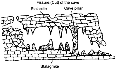
2. Depositional topographies:
(a) Stalactite:
This is a solid and pointed structure hanging from the ceiling of caves. It is formed from the vaporization of water leaking out of the ceiling.
(b) Stalagmite:
This is a pillar – shaped structure formed on the ground of the cave. It is formed by the water dripping on the ground.
(c) Cave Pillar:
This is a pillar – shaped structure formed by the conjunction of stalactite and stalagmite.
(d) Drip – Stone:
This is a lime pillar which resembles a curtain. It is situated at the bottom of the cave.
(e) Nodules:
Deposit of a type of mineral oil derived from rock holes is known as nodules.
All these depositional topographies have been depicted with the help of the following diagram: