Rajasthan Board RBSE Class 11 Physical Geography Chapter 12 Insolation and Heat Budget
RBSE Class 11 Physical Geography Chapter 12 Text Book Questions
RBSE Class 11 Physical Geography Chapter 12 Multiple Choice Questions
Question 1.
The insolation is measured by an instrument called:
(a) Pyroheliometer
(b) Thermometer
(c) Barometer
(d) Centimeter
Answer:
(a) Pyroheliometer
Question 2.
How long do the sun rays take to reach the earth?
(a) 5 minutes
(b) 6 minutes
(c) 7 minutes
(d) 8 minutes
Answer:
(d) 8 minutes
Question 3.
The solar energy coming to Earth is called:
(a) Terrestrial radiation
(b) Solar radiation
(c) Insolation
(d) Heat budget
Answer:
(c) Insolation
Question 4.
The meaning of inversion of temperature is:
(a) Increase of temperature on the surface
(b) Uneven fall in temperature
(c) Temperature rise along with height
(d) Temperature decrease along with height
Answer:
(c) Temperature rise along with height
Question 5.
How much of the total solar radiation reaches on the earth?
(a) 51%
(b) 48%
(c) 35%
(d) 17%
Answer:
(a) 51%
RBSE Class 11 Physical Geography Chapter 12 Very Short Answer Type Questions
Question 1.
What is solar radiation?
Answer:
The radiation that is emitted from the surface of the Sun is called solar radiation.
Question 2.
What are Isotherms?
Answer:
Isotherms are such imaginary lines that are drawn to join the places with equal temperature on the map.
Question 3.
What is the distance of the earth from the sun?
Answer:
The average distance of the Earth from the Sun is 15 million kilometers.
Question 4.
What is meant by arbitrariness?
Answer:
Distribution of temperature on the surface of the earth is not the same, but it varies. This variation in temperature is called ‘arbitrariness’ in context to different places.
Question 5.
What is the main source of atmospheric heating?
Answer:
Sun is the main source of atmospheric heating.
RBSE Class 11 Physical Geography Chapter 12 Short Answer Type Questions
Question 1.
What is meant by Earth’s Albedo?
Answer:
When rays of light fall on any surface, some part them it gets reflected in accordance with the rules of reflection. This process is called reflection of light. This amount of reflection depends on the smoothness of the surface. The ratio of the amount of radiation reflected back to space, to the incident radiation (insolation) is called the Earth’s Albedo. Generally, the process of reflection of the sunlight received by the surface is called Albedo.
Question 2.
What is meant by inversion of temperature?
Answer:
There is decrease in temperature in troposphere, the lower most layer of the atmosphere, when one proceeds upwards to greater height from the surface of earth. But sometimes, in some special circumstances, the temperature increases with elevation rather than decreasing. This process of temperature rise along with increase in height is called temperature inversion. For thermal inversion, factors like prolonged nights, clear skies, calm air, dry air and glacial conditions are factors considered to be responsible.
Question 3.
What is the meant by insolation?
Answer:
The word insolation means ‘sol’, i.e. Sun and ‘in – ation’, which means coming in. On this basis, solar radiation received from the Sun by the Earth is called insolation. So solar radiation coming on the surface of earth is called insolation. The entire insolation does not reach the Earth’s surface, and only a fraction of it (two billionth part) reaches the earth.
Question 4.
What are the factors affecting insolation?
Answer:
The amount of insolation in a certain area varies according to weather and atmospheric conditions. The amount of temperature obtained from the Sun on the surface is influenced by the following factors:
1. Distance from the equator:
Sun rays are usually incident vertical at the equator, whereas, when we proceed towards the north and south direction, away from the equator, the rays are incident at a slanting angle, which has an effect on the insolation.
2. Height above sea level:
As the height increases, the temperature decreases.
3. Distance from the sea level:
In the regions near the ocean, the temperature is less, whereas in the inland parts, the temperature increases.
4. Sea currents:
According to the cold and hot water currents of the oceans, the temperature continues to be low or high.
5. Prevailing winds:
Winds increase or decrease the temperature according to their cold and warm nature.
6. Slope of land:
According to the front and opposite slope of land form facing towards or away from the sun there is variation in temperature.
7. Nature of the Surface:
Whether a region is forested or not or is glaciated or not has an impact on temperature.
8. Clouds and rainfall:
The position of clouds also acts as temperature controller.
Question 5.
What is the difference between the horizontal and vertical distribution of temperature?
Answer:
Horizontal distribution of temperature:
Horizontal distribution of temperature means the latitudinal distribution of temperature. In this, the temperature from the equator to the poles is divided on the basis of latitude. Under this, the distribution of temperature is represented by the isotherms on a map.
Vertical distribution of temperature:
The vertical distribution of temperature refers to the distribution of temperature in the various layers of the atmosphere, at different altitudes from the earth’s surface. The temperature normally decreases due to the elevation from the surface. The decrease in temperature is different at all places and it is not the same everywhere.
RBSE Class 11 Physical Geography Chapter 12 Essay Type Questions
Question 1.
What is meant by insolation? Describe the factors affecting the distribution of temperature.
Answer:
Solar radiation reaching the Earth from the Sun is called insolation. Acquisition of solar radiation by the Earth is called the reception of insolation. So solar radiation coming to the surface is called insolation.
1. Distribution of temperature:
The distribution of temperature are is not the same on the entire surface area of earth in context to weather and atmospheric conditions. The following factors are responsible for this unequal distribution of temperature:
2. Distance from the equator:
Sun rays fall almost vertically the whole year round on the equator because of which there is more sunlight over there. On the contrary, when we proceed in the direction from the equator towards the poles, the rays of the Sun become tilted. So there is less sunlight there. The temperature on the poles goes even below the freezing point and they always remain covered with snow.
3. Height from sea level:
Highest temperature is found at the sea level. The temperature decreases while proceeding upwards from the earth’s surface to a height. Usually, at a height of 165 meters, the temperature drops to 1°C or there is a decline of 6.4°C in temperature for an altitude of 1 km. Shimla has less temperature than Delhi because Shimla is located at a higher altitude than Delhi. Therefore, the mountainous regions are colder than the plains.
4. Distance from the sea:
In comparison to land, water takes more time to get heated up and to cool down. Therefore, at places that are near the ocean, the temperature remains almost the same. On the contrary, there is more variation in the temperature of the places located inland, away from the sea.
5. Sea Currents:
Sea Currents significantly affect the temperature of coastal areas. In the areas where the hot currents flow, the temperature is high, and in the areas where cold stream flows, the temperature is less. The hot current of ‘Gulf Stream’ maintains high temperatures in the coastal parts of Europe. Thus, sea currents control the temperature of the coastal areas according to their nature.
6. The Prevailing wind:
Where the hot winds blow, the temperature is high and when the cold winds blow the temperature is less. The ‘Sirocco’ wind blowing from the Sahara Desert in Italy and the hot winds called ‘Chinook’ blowing in the North American plains, cause an increase in temperature over there. Similarly, due to the Loo blowing in summers in the plains of Northern India, sometime the temperature increases up to 45°C.
7. Slope of Land:
The gradient of the surface that comes in front of the sun receives more sunlight, so there is more temperature. On the contrary, on the slopes which are in the opposite direction from the sun, there is less sunlight, and there is also less temperature. The temperature is high on the southern slopes of the Himalayas and Alps, and temperatures is lower on the northern slopes.
8. Nature of the surface:
The surface covered with snow and vegetation reflects most of the heat received from the sun. Therefore, the temperature in these regions is not high. On the contrary, the regions covered with sand and black soil absorb most of the insolation due to which the temperature is high over there. The process of reflection of the sun’s heat received by the surface is called ‘Albedo’.
9. Clouds and Rain:
Those areas on the land where clouds are present, the rainfall is high. The temperature does not increase as the clouds reflect back the sun’s rays. Like, despite the sun’s rays falling vertical on the cloudy equatorial regions, it does not get as heated up as it gets in the hot desert areas.
Question 2.
Explain the Heat Budget of Earth.
Answer:
The meaning of the heat budget of earth:
The heat budget refers to the heat received by the Earth and the atmosphere and the balance of heat loss by the earth. The greater capacity of heating of the Earth, the greater is the amount of heat energy returned back into space by radiation.
The budget of heat:
The Earth gets the solar radiation from the Sun in the form of short waves. After colliding with the Earth, reflection of the solar radiation takes place. The returning radiation from the Earth is called Terrestrial Radiation, which is in the form of long waves. Thus, the amount of solar radiation received by the earth and the terrestrial radiation released by the earth is almost the same.
Earth can receive only 1 part of the sun’s total energy from two billion parts of the incoming solar insolation. The rest is dissipated due to the absorption, reflection and scattering by the atmosphere. As long as the amount of solar radiation and earth’s natural radiation remains equal, it is called a balanced heat budget. Due to the increasing role of human action, the quantum of Terrestrial Radiation is gradually decreasing, due to which the temperature of the earth has started gradually increasing.
If we assume that 100 units is the heat received by the upper boundary of the atmosphere, then the budget formed will be:
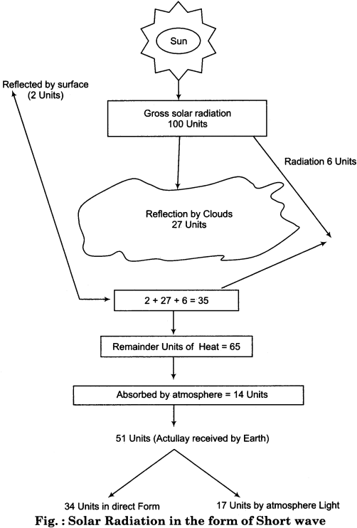
Receipt of solar radiation by Earth:
If there is 100 units of heat coming from the Sun, 27 units of them are reflected by the clouds and 2 units of heat are reflected by the surface whereas 6 units are dispersed by the atmosphere. Thus, there is no role of 35 units of heat in heating the earth. Of the remaining 65 units, 14 units are absorbed by thermal conductivity (water vapor, dust particles).
Thus, only 51 units of heat reaches on the Earth. Apart from this, only 34 units of heat are received directly by the earth, the remaining 17 units are received by the earth through atmospheric light. This form of solar radiation obtained by the Earth has been clarified with the diagram given above.
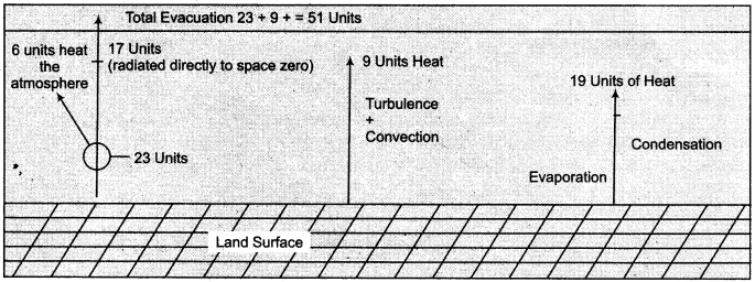
Earth’s process of Terrestrial Radiation:
Earth receives 51 units of solar radiation which return as Terrestrial Radiation. Out of this 51 units of heat, 23 units are radiated in the form of long waves from the thermal surface, out of which 17 units of heat goes directly to space, while 6 units heat the atmosphere with effective radiation.
9 units are spent in the form of heat convection and disturbance and the remaining 19 units are spent in the process of earth evaporation and compaction. Thus the earth returns all the 51 units of heat. This form of terrestrial radiation is represented by the following diagram:
Question 3.
Explaining the distribution of temperature, clarify horizontal and vertical distribution of temperature on the globe.
Answer:
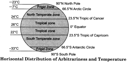
Distribution of temperature on the earth’s surface is not even everywhere. Therefore, the distribution of temperature has the maximum effect of latitudes as compared to other factors. Based on the temperature, the world is divided into three zones. There is a close connection between insolation and temperature. The distribution of heat is mainly divided into two types:
1. Horizontal distribution of temperature:
The horizontal distribution’ of temperature means the latitudinal distribution of temperature. There is change in the distribution of temperature from the equator to the poles. The temperature distribution on the map is represented by the isotherms. In most parts of the world, minimum and maximum temperatures are found in the months of January and July. Therefore, for analyzing temperature, the months of January and July are usually chosen.
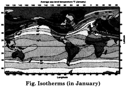
Isotherms of January:
In January, the sun rays fall vertically on the Tropic of Capricorn in the southern hemisphere, due to which the southern hemisphere has summer season and the northern hemisphere has winter season. Therefore, the temperature in the southern hemisphere is high and the temperature in the northern hemisphere is low.
Meanwhile, the coldest parts are located in Siberia and Greenland. The isotherms of 25°C are stretched over the vast area of Siberia. On the southern continents, the isotherms of 30°C and in the southern hemisphere the isotherms of 10°C are parallel to the latitudes, while the isotherm of 20°C is a twisted line according to the distribution of continents and oceans. Isotherms have been made quite curved due to the uneven distribution of water and land in the Northern Hemisphere.
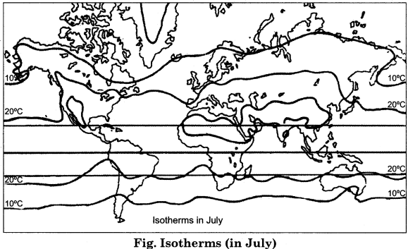
Isotherms of July:
In July, the rays of the sun shine almost vertically on the Tropic of Cancer in the northern hemisphere. Thus, in the northern hemisphere there is summer season and in the southern hemisphere there is winter season. In July, the isotherm of 30°C is enclosed in North Africa, the South – Western and Central Asia, and the Columbia Plateau in North America.
In comparison with the isotherms of January, it is clear that the effect of summer is on more areas in July. During this time, there is minimal temperature in Antarctica. The isotherms in the southern hemisphere have often been drawn parallel to the axes latitudes.
2. Vertical distribution of temperature:
By the vertical distribution of temperature we mean the distribution of temperature, in different layers of the atmosphere above the earth’s surface, at different altitudes. Scientists have proven it on the basis of facts that the temperature decreases as the height increases. This is the reason that the hills are colder than the plains.
There is a decrease of 1°C in temperature at a height of every 165 meters, which is called normal temperature lapse rate. This rate is not the same at every place, but according to the season, condition and local turbulence, it keeps changing. Normally, the temperature decreases at a rate of 6.4°C per km. The decline in temperature continues till the troposphere. After this, the decrease of temperature stops.
RBSE Class 11 Physical Geography Chapter 12 Other Important Questions
RBSE Class 11 Physical Geography Chapter 12 Multiple Choice Questions
Question 1.
What is the temperature of the surface of the Sun?
(a) 4000°C
(b) 5000°C
(c) 6000°C
(d) 7000°C
Answer:
(c) 6000°C
Question 2.
What is the distance of the sun from the Earth?
(a) 12 million km
(b) 13 million km
(c) 14 million km
(d) 15 million km
Answer:
(d) 15 million km
Question 3.
What is the main source of heat on the earth?
(a) Moon
(b) Sun
(c) Meteor
(d) Stars
Answer:
(b) Sun
Question 4.
Where is the most heat experienced?
(a) on the equator
(b) on the Tropic of Cancer
(c) on the Tropic of Capricorn
(d) on the Arctic Circle
Answer:
(a) on the equator
Question 5.
Into how many heat zones is the earth divided ?
(a) 2
(b) 3
(c) 4
(d) 5
Answer:
(b) 3
Question 6.
In the southern hemisphere, when do the rays of sun shine vertically on the Tropic of Capricorn?
(a) In March
(b) In March
(c) In June
(d) In May
Answer:
(a) In March
Question 7.
When does Antarctica have the minimum temperature?
(a) In January
(b) In May
(c) In July
(d) in June
Answer:
(c) In July
Question 8.
What is the normal lapse rate?
(a) 1°C at 165 meters
(b) 2°C at 265 meters
(c) 3°C at 550 meters
(d) 4°C at 765 meters
Answer:
(a) 1°C at 165 meters
Question 9.
Gulf stream current is:
(a) warm
(b) cold
(c) polar
(d) none
Answer:
(a) warm
Question 10.
How much of Terrestrial Radiation is released by convection?
(a) 17 units
(b) 6 units
(c) 9 units
(d) 19 units
Answer:
(c) 9 units
Matching Type Questions
Question 1.
Match column A with column B:
| Column A (Name of the imaginary line) | Column B (Latitudinal value) |
| (i) Equator | (a) 66\(\frac { 1 }{ 2 }\)° Southern latitude line |
| (ii) Tropic of Cancer | (b) 23\(\frac { 1 }{ 2 }\)° Southern latitude line |
| (iii) Tropic of Capricorn | (c) 23\(\frac { 1 }{ 2 }\)° Northern latitude line |
| (iv) Arctic circle | (d) 0° latitude line |
| (v) Antarctic Circle | (e) 66\(\frac { 1 }{ 2 }\)°Northern latitude line |
Answers:
- (d)
- (c)
- (b)
- (e)
- (a)
Question 2.
Match column A with column B:
| Column A (Condition) | Column B (Relation) |
| (i) Lesser temperature than freezing point | (a) Loo |
| (ii) Hot stream | (b) 27 per cent |
| (iii) Hot wind | (c) 14 per cent |
| (iv) Heat reflected by clouds | (d) Gulf Stream |
| (v) Total absorption by the atmosphere | (e) Polar regions |
Answers:
- (e)
- (d)
- (a)
- (b)
- (c)
RBSE Class 11 Physical Geography Chapter 12 Very Short Answer Type Questions
Question 1.
What protects the earth from heat?
Answer:
The envelope of thousands of kilometers of the atmospheric layers protects our Earth from the fierce rays of the sun and from its intense heat.
Question 2.
What is the sun?
Answer:
The sun is a very hot gaseous body, from which, continuous radiation of energy is emitted.
Question 3.
What does solar radiation mean?
Answer:
The radiation that is emitted from the surface of the Sun is called solar radiation.
Question 4.
What is the definition of insolation given by Critchfield?
Answer:
According to Critchfield, “The radiation energy reaching the earth from the Sun is called insolation”.
Question 5.
On the basis of temperature, earth has been divided into how many zones?
Answer:
On the basis of temperature, the earth has been mainly divided into torrid/tropical zone, temperate zone and frigid zone.
Question 6.
What is meant by temperature?
Answer:
Temperature depends on the insolation, so the atmospheric heat is expressed as temperature.
Question 7.
How is the distribution of temperature represented on the map?
Answer:
The temperature distribution is represented by the isotherms on the map.
Question 8.
Where are rays of Sun vertical in January?
Answer:
In January, the sun’s rays are vertical on the Tropic of Capricorn in the Southern Hemisphere.
Question 9.
Where do the rays of the sun fall vertically in the month of July?
Answer:
In July, the sun’s rays are vertical fall vertically on the Tropic of Cancer in the Northern Hemisphere.
Question 10.
What is the normal lapse rate of temperature?
Answer:
From the surface to various heights in the troposphere, at a height increase of every 165 meters, the temperature decreases by 1°C, which is called the normal lapse rate of temperature.
Question 11.
What are the ideal conditions for inversion of temperature?
Answer:
Long nights, clear sky, calm air, dry air and glaciated conditions are ideal for inversion of temperature.
Question 12.
Why is the temperature of Shimla found to be less than that of Delhi?
Answer:
Shimla is at a higher elevation than Delhi, and due to the increased altitude, the temperature of Shimla is less.
Question 13.
How do winds control heat ?
Answer:
The temperature is controlled by the movement of winds. In those areas where the hot winds blow, the temperature becomes high, whereas the temperature is less in those areas where cold winds blow.
Question 14.
How do the clouds control – temperature?
Answer:
In the areas where the clouds are present and where there is rain, the temperature is not high, because the clouds reflect the rays of the sun while there is more heat in the cloud – free areas;
Question 15.
What is meant by heat budget ?
Answer:
The heat budget refers to the heat received by the Earth and the atmosphere and the balance of heat loss in return.
Question 16.
Why does the sun’s entire heat not reach the ground?
Answer:
In the midst of the distance between the sun and the earth, there is the process of absorption, Reflection and scattering of the rays of the sun, due to which the sun’s rays do not reach the earth’s surface completely.
RBSE Class 11 Physical Geography Chapter 12 Short Answer Type Questions (SA-I)
Question 1.
Explain the utility of the atmosphere.
Answer:
The atmosphere is very important for the Earth, its importance has been explained through the following points:
- The envelope of thousands of kilometers thick atmosphere protects our earth from the intense heat of the sun.
- During the night time, it acts like a blanket and prevents us from severe cold.
- Gases present in the atmosphere are useful for humans.
- Ozone gas of the atmosphere protects us by preventing the harmful ultraviolet rays of the sun from entering the earth.
Question 2.
In January, clarify the position of the isotherms of the Northern Hemisphere.
Answer:
In January, the sun shines directly in the Southern Hemisphere. At this time’, the rays of the sun fall vertically on the Tropic of Capricorn, due to which the Southern Hemisphere has summer and Northern Hemisphere has winter season.
The isotherms in this period show the low temperature conditions in the Northern Hemisphere. A center of low temperature develops in the northern part of the Siaberian part of Asia. Here -30 °C isotherm line is found. Temperatures in the Southern part of North America, Southern Europe and south Asian part is depicted by the 10° – 20° isotherms.
Question 3.
Explain the isotherms of the Southern Hemisphere in January.
Answer:
In the month of January, the sun shines vertically on the Tropic of Capricorn in the Southern Hemisphere, due to which summer season is there in this hemisphere. In this hemisphere, the isotherms follow the latitudes, and in the far south, they surround the Antarctica continent from all the four sides continent. 0° centigrade isotherm proceeds from the South Polar Circle.
The isotherms of 10° and 20° centigrade temperature pass from the southern part of South America and southern parts of Australia The 20° isotherm crosses South America from southern Australia, crossing South – Western part of Africa and proceeds upwards after entering the ocean. The 40° isotherm follows approximately the 60° south latitudinal circle.
Question 4.
How does uneven distribution of temperature on earth affect the climate and weather?
Answer:
Different climatic regions are there due to uneven distribution of temperature on the earth’s surface. In the tropical parts, sun rays fall vertically throughout the year, due to which there is high temperature, hence in such parts the weather is hot all the year round and tropical climate is found there. In the temperate zone, there is relatively low temperature, the temperature decreases, the seasonal changes in these parts of the region are more and temperate climate is found.
Due to low temperature in high latitudes, snow is present for almost the entire year. So, the climate of such regions is polar. It is clear that the variation of temperature on the surface affects the weather and climate to the maximum amount.
Question 5.
Direct rays provide more insolation than slanted rays. Why?
Answer:
The angle of dip of sunrays plays an important role in influencing the quantity of insolation. The direct rays of the sun provide more insolation than the slant rays. This is because of the following two reasons:
1. The direct rays have to cross the narrower layer of the atmosphere, therefore less energy is destroyed in the atmosphere. While skewed rays cross the broader part of the atmosphere, so more energy is destroyed in the atmosphere.
2. The direct rays heat lesser part of the surface while the same amount of slant rays warm a greater area of the surface. Therefore, direct rays provide more insolation than slant rays.
Question 6.
The annual temperature range is highest in the plains of Siberia. Why?
Answer:
The expansive area of Siaberia is situated in the Northern part of Eurasia. Here continental type of climate is found. The temperature increases due to the Gulf stream water stream in the oceanic areas and the North Atlantic drift. These currents have very little effect in the inner part of the continent. Therefore, the temperature remains low in the inner part.
In winter, the temperature in most part of the ground falls even below 0°C. The lowest temperature of the world is recorded in this part. Thus, due to the effects of water bodies in the coastal areas and their wide surface area, the high latitudes and impact of the wind forms and the continental climate, the temperature range is found to be highest there.
Question 7.
Explain the difference between insolation and terrestrial radiation.
Answer:
Insolation:
Sun is the main source of energy for the earth’s surface and the atmosphere. Solar energy is called insolation. It reaches the surface travelling at a speed of 186,000 miles per second. According to Trewartha, “the energy received on the earth’s surface, in the form of in small waves and travelling at a speed of one lakh eighty – six thousand miles per second, is called insolation.
Terrestrial radiation:
The earth receives heat through insolation only. When the surface gets heated, than radiation takes place from it because every hot object radiates heat. The radiation taking place from the Earth is in the form of long waves. The atmosphere is not directly warmed by the heat from the sun but it is heated with radiated heat obtained from the Earth. This is called terrestrial radiation.
RBSE Class 11 Physical Geography Chapter 12 Short Answer Type Questions (SA-II)
Question 1.
Explain the importance of insolation.
Answer:
Sun is the only source of obtaining heat on the surface of the Earth. The importance of heating thus, obtained is shown in the following points:
- If there was no insolation on the earth, then the earth would be a snow-bound planet, but at present, there is no such situation due to the receipt of heat.
- Receiving insolation is the basis of the life of the living beings, if such a situation were not there, then the Earth would be a deserted place rather than being populated.
- The development of a variety of vegetation has been possible only due to insolation.
- In the event of the absence of insolation, the earth would be a dark planet.
- Due to insolation, conditions like natural landscapes, seasons, climate, humidity and precipitation have developed on the earth’s surface. It is not possible to imagine them in the absence of this.
- Humans, organisms and animals and birds use heat from the sun for their activities.
- From insolation, the atmosphere receives heat due to which heat budget is retained.
Question 2.
Describe the temperature zones found on the globe on latitudinal basis.
Answer:
Distribution of temperature at the earth’s surface is not equal everywhere. Therefore, the distribution of temperature is largely controlled by latitudes as compared to other factors. On the latitudinal basis, the description of various temperature zones of the earth is as follows:
1. The tropical zone:
The expanse of this zone is spread across the equator between the 23\(\frac { 1 }{ 2 }\)°
Northern and Southern latitudes on both sides of the equator. In this zone, the average temperature is found 24 – 26°C.
2. Temperate zone:
The expanse of this zone is found between 23\(\frac { 1 }{ 2 }\)° to 66\(\frac { 1 }{ 2 }\)° north and south latitudes in both the hemispheres. In this zone, the temperature is less than 24°C and in the direction of the poles it decreases up to -7°C.
3. Frigid Zone:
The expanse of this region is found between 66\(\frac { 1 }{ 2 }\)° to 90° North and South Pole. The average temperature here is often found to be less than -7°C.
Question 3.
What is the distribution of the isotherms in July?
Answer:
During the month of July, the Sun is closer to the Northern Hemisphere. In June, the Sun shines straight on the Tropic of Cancer. In this situation, the Northern Hemisphere has the highest temperature in the inner parts of the continents and the tropical deserts. The temperature is approximately 27° on the equator.
In July, the isotherms in the Northern Hemisphere get highly skewed in the continents whereas in the Southern Hemisphere often they are found to be parallel to the latitudes. The northern part of Siaberia, the northern part of Europe, and Alaska, have a isotherm of 10°C. Central Asian part, Northern part of Japan, South – western Europe and Canada, primarily have the isotherm of 20°C.
In South Asia, northern part of Africa and the Mexico region, isotherms of 30° C are found. In the Southern Hemisphere, in Central Australia, Southern and Central South America, 20° isotherms are found, while the isotherm seems to extend to 10°C in the southern part of southern Australia and southern America.
Question 4.
Explain the inversion of temperature.
Answer:
The temperature decreases along with elevation in normal circumstances within the troposphere. But in certain special circumstances, the temperature increases along with elevation rather than decreasing. Increase in temperature along with altitude is called inversion of temperature or inversion. For the process of inversion of temperature, long nights, clear sky, calm air, dry air and glacial conditions, etc. are ideal geographical conditions.
Under such circumstances, heat radiation from the lower layers of the surface and air occurs at a faster pace. As a result, the lower layer becomes thick and dense due to the wind being cold. The upper air in which heat radiation is slow, is relatively hot. In such a situation, the temperature increases instead of decreasing along with decrease in height.
Question 5.
Explain the economic impact of inversion of temperature.
Answer:
Dye to the inversion of temperature, the following effects are visible on the surface.
- Due to inversion of temperature, intense fog is experienced on the surface.
- Due to high temperature in the upper and middle stops of the valley, the ideal conditions for human settlements are formed.
- During the winter season, smoke and humidity of the metropolis join together to produce dense fog. Such fog creates adverse conditions for air – crafts and ships.
- Due to extreme cold in the lower parts of the valley, crops are destroyed.
- The upper part of the hill valleys are ideal for fruits point of view, Here, than are gardens, nuts and plantation agriculture.
Question 6.
Explain the heat budget of the earth and the atmosphere in brief.
Answer:
The heat budget of the earth and the atmosphere is explained as follows:
(A) The volume-of initial solar radiation……….100
(1) Terrestrial Radiation destroyed by scattering and reflection
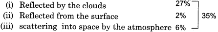
(2) The remaining volume of solar radiation 65%
(B) Earth’s heating budget
![]()
(C) Heat budget of atmosphere:
![]()
RBSE Class 11 Physical Geography Chapter 12 Essay Type Questions
Question 1.
What are the conditions that give rise to inversion of temperature? Explain them.
Answer:
The temperature decreases when we go upwards to various heights from the surface in the troposphere, but due to certain special circumstances, the temperature increases instead of decreasing. Such a condition is called thermal inversion.
Conditions responsible for temperature inversion:
The conditions responsible for thermal inversion have been described as follows:
1. Dry air:
When the vapor absorbs heat emitted from radiation from the earth and stop , heat from escaping. Because of the absence of this quality in the dry air, the earth cools down shortly.
2. Condition of glaciation:
In the polar and glacial regions, there is rapid thermal irregularity evolving from the surface due to continuous negative radiation or cold wave distortion due to which inversion of temperature takes place rapidly.
3. Stable weather:
In case of stable weather, the process of heat radiation takes place uninterrupted. In the absence of change in the weather, the same conditions remain for a long time. Therefore, there is no interference in thermal inversion.
4. Cold and long nights:
Nights are longer in winter. Cold waves are radiated in place of heat waves from the surface of the earth in the last phase of such nights. Due to this, cold waves develop in place of hot waves from the surface of the earth. Due to this, the temperature of the layers which are in contact with such surfaces decrease rapidly, while the temperature of the layers present above it remains higher.
5. Clear sky:
The radiations coming out of the earth at the night time return upon colliding with the clouds, so that the earth does not cool down. This heat does not return to the earth in a clear sky, which causes the earth’s surface to cool quickly and the possibility of thermal inversion increases.
6. Steady air:
The continuous blowing of winds prevent the temperature of a particular place from falling. In winter, the effect of coldness can spread to lower layers, due to the calmness of wind and clearness of the sky, in the long nights, thus causing thermal inversion.
7. Shielded valleys:
In deep valleys with more steep slopes, the cool air is accumulated down with intensity. Due to this, thermal inversion is caused.
8. Entry of cold air zone:
When the cold air zone pushes up a hot air zone, the situation of thermal inversion is created.