Rajasthan Board RBSE Class 11 Physical Geography Chapter 13 Air Pressure Belts and Winds
RBSE Class 11 Physical Geography Chapter 13 Text Book Questions
RBSE Class 11 Physical Geography Chapter 13 Multiple Choice Questions
Question 1.
Who discovered air pressure?
(a) Trivartha
(b) Ferrel
(c) Gurich
(d) Finch
Answer:
(c) Gurich
Question 2.
What is the extent of the equatorial low pressure belt?
(a) 5° north to 5° south latitudes
(b) 30° to 35° Northern and Southern latitudes
(c) 60° to 65° Northern and Southern latitudes
(d) None of these
Answer:
(a) 5° north to 5° south latitudes
Question 3.
Which is the hot and dry wind that runs in the plains of northern India and Pakistan?
(a) Chinook
(b) Loo
(c) Mistral
(d) Bora
Answer:
(b) Loo
Question 4.
Winds that run in the fixed direction throughout the year are called:
(a) Uncertain winds
(b) Seasonal Winds
(c) Permanent winds
(d) Local Winds
Answer:
(c) Permanent winds
Question 5.
The ‘Doldrum’ belt is found:
(a) near the Equator
(c) near the Tropic of Capricorn
(b) near the Tropic of Cancer
(d) near the Arctic Circle
Answer:
(a) near the Equator
RBSE Class 11 Physical Geography Chapter 13 Very Short Answer Type Questions
Question 1.
What is the standard unit of measuring air pressure?
Answer:
The standard unit of measuring air pressure is Millibar.
Question 2.
Where does the Mistral wind blow?
Answer:
Mistral wind mainly blows in the north – western part of the Mediterranean Sea, especially in Spain and France.
Question 3.
Which is the wind that blows in the Alps Hill region?
Answer:
For wind below in the Alps mountainous region, which proceeds from the southern slope of the Alps mountain and descends down to the north along with the slope.
Question 4.
What is the expanse of the equatorial low – pressure belt?
Answer:
The equatorial low-pressure belt is located between 5° north and 5° south latitudes on both sides of the equator.
Question 5.
What is wind?
Answer:
Wind refers to the perceptible natural movement of air. This is the transmission of air on the surface in any direction and at any speed.
RBSE Class 11 Physical Geography Chapter 13 Short Answer Type Questions
Question 1.
What is air pressure?
Answer:
The atmosphere is present around our Earth and it is a thousands of kilometers thick coat made up of many gases. This gaseous cover exerts pressure on the land, which is called air pressure. It is often expressed as atmospheric pressure exerted on any regional unit of the surface. The average air pressure on the ocean surface is 1013.25 millibars. The air pressure decreases upwards above the surface. At an altitude of about 540 meters from the sea level, the amount of air pressure is half of that the sea level.
Question 2.
What is Doldrum?
Answer:
The equatorial belt which extends from the equator to 5° latitude in both the hemispheres. In this belt, due to high temperature throughout the year, air pressure is less. The centrifugal force has the most effect on this belt. The surface horizontal winds do not blow in this belt, but because of high temperature, the air lightens and rises upwards and the convection currents are created. Therefore, this belt is also called belt of calm or Doldrum Belt.
Question 3.
What is meant by prevailing winds?
Answer:
According to the condition of air pressure on the Earth, trade winds, westerly winds and polar winds blow on earth. All these winds blow in a certain direction and a fixed order throughout the year. Such winds blowing in a particular direction and sequence across the entire year are called permanent winds. These permanent winds are also known as prevailing winds, planetary winds, and global winds.
Question 4.
What is meant by ’Loo’?
Answer:
During summers, in the north-western part of India and in Pakistan’s plain areas, very hot and d/y winds usually blow from west direction after noon time. These extremely hot and dry winds’ are called ‘Loo’. These winds often blow in the months of May – June. Due to these winds, the weather becomes very hot and painful. Summertime crops and grasses get dried-up due to the impact of these winds.
Question 5.
Write the names of factors affecting air pressure.
Answer:
The major factors affecting air pressure include temperature, altitude, water vapor and various dynamic factors. Their brief description is as follows:
1. Temperature:
Temperature and air pressure often have an opposite relation. Air pressure is less in regions having higher temperature and air pressure is more in regions of low temperature.
2. Water vapor:
The greater the presence of water vapor, the lower will be the air pressure, while greater air pressure will be found in conditions of dry air.
3. Height:
Air pressure decreases along with increase in height from sea level.
4. Dynamic reason:
The rotation of Earth controls the variation of air pressure on the land.
RBSE Class 11 Physical Geography Chapter 13 Essay Type Question
Question 1.
What is air pressure? Describe the belts of air pressure.
Answer:
The atmosphere which surrounds our Earth is a thousands of kilometers thick coat made of many gases. This gaseous cover exerts pressure on the land, which is called air pressure.
Air pressure belts:
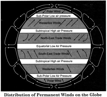
In determining the belts of air pressure found in the world, there is also the role of rotating motion of the earth along with the relation between temperature and pressure. On this basis, there are two types of air pressure belts:
- Thermally Induced Belt.
- Dynamic Induced Belt.
On these two bases following air pressure belts are found in the world:
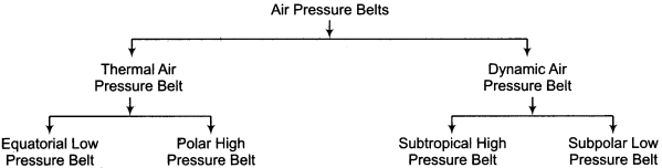
The description of all these belts is given as follows:
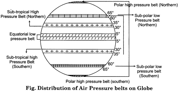
1. Equatorial low pressure belt:
The expanse of this belt extends from 5° north to 5° south latitudes on both sides of the equator. Due to the sun rays falling directly all over the year, the temperature is always high and the air pressure is low. There is excess of water vapor in the atmosphere and the density of the air is low. The speed of rotation on the equator is the highest, due to which, the centrifugal force is the highest here.
Surface horizontal winds do not blow in this belt, but because of high temperature, the air lightens and rises upwards, and the convection currents are born. Therefore, this belt is also called the equatorial ‘belt of calm’ or ‘Doldrum Belt’. This is a Thermally Induced Belt.
2. Sub – tropical High Pressure Belt:
These belts are located between the 30° to 35 0 latitude on both sides of the equator. High temperature, high air pressure and cloudless sky are found throughout the year. One of the main features of this belt is that all the hot deserts of the world are located in this belt on the western edges of the continents.
Due to the absence of friction in the upper part of the atmosphere, these winds in the northern and southern hemispheres turn towards their right and left respectively. These high air pressure regions are also called ‘Horse Latitudes’. This is a Dynamic Induced Belt.
3. Sub – polar Low Pressure Belt:
This belt is located between 60° to 65° north and south latitudes. Low temperature is found in these latitudes. But here, lower air pressure is found instead of high pressure. The reason for this is the rotational speed of the earth. As hot streams flow in this region temperature is found to be more due to which air pressure is less. This is also a Dynamic Induced Belt.
4. Polar high pressure belt:
Due to low temperature near the poles, there is always high pressure. Both of these belts located in the two hemispheres are heat generated. The temperature of the poles and their adjoining areas remains low throughout the year so their surface part always remains glaciated. Therefore, the air near the surface, is very cold and heavy. For this reason, the surface pressure data can not be obtained in sufficient detail from here.
Question 2.
What is meant by wind? How many types of winds are there? Describe.
Answer:
Wind refers to the perceptible natural movement of air. Wind blows from “the high air pressure area to the low air pressure area. It is a natural effort to balance the disparities of air pressure. If the Earth was stable and its surface was flat, then the winds would blow straight from the high – pressure areas to the low – pressure areas, making right angles on the isobars. But in reality, this does not happen, because many factors affect the direction and speed of the wind.
Types of Winds:
Winds have been divided into the following types, depending on their area of influence and duration:
- Permanent Winds
- Periodic Winds
- Local Winds
Many types of winds are included under these three winds, which are shown through the following table:
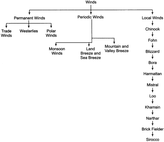
This classification of winds is briefly described as follows:
1. Permanent Winds:
Those winds, which blow in a fixed direction and a fixed order throughout the year, are called permanent winds. They are also known by popular names such prevailing winds, planetary winds, global winds, traditional winds. These winds are related to the belts of air pressure. The major ones are: Trade winds, Westerlies and Polar Winds.
2. Periodic Wind:
The winds which change their direction according to the weather or time are called periodic winds. These include the following types of winds:
- Monsoon winds
- Land Breeze and Sea Breeze
- Mountain Breeze and Valley Breeze
3. Local Winds:
The winds that blow due to the difference in temperature and air pressure of a particular location are called local winds. These winds are in contrast to the prevailing winds blowing there. These winds can be of different types, like hot, cold, ice – filled, dust – rich, in accordance with local characteristics. These have beneficial or harmful effects in the affected areas. The main local winds include Chinook, Fohn, Bora, Sirocco, Harmattan, Khamsin, Mistral, Blizzard, Brick Fielder, Willy – Willy etc.
Question 3.
Perform a scientific analysis of the principles related to the origin of monsoon winds.
Answer:
The word monsoon is derived from the Arabic word ‘Mausim’, which means weather. Therefore, monsoon winds are those winds that change their direction according to the weather. The following concepts are proposed for the origin of these winds:
1. Thermal Concept:
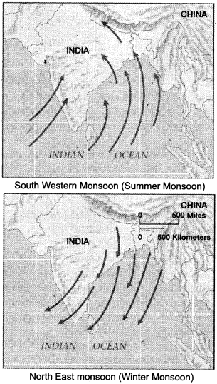
According to this theory, the origin of monsoon is due to the uneven organization of the earth (terrestrial and aquatic part) and due its opposing nature of heating up and cooling down. Due to more insolation in summer, areas of low pressure tend to form in land areas which become more heated up in comparison, due to which the winds move from the sea areas towards the land areas. This is called Summer Monsoon.
On the contrary, in the winter, due to the southward movement of the Sun, terrestrial parts become the centers of high pressure and the sea parts become the centers of low pressure. As a result, the winds blow from the terrestrial part to the oceans, which are called winter monsoons. These are also called the north – eastern monsoon.
2. Motion Concept:
Flon reaffirmed the concept of dynamic origin by refuting the thermal origin of monsoon. According to him, the origin of monsoon winds is due to the air pressure and the shifting of the air belts. Convergence occurs due to the conjunction of trade winds near the equator. This is called tropical convergence zone. Its northern, boundary is called NITC and the southern boundary is called SITC. This ITC has a belt of Doldrum, in between, in which the equatorial ‘Westerlies winds’ blow.
At the time of Summer solstice, the NITC shifts and extends up to 30° North Latitude, which includes South East Asia. Therefore, the doldrum’s equatorial linear westerly winds are established on these parts, which are the southwest monsoon winds of the summer. Similarly, when the motion of the sun is towards the south, NITC shifts from south – east Asia and the north – east trade winds are restored in it. This is the northern – eastern monsoon.
3. Modern Concept:
It is also known as the ‘jet stream’ concept. In southern Asia, this jet stream flows from east to west in rapid form in the troposphere, at an altitude of approximately 12 km. from the west towards the east. It is called sub – tropical westerlies jet stream here. Its altitude is 9 to 10 km. at 60° North latitude and its height is low on the poles.
In the northern hemisphere, this high – level westerly jet stream is split due to the mechanical obstruction of Himalayas and the Tibet Plateau during winter. Its northern branch flows from west to east in the north of Tibetan Plateau (in crescent form) and its main branch flows from west to east in the south of Tibetan Plateau and the Himalayas.
The main branch follows the cyclonic route through the top of Afghanistan and Pakistan. The effect of this is the creation of the autumnal monsoon. In the summer, after March 21, the motion of the sun becomes northwards, due to which polar surface high air pressure becomes weak. Due to the north of the high level polar vortex, towards the north, the high level westerly shift jet stream also shifts towards north.
This jet stream completely disappears from India by mid – June. Now Jet Stream flows in the opposite direction of the winter route north of the Tibetan Plateau. The flow of this high coastal jet stream over the northern part of Iran and Afghanistan is in the form of a cyclonic curve (in the opposite direction of the clock needle), resulting in dynamic downturn and cyclonic condition in the troposphere.
This high level low pressure extends to north – western India and Pakistan. Below this, the thermal low pressure is already developed on the land. Due to this situation, the winds rise above the surface pressure and high level low pressure pulls these winds upwards, due to which sudden burst of south – west monsoon is observed.
RBSE Class 11 Physical Geography Chapter 13 Other Important Questions
RBSE Class 11 Physical Geography Chapter 13 Multiple Choice Questions
Question 1.
Maximum air pressure is found:
(a) Near the earth’s surface
(b) In the stratosphere
(c) In the upper part of the earth
(d) None of these
Answer:
(a) Near the earth’s surface
Question 2.
Where does the rotation velocity of the earth get increased?
(a) On the Tropic of cancer
(b) On the Equator
(c) On the Tropic of Capricorn
(d) On the Poles
Answer:
(b) On the Equator
Question 3.
Which months have been selected mainly for distribution of air pressure?
(a) February and April
(b) March and August
(c) May and September
(d) January and July
Answer:
(d) January and July
Question 4.
In July, the sun is vertical:
(a) on the Equator
(b) on the Tropic of Cancer
(c) on the Tropic of Capricorn
(d) on the Arctic Circle
Answer:
(b) on the Tropic of Cancer
Question 5.
The winds coming from the west are called:
(a) Trade winds
(b) Westerlies
(c) Polar winds
(d) Monsoon winds
Answer:
(b) Westerlies
Question 6.
The area of transmission of the Roaring Forties is:
(a) Between 40° – 50° latitude in the Southern Hemisphere
(b) Near 50° latitude in the Southern Hemisphere
(c) Near 60° latitude in the Southern Hemisphere
(d) Near 50° latitude in the Northern Hemisphere
Answer:
(a) Between 40° – 50° latitude in the Southern Hemisphere
Question 7.
The cold winds in Siberia are called:
(a) Bora
(b) Mistral
(c) Bur an
(d) Jonda
Answer:
(c) Bur an
Matching Type Questions
Question 1.
Match column A with column B in the following:
| Column A (Air Pressure Belt) |
Column B (Latitudinal extent) |
| (i) Equatorial low pressure belt | (a) Between 60° – 65° latitudes in both hemispheres |
| (ii) Sub – tropical high pressure belt | (b) Near the poles in both hemispheres |
| (iii) Sub – polar low pressure belt | (c) Between 30° – 35° latitudes in both hemispheres |
| (iv) Polar high pressure belt | (d) Between 5° North to 5° South latitudes |
Answers:
- (d)
- (c)
- (a)
- (b)
Question 2.
Match column A with column B in the following:
| Column A (Name of the Wind) | Column B (Transmission area) |
| (i) Chinook | (a) On the eastern edge of the Adriatic Sea |
| (ii) Sirocco | (b) On the eastern slope of Rocky Mountains in North America |
| (iii) Harmattan | (c) Sahara Desert towards the Mediterranean |
| (iv) Mistral | (d) Plains of northern India and Pakistan |
| (v) Loo | (e) In the eastern part of the Sahara Desert |
| (vi) Bora | (f) France and Spain |
Answers:
- (b)
- (c)
- (e)
- (f)
- (d)
- (a)
RBSE Class 11 Physical Geography Chapter 13 Very Short Answer Type Questions
Question 1.
Why does air pressure decrease?
Answer:
The pressure in the atmosphere is not uniform everywhere, and all the time, it is controlled by atmospheric conditions. The air expands by getting more heat, which reduces the air pressure.
Question 2.
Which weather phenomena are controlled by air pressure ?
Answer:
Elements of weather; like clouds, rain, storm, dust storm and wind are controlled only by air pressure.
Question 3.
How is rain possible?
Answer:
Through the winds, the oceans provide humidity to the continents, making rainfall possible.
Question 4.
Why is there a difference in air pressure?
Answer:
Due to variations in the controlling factors of the air pressure on the globe, variation in air pressure can be seen on regional basis.
Question 5.
Why there is always low air pressure on the equator?
Answer:
High temperatures remain in the equatorial region throughout the year because most of the time the sun – rays fall vertically. Due to high temperature, air pressure is less.
Question 6.
What is the sub – tropical high pressure belt mainly known for?
Answer:
The sub – tropical high pressure belt is known mainly for all the hot deserts of the world, which are located on the western edges of the continents in this belt.
Question 7.
What does horse latitude mean?
Answer:
On both the sides, between 30° – 35° latitudes of the equator, the sub – tropical high – pressure belt is found. Areas of these high pressure belts are also known as Horse Latitudes.
Question 8.
In the sub – polar belt, the temperature decreases, but the air pressure is low. Why?
Answer:
Low temperature is found in the sub – polar low pressure belt, but in spite of this condition, there is low air pressure in place of high pressure. The main reason for this is the rotating speed of the Earth, because of which the winds rise upwards from here.
Question 9.
What is meant by isobars ?
Answer:
Distribution of air pressure on the map is expressed by the isobars. Lines which are drawn by joining areas having the same air pressure on land and sea, are called isobars.
Question 10.
Why is there a seasonal change in air pressure belts?
Answer:
The pattern of air pressure belts is not found to be the same. There is seasonal change in the air pressure belts due to the movements of the sun towards the south and the north, and due to the difference in nature of land and water, etc.
Question 11.
How do air pressure belts change on seasonal basis?
Answer:
Air pressure belts change according to the position of the sun. In the summer when the Sun is in the northern hemisphere, these belts shift by 5° latitude North and when the sun is in the southern hemisphere these belts shift by 5° latitude South.
Question 12.
Why is the rate of decrease of air pressure not equal?
Answer:
Due to the variation in the density of the air, temperature, the amount of water vapour and the gravitational power of the Earth, the rate of reduction of air pressure is not equal.
Question 13.
Why do humans use oxygen cylinders and special suits while climbing high mountain peaks?
Answer:
At high mountain peaks the air become increasingly sparse and light. As a result, air pressure is greatly reduced. That is why a person uses oxygen cylinders and special suits while climbing high mountain peaks to balance their body’s internal pressure with the outer air pressure land to compensate for lack of oxygen.
Question 14.
Where do the winds move from?
Answer:
Winds move from the area of high air pressure towards the area of low air pressure.
Question 15.
What does Pressure/Barometric gradient mean?
Answer:
Between any two places, the difference between the air pressure is called pressure gradient. Pressure/Barometric gradient is also called barometric slope.
Question 16.
What is the Coriolis effect?
Answer:
Due to the motion of the Earth’s rotation, the winds are deflected. This type of deflecting force is called the Coriolis force and the effect of this force is called the Coriolis effect.
Question 17.
Into how many types have winds been divided on the basis of their area of influence and duration?
Answer:
Winds have been divided into permanent winds, periodic winds and local winds, depending on their influence and duration.
Question 18.
What are trade winds?
Answer:
In both the hemispheres, the winds blowing from the sub – tropical high pressure belts towards the equatorial low pressure belts are called trade winds.
Question 19.
What do you mean by the westerlies winds?
Answer:
In both the hemispheres, the winds blowing towards the sub – polar low pressure belts from sub – tropical high – pressure belts are called westerlies winds.
Question 20.
What is meant by monsoon winds ?
Answer:
The word monsoon is derived from the Arabic word Mausim (season), which means weather. Therefore, the winds that change their direction according to the weather are called monsoon (seasonal) winds.
Question 21.
What are local winds?
Answer:
Winds that blow due to the difference in temperature and air pressure of a particular location are called local winds.
Question 22.
Write the names of some major local winds.
Answer:
The major local winds found in the world are Chinook, Blizzard, Bora, Fohn, Harmattan, Karaburan, Loo, Gibli, Pamparo, Jonda, Brick Fielder, Khamsin, Sirocco, Willy – Willy, etc.
Question 23.
What is Harmattan?
Answer:
The warm and dry winds blowing in the eastern part of the Sahara Desert in Africa, from the north – east and east towards the west, are called Harmattan.
Question 24.
Where do the Bora winds blow?
Answer:
It is a violent dry and cold wind, which blows on the eastern shore of the Adriatic Sea. Especially, the parts of Northern Italy are influenced by these winds.
RBSE Class 11 Physical Geography Chapter 13 Short Answer Type Questions (SA-I)
Question 1.
What is the relation between air pressure and wind circulation?
Answer:
There is a very close relationship between air pressure and wind circulation. The difference in air pressure is the reason for the origin of the winds. The difference in air pressure also affects rainfall and temperature. Wind transfers heat between lower latitudes and higher latitudes, which helps in maintaining the latitudinal heat balance. Through the oceans, the winds provide humidity to the continents, which results in precipitation.
Question 2.
Describe the characteristics of the Equatorial low pressure belt.
Answer:
The following are the characteristics of the Equatorial low pressure belt:
- The expanse of this belt is found in both the sides of the equator between 5° latitudes.
- Due to rays of the sun falling direct in this belt, the temperature is always high and the air pressure is low.
- In this belt, there is excess of water vapor in the atmosphere.
- Horizontal winds do not blow in this belt, but the vertical convectional currents are found here.
- It is also called the belt of calm or Doldrum belt.
Question 3.
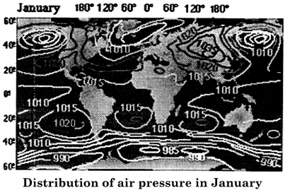
What is the situation of air pressure in January?
Answer:
In January, the sun shines almost vertically on the Tropic of Capricorn in the Southern Hemisphere. Due to this, the temperature in the southern hemisphere is high and air pressure is low. In this period, the area of low air pressure develops in the interior parts of South America, South Africa and Australia, whereas the fully – developed sub – continental high air pressure areas are found in the continents situated in the Northern Hemisphere.
Question 4.
What effect does the earth’s rotation speed have on the winds?
Answer:
Due to the motion of the earth’s rotation, the winds get deflected. This is called the Coriolis force and the effect of this force is called the Coriolis effect. Due to this effect, the wind gets deflected towards its right in the northern hemisphere and towards its left in the southern hemisphere. This effect was proved by a scientist called Ferrel, so it is also called FerreTs law.
Question 5.
How have the trade winds been named? Explain.
Answer:
In ancient times, the sailing ships in the seas facilitated trade through these winds, hence they are called trade winds. These winds are known as the north-eastern trade winds in the northern hemisphere and as the south – eastern trade winds in the southern hemisphere.
Question 6.
Describe the characteristics of trade winds.
Answer:
The trade winds have the following characteristics:
- These winds are dry and calm due to the winds descending down near the sub – tropical high air pressure.
- These winds absorb the water vapor from the water bodies as they proceed ahead.
- Reaching near the equator, these winds are almost saturated with water vapor.
- The trade winds of both the hemispheres collide with each other near the equator and rise up and cause heavy rainfall.
Question 7.
Describe the features of polar winds.
Answer:
Polar winds have the following characteristics:
- These winds move from polar regions towards sub-polar regions.
- In the northern hemisphere, the direction of these winds is from the north – east to the south – west and in the southern hemisphere, it is from south – east to north – west.
- These winds are extremely cold and dry due to blowing from cold polar regions.
- Due to low temperature, their ability to absorb water vapor is also low.
Question 8.
What is meant by North – East Monsoon?
Answer:
In the winter, the position of the Sun is Southwards. Due to this, terrestrial parts become the centers of high pressure and the oceanic parts become the centers of low pressure. Due to this situation, the winds blow from the terrestrial part towards the oceans. These winds are also called winter monsoon or the north – east monsoon.
Question 9.
According to the modern concept, how does the autumnal monsoon arise?
Answer:
An intense wind flow called Jet Stream, runs from west to east in the troposphere, at an approximate height of 12 km. In the northern hemisphere, during winters, this high level jet winds get divided‘due to the mechanical obstruction of Himalayas and the Tibetan Plateau. The main branch follows the cyclonic route through the top of Afghanistan and Pakistan. The effect of this results in the creation of a rainy monsoon.
Question 10.
Explain the features of the Sirocco Winds.
Answer:
The following features and effects of the Sirocco Winds are visible:
- It is hot, dry and sand-filled air which blows towards the Mediterranean Sea in the north from the Sahara Desert.
- This wind is responsible for blood rain.
- When its descends along the northern slope of Atlas Mountains, its aridity and
temperature increases. - These winds are known by different names at different places.
- These winds have disastrous effects on vegetation, agriculture and fruit plantations.
RBSE Class 11 Physical Geography Chapter 13 Short Answer Type Questions (SA-II)
Question 1.
Explain the sub – tropical high pressure belt.
Answer:
The sub – tropical high – pressure belt is found between 30°-35° latitude in both the hemispheres. In this belt, the condition of high temperature, high air pressure and cloudless sky is seen throughout the year. The main feature of this air pressure belt is the presence of all the hot deserts of the world on the western edges of the continents in this belt.
With the absence of friction in the upper part of the atmosphere, these winds turn towards their right and left, in the northern and southern hemisphere respectively. These regions of high pressure are also known as Horse Latitudes. This air pressure belt is considered to be a dynamic belt. In this belt, except for the winter season, the temperature is found to be high. In both the heme spheres, the high pressure centers are found on the oceans in summer. Due to the descending air, the atmosphere remains calm in this belt.
Question 2.
Explain the seasonal changes taking place in the air pressure belts.
Answer:
Distribution of air pressure belts is not equal every where. Daily and yearly changes occur in air pressure, due to factors such as the situation of the summer solstice and winter solstice of the sun, the difference in the nature of the land and the water. In the summer when the Sun is in the northern hemisphere, these belts shift from their average position towards 5° north, and in the winter, when the sun shines directly in the southern hemisphere, these belts shift from their average position to 5° southwards.
Their ideal condition is only on 21 March and 23 September, when the Sun is vertical on the equator. At the time of shift of air pressure belts, the equatorial linear belts get extended in the northern and southern hemisphere between 0° to 10° latitudes instead of 0° to 5° latitudes, according to the season. Similarly, the subtropical belts shift between 30° to 40° latitudes instead of 30° to 35° latitudes, while the sub – polar belt is found between 60° to 70° latitudes instead of 60° to 65° latitudes.
Due to the continental expansion in the polar regions, especially in the North Polar region, it has a greater effect as the polar belt becomes very narrow in summers here. In the southern polar region, due to narrowing of the land and ocean expansion, there is no special change found in them.
Question 3.
Explain vertical distribution of atmospheric pressure.
Answer:
Pascal was the first to explain that air pressure decreases along with altitude in the atmosphere. The density of the lower layers of the atmosphere is high, because the air present above exerts pressure over here. As a result, both the density and pressure of air in the lower layers of the atmosphere is greater. On the contrary, the air of upper layers is less pressurized, so its density and pressure are both low.
That is why the air pressure always decreases along with elevation, but its rate of decline is not always the same. It depends on the density of the air, the amount of water vapor and the gravitational force of the Earth. Because of all these factors being variable, there is no direct proportional relationship between altitude and air pressure.
Even then, the average rate of decreasing air pressure in the troposphere is approximately 34 millibars at an altitude of 300 meters. At higher altitudes, the gases become more sparse and lighter in a rapid form. As a result, air pressure is greatly reduced. That is why a person uses oxygen cylinder and special suit while climbing high mountain peaks.
Question 4.
Explain the features of the sea breezes.
Answer:
During the day time, due to sun light, the terrestrial part of the earth gets hotter than the water, thereby causing the development of low pressure in coastal land parts and high pressure in sea parts. The movement of these winds starts at 10 – 11 a.m. and becomes most active between 1 to 2 p.m. and ends by 8 o’clock in the night.
With the arrival of these winds, in the coastal parts of the tropical regions, the temperature drops to 5 – 7°C within 15 – 20 minutes. As a result, the weather becomes pleasant and healthy. These winds further cause rainfall in the coastal areas. These winds can only blow in the summers during the day time.
Question 5.
Explain the difference between Mountain Breeze and Valley Breeze.
Answer:
The following differences are found between mountain breeze and valley breeze:
| Basis of difference | Mountain Breeze | Valley Breeze |
| Time | Mountain breeze blows during the night time. | Valley breeze blows during the day time. |
| Condition of Pressure | During mountain breeze, high pressure is found on the hillsides and low pressure is found on the valley bottom. | In context to Valley breeze, low pressure is found on lower hills and high pressure is found on valley bottom. |
| Temperature | After sunset, heat loss by radiation is greater on the hill slopes. Due to this, less temperature is found in the upper part and more temperature is found in the valley bottom. | During the day time, the slopes of the hills become warmer than the valley floor due to the sun’s rays. While the rays do not reach the bottom of the valley and less temperature is found there. |
| Naming | These descending winds are also called Katabatic Breeze. | These types of winds move upwards, so they are called Anabatic winds. |
| Period | These winds start blowing after sunset. | These winds start blowing from 9 – 10 a.m. |
Question 6.
Explain the difference between Harmattan and Mistral winds.
Answer:
The following differences are found between Harmattan and Mistral winds:
| Difference | Harmattan Wind | Mistral Wind |
| Transmission area | Harmattan wind blows in the eastern part of the Sahara Desert of Africa from the north – east and the east towards the western direction. | These winds blow in the north – western part of the Mediterranean Sea, especially |
| The nature of the wind | Harmattan is a hot and dry wind. | Mistral is a cold and dry wind. |
| Effect | On the arrival of Harmattan, the weather becomes pleasant and healthy as it reduces humidity. | Along with the arrival of Mistral winds, the temperature in its affected area goes down below freezing point. |
| Handling | Harmattan winds are advantageous. For this reason they are not specially handled. | In order to avoid Mistral winds, garden and bushes are placed at right angle of their flow – direction. |
| Temperature | The temperature of these winds is always found to be more than 0°C. | The temperature of these winds is always found to be less than 0°C. |
RBSE Class 11 Physical Geography Chapter 13 Essay Type Questions
Question 1.
Describe the condition of air pressure of January and July while defining air pressure.
Answer:
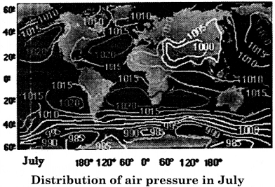
Air pressure on the map is represented by the Isobars. Just like temperature, for determining the air pressure also, two months of the year (January and July) are selected.
The condition of air pressure in January:
In January, the Sun shines almost vertically on the tropic of Capricorn in the Southern Hemisphere. Because of this, there is high temperature and low air pressure. The areas of low air pressure lie in the interior parts of South America, South Africa and Australia. Fully developed sub tropical high air pressure regions are found in the continents of the Northern Hemisphere.
The condition of air pressure in July:
In July, the sun shines almost vertically on the Tropic of Cancer in the northern hemisphere. Due to the land becoming hotter in the northern hemisphere, the area of low air pressure develops there, and in the southern hemisphere, high air pressure belt develops.
Question 2.
Describe the factors affecting the winds.
Answer:
The main factors affecting the condition and direction of the winds are as follows:
- Pressure/Barometric Gradient
- The Motion of the Earth’s Rotation
- The Physical Features.
1. Barometric Gradient:
Between any two places, the difference between air pressure is called ‘Pressure/Barometric Gradient. This gradient is in horizontal direction. Pressure gradient is also called barometric slope. Wind speeds are high when there is more pressure gradient between any two places, but on the contrary, the speed of the wind is slow when the pressure gradient decreases.
2. Earth’s rotational speed (The Motion of the Earth’s Rotation):
Due to the motion of the earth’s rotation, the winds are deflected. This is called the Coriolis force and the effect of this force is called the Coriolis Effect. Due to this effect, the winds are deflected towards their right side in the northern hemisphere and towards their left side in the southern hemisphere. This effect was proved by a scientist called Ferrel, so it is also called Ferrel’s Law.
3. Physical Features:
The terrestrial inequalities on the Earth inhibit the path of the winds, which affects the direction and speed of the winds. The amount of friction on a relatively flat ocean surface is low, causing the wind to flow at a much faster pace. On the contrary, the volume of friction is higher on the plate boundaries, which causes the speed of the winds to slow down.
This is the reason that due to the oceanic expansion in the southern hemisphere, the Westerlies winds flow faster and in a fixed direction. However, due to the terrestrial parts in the Northern Hemisphere, the speed of the Westerlies winds becomes relatively slow.
Question 3.
While defining the types of permanent winds, state their types.
Answer:
Those winds which blow in a certain direction and a certain order through out the year, are called permanent winds. These are also known as prevailing, planetary or global winds.
Types of Permanent Winds:
Permanent Winds are mainly divided into the following types:
1. Trade winds:
Winds blowing in both the hemispheres, from the sub-tropical high air pressure belt, to the equatorial low air pressure belt are known as trade winds. These winds do not blow straight and are deflected to their right side in the northern hemisphere and to their left side in the southern hemisphere as per Ferrel’s Law.
Thus, these winds are called the North Eastern trade winds in the northern hemisphere and the South Eastern trade winds in the southern hemisphere. These winds used to facilitate trading through ships in ancient times, hence they are called ‘trade winds’. These winds have different characteristics in different regions.
These winds are dry and calm as winds descend near the sub tropical high air pressure region. These winds absorb water vapor from the sea surface as they proceed ahead. Reaching near the equator, these winds get almost saturated with water vapor, and become unstable and cause rainfall. The trade winds of the both the hemispheres collide near the equator with each other, and rise up and cause heavy rainfall.
2. Westerlies Winds:
Winds flowing towards sub-polar low air pressure belts from the sub-tropical high air pressure regions in both the hemispheres are called Westerlies winds. Their direction is from the south – west to the north – east in the northern hemisphere. Due to the high intensity of latitude and seasonal changes in the Northern Hemisphere, the western flow of these winds becomes depleted.
These winds are more regular and permanent due to the oceanic expansion in the Southern Hemisphere. Their velocity in the Southern Hemisphere is also high. Due to the intensity of these winds, they are called ‘Roaring Forties’ at 40° – 50° latitudes in the southern hemisphere, ‘Furious Fifties’ near 50° south latitude and ‘Shrieking/Screaming Sixties’ near 60° south latitude. The range of westerlies winds towards the poles is unstable. These winds generate instability in the weather.
3. Polar Winds:
In both the hemispheres, the winds blowing from Polar high air pressure belts to sub – polar low air pressure belts are called polar winds. In the northern hemisphere, their direction is from the north-east to the south – west and in the southern hemisphere it is from south – east to north – west. These winds are extremely cold and dry as they flow from the polar frigid areas.
Due to low temperature, their ability to absorb water vapor is also low. The polar winds that blow rapidly in the northern hemisphere are called ‘Nor’esters’. whose highest impact is felt in North Eastern Canada and the USA.
This pattern of permanent winds found in the world is represented by the following figure:
Question 4.
What is meant by local winds? Describe the world’s major local winds.
Or
On regional basis, the form and nature of the winds is different, how? Explain.
Answer:
Winds that blow due to the difference in temperature and air pressure in a particular location are called local winds. These winds are related to the particular region and the climatic characteristics.
1. World’s main local winds:
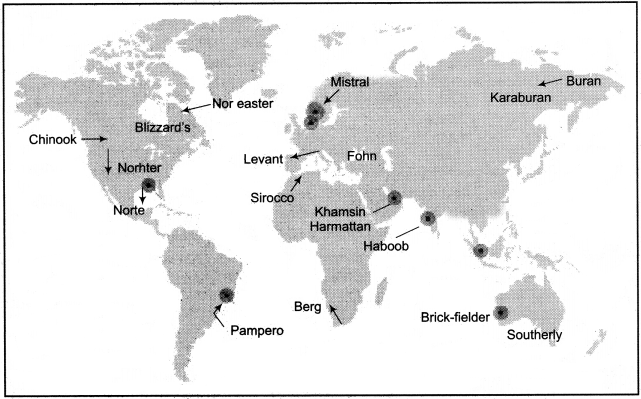
There are many local winds which blow on the regional basis all over the world. The nature of these winds often varies. On the basis of their temperature, cold and hot winds are found; on the basis of moisture dry and moist winds are found, and on the basis of speed, they are found in the form of slow and intense winds. Some of the major local winds found in the world have been described below:
2. Blizzard:
They are also called storm squall. They mainly blow in the United States, Canada and Siberia. Their speed is 80-96 km. per hour. As they contain snow particles, visibility becomes zero. Due to their arrival, the temperature suddenly goes below freezing point and the surface gets covered with snow. In the absence of western – eastern surface obstruction in the United States, these winds reach the southern provinces while affecting all the intermediate plains. Here they are called ‘Nardan’, and in Siberia they are called ‘Buran’.
3. Chinook:
The hot and dry local winds which flow along the mountain slopes are called ‘Chinook’ in North America. The influence of Chinook winds is found especially on the Prairie Plains of the United States. Mainly, these winds blow in the winter season. In this season, snowflakes are spread in the Great Plains of North America. But when these hot and dry Chinooks flow across the Rocky Mountains and descend into the Prairie grasslands of the East, then layers of ice melt quickly. Therefore these winds are also called ‘snow – eating winds’.
4. Fon/Fohn:
These winds descend from the southern slope of Alps mountain and descend to the north along the slope. Due to these winds, the heating of the affected areas increases at a fast pace, i.e. in one or two minutes from 8° to 10° Celsius. With this, the frozen ice melts and the grass grows and the pastures are ready for the animals. As well as agriculture is started. Their most impact is in Switzerland, where these winds blow more during the spring and autumn seasons.
5. Sirocco:
These are hot, dry and “sand – filled winds, which affect Italy, Spain, etc., blowing from the Sahara Desert towards the Mediterranean Sea. The amount of red sand contained in Sirocco winds is high. When it passes over the Mediterranean Sea, it absorbs moisture. Red soil descends along with rain in southern Italy, and this rain is known as’ blood rain’.
Their dryness and temperature increase when they descend on the Atlas mountain’s northern slope. These winds are known by different names at different places. Sirocco in Italy, Simoom in Sahara, Gibli in Libya, Chili in Tunisia, Leves in Spain, etc. . The hot and dry wind that blows in the Arabian Desert is called Simoom. These winds have disastrous effects on vegetation, agriculture and fruit plantations.
6. Harmattan:
The hot and dry winds blowing in the eastern part of the Sahara Desert of Africa, from the north-east and east to the west, are called ‘Harmattan’. Their speed is intense. The western coast of Africa is hot and humid, making the weather unhealthy. On arrival of Harmattan, due to its dryness, the weather becomes pleasant and healthy. Due to this effect, this wind is known as ‘Doctor Air’ on the Guinea Coast. Such hot and dry winds which blow in the Victoria province of Australia, are called ‘Brick fielders’.
7. Mistral:
These are cold, dry and fast moving winds, which affect the north – western part of the Mediterranean Sea, especially Spain and France. Mistral normally runs at an speed of 56 – 64 km per hour, but sometimes, their speed increases up to 128 km. per hour. This causes difficulty in flying the airplanes. In order to avoid these winds, trees and shrubs are planted at right angles to their flow – direction. When these winds arrive, the temperature goes below freezing point.
8. Loo:
It is a hot and dry wind that blows in the plains of north-west India and Pakistan. It blows during the summer season. When this wind blows, it increases the temperature of its transmission area. That is why during the summers, after 9-10 O’clock in the morning, the affected areas become deserted.