Rajasthan Board RBSE Class 11 Physical Geography Chapter 23 Ecosystem of the River Ganga
RBSE Class 11 Physical Geography Chapter 23 Text Book Questions
RBSE Class 11 Physical Geography Chapter 23 Multiple Choice Questions
Question 1.
Which creature has been protected in Vikramshila Aquatic sanctuary?
(a) Gangetic Dolphin
(b) Shark
(c) Alligator
(d) Mahseer fish
Answer:
(a) Gangetic Dolphin
Question 2.
The source of origin of the Ganga is:
(a) Shivpuri
(b) Prayag
(c) Devprayag
(d) Gangotri
Answer:
(d) Gangotri
Question 3.
This animal is found in the Sunderbans:
(a) Lion
(b) Camel
(c) Royal Bengal Tiger
(d) Unicorn
Answer:
(c) Royal Bengal Tiger
Question 4.
Bhagirathi and Alaknanda are:
(a) rivers flowing in Uttar Pradesh
(b) branches of Ganga in Bihar
(c) streams originates from the glaciers of Uttarakhand
(d) Brahmaputra river branches flowing in Assam
Answer:
(c) streams originates from the glaciers of Uttarakhand
Question 5.
Tihri dam is built on which river?
(a) Yamuna
(b) Alaknanda
(c) Mandakini
(d) Bhagirathi
Answer:
(d) Bhagirathi
RBSE Class 11 Physical Geography Chapter 23 Very Short Answer Type Questions
Question 1.
Describe the total length of river Ganga.
Answer:
The total length of river Ganga is 2071 kms.
Question 2.
Where does the river Ganga enter into the plains?
Answer:
The river Ganga enters plain into the first in Haridwar.
Question 3.
Name the most polluted area of Ganga river.
Answer:
The area from Bithoor to Kanpur is the most polluted area of Ganga river.
Question 4.
Name the components of ecosystem.
Answer:
Components of ecosystem include biotic and abiotic components. In each ecosystem, the nature, structure, functioning, degradation and depletion of ecosystems is involved.
Question 5.
Where is Farakka Barrage located?
Answer:
Farakka Barrage is built on the Indo – Bangladesh border, which is 2240 meters in length.
RBSE Class 11 Physical Geography Chapter 23 Short Answer Type Questions
Question 1.
Explain the importance of ecosystem.
Answer:
Ecosystem is a landmark of a specific biotic and abiotic identity. Ecosystems present the major conditions of life on the earth. The biotic and abiotic components of each ecosystem have a deep mutual inter – relationship. Fresh or soft water is obtained from aquatic ecosystem. All the world’s civilizations have originated in the areas of aquatic ecosystem. Through aquatic ecosystem, human beings receive biotic and abiotic resources.
Question 2.
Name the fresh water ecosystems.
Answer:
The ecosystem of rivers is included in the ecosystem of fresh water. The ecosystem of rivers is kept in the category of fresh or soft and flowing water.
Question 3.
In which area is the purest water found in the river Ganges?
Answer:
In the mountainous areas, water of river Ganga is the purest.
Question 4.
What is’Sunderban’?
Answer:
From Kishanganj, the Ganges and its tributaries are divided into the plains of the entire West Bengal, from which a Delta region is formed. These forests are found in the seaward swampy area are called the Sunderbans. It is a protected area in both India and Bangladesh. This is one of the leading areas of the world in terms of bio – diversity. Here, mangrove and tidal type of vegetation is found. The forests have been named after the large number of ‘Sundari tree’ species found here.
Question 5.
What does the term extended delta mean?
Answer:
The rivers deposit the sediments brought with them in their area of flow or before merging into the ocean. Generally, the triangular shape created by this process is called Delta. When the location of the delta is seaward and the rivers continue to deposit sediments brought along with them in this delta area, then the size of the delta continues to grow in the sea water due to continuous rise of sea level and deposition of debris. Thus the Delta area, which is constantly changing in size, is called the extended delta.
RBSE Class 11 Physical Geography Chapter 23 Essay Type Questions
Question 1.
Describe the ecosystem of the Central Ganga Valley region while explaining the river ecosystem.
Answer:
The ecosystem of rivers is kept in the category oc fresh or soft and flowing water. All civilizations in the world have originated in the fresh water river valleys. These are considered to be the cradle of human civilization. Therefore, rivers of fresh water in all civilizations have been recognized as mothers.
Central Ganga Area:
Central Ganga Plain covers the areas of Eastern Uttar Pradesh and Bihar State. These are populated areas of human settlement. The main occupations of the residents are agriculture, animal husbandry, fishery and cottage industries based on them. In this area there are major tributaries of Ghaghra, Gandak, Kosi and Son, etc. Here, the flow of the Ganga diminishes and pollution is greatly increased by the mixing of mud, garbage, stool – urine, chemicals, etc. In these areas, the formation of the meander, alluvial soil plains, ox-bow lake, etc. also takes place.
Due to high pollution, the river’s water is also not suitable for bathing or drinking. Due to floods in the Kosi river in this area, there is a loss of excessive public life and property in Bihar. Fresh water dolphins, turtles, crocodiles, alligators, fish, etc. are the main creatures found in the rivers of this area. Vikramshila Dolphin Sanctuary in Bihar has been set up in 50 km area in Bhagalpur district. In this region, dolphin (souns) has been declared a national aquatic creature. It is also called the Tiger of fresh waters Dense forests are also found in this area. They are rich in wildlife.
Question 2.
Explain the pollution of river Ganga and perform a review of its causes and prevention.
Answer:
Ganga river is the national and a huge river of India. At present, the degree of pollution in the river is constantly increasing, by which river water is becoming harmful! for human use. This polluted water is destroying the river ecosystem rapidly. The amount of toxic material dissolved in the water of the river was measured 6.8 -7.2 MG / L. This amount is very high. In general, this quantity should be 4.0 MG /L.
Haridwar, Kanpur, Allahabad, Varanasi and Patna recorded the highest level of Ganga water pollution. Similarly, the presence of dissolved bio – organisms (BOD) was found to be very high from Kannauj to Varanasi. In Kanpur it was recorded to be around 16.39 mg / litre. This was recorded to be the lowest 3 mg / liter in the mountainous regions. Similarly, 15.58 MG / littre B.O.D was recorded in delta regions beyond Patna. The quantity of D.O and B.O.D. was found to be different before and after the monsoon.
Similarly, in Kannauj, Kanpur, Allahabad and Varanasi the presence of coliform was found to be the highest in river water. Due to the high D.O. And B.O.D. and coliform, the amount of / pollution was found to be more in river water.
Causes of pollution of Ganga river:
Ganga river is being polluted due to many pollutants being mixed in this huge river. The causes of pollution of this river are:
- Settlement of 2500 – 3000 cities is found on both sides of this river. Because of this, river water gets polluted due to massive human density.
- As the human urine and waste is directly introduced into the river through sewer lines, the river is polluted.
- Its pollution is increasing due to improper disposal of various types of wastes.
- The work of agriculture and animal husbandry is done on both sides of this river. Water is polluted by this process also.
- The river’s water is polluted due to the waste from the industries which are found in the cities situated on the banks of this river.
- The process of cremation of dead bodies on the river banks is also polluting it.
- Pollution in the river has increased very rapidly due to the dumping of wastes from chemical, leather, fertilizer and other industries and sewage and wastes from the cities, in the Ganges river. This water cannot be used for bathing or drinking.
Prevention of Pollution of Ganga River:
- Ganga Action Plan is implemented smoothly and at a rapid pace.
- Increasing political and administrative will power and foresightedness.
- Corruption should be completely eliminated.
- Planting of trees should be promoted.
- There should be a proper arrangement for disposal of waste water, industrial wastes and solids.
- The sewage water should be introduced into the river after due process in sewage treatment plants.
- The process of dead bodies immersion should be stopped.
- There should be a proper arrangement for disposal of chemical substances and various chemicals emitted from industries.
- All people should take care not to pollute the Ganga, considering this to be their moral responsibility.
Question 3.
Explain the term bio – diversity, and describe the bio-diversity of the Sunderbans.
Answer:
The number of species of living organisms and plants available in a natural region is called bio – diversity.
The situation of Sunderbans:
In the eastern part of India, a delta region has been formed by the Ganges river. The Ganges as well as its tributaries have extended their contribution in its. Due to the very mild slope of the Ganges and its tributaries, a deposition of alluvial soil is seen merges before the river enters into, the ocean. The expanse of this delta part is approximately 60000 square km. There are many forests found in this seaward swampy area, which have an abundance of a tree named Sundari. On this basis, this Delta region has been named as Sunderbans.
Bio – diversity in the Sunderbans:
Due to swampy and humid conditions in the Sunderbans Delta part, various types of fauna and plant species are found. This is one of the leading areas of the world in terms of bio-diversity. Here, mangrove and tidal vegetation is found. Here the flora and fauna can survive in the mixture of fresh and salt water. The world-famous Royal Bengal Tiger is found in this area. Apart from these, many types of carnivorous and herbivorous creatures are also found in the Sunderbans.
RBSE Class 11 Physical Geography Chapter 23 Other Important Questions
RBSE Class 11 Physical Geography Chapter 23 Multiple Choice Questions
Question 1.
What is the drainage area of the Ganga river in India?
(a) 9.51 lakh square km
(b) 8.61 lakh square km
(c) 7.51 lakh square km
(d) 6.61 lakh square km
Answer:
(b) 8.61 lakh square km
Question 2.
What is the cradle of human civilization?
(a) Mountains
(b) Plateaus
(c) River valleys
(d) Beaches
Answer:
(c) River valleys
Question 3.
Which is considered the national sacred river of India?
(a) Ganga
(b) Yamuna
(c) Brahmaputra
(d) Cauvery
Answer:
(a) Ganga
Question 4.
The river Ganga starts from the rivers?
(a) Sutlej and Beas
(b) Bhagirathi and Alaknanda
(c) Son and Ghaghra
(d) Jhelum and Chenab
Answer:
(b) Bhagirathi and Alaknanda
Question 5.
Which of these has been declared the National Aquatic animal of India?
(a) Turtle
(b) Dolphin
(c) Alligator
(d) Shark
Answer:
(b) Dolphin
Question 6.
The confluence of rivers Ganga, Yamuna and Saraswati takes place in:
(a) Rishikesh
(b) Allahabad
(c) Nashik
(d) Patna
Answer:
(b) Allahabad
Question 7.
Which species of trees are mainly found in mangrove forests in India?
(a) Cedar (pine)
(b) Cinchona
(c) Sundari
(d) Gutta – percha
Answer:
(c) Sundari
Matching Type Questions
Match column A with column B:
Question A.
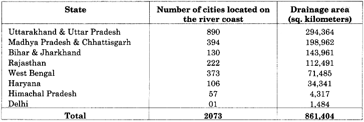
| Column A (State’s name) | Column B (Ganges river water flow area in |
| (i) Delhi | (a) 143,961 |
| (ii) Himachal Pradesh | (b) 71,485 |
| (iii) West Bengal | (c) 1,484 |
| (iv) Uttarakhand & Uttar Pradesh | (d) 4,317 |
| (v) Bihar & Jharkhand | (e) 294,364 |
Answers:
- (c)
- (d)
- (b)
- (e)
- (a)
Question B.
| Column A (Names of regions) | Column B (Ecosystem of the Ganges) |
| (i) Devprayag | (a) plains |
| (ii) Khadar and Bangar area | (b) lower Ganges plains |
| (iii) Kishangani | (c) middle Ganges plains |
| (iv) Bhagalnur | (d) hilly areas |
Answers:
- (d)
- (a)
- (b)
- (c)
RBSE Class 11 Physical Geography Chapter 23 Very Short Answer Type Questions
Question 1.
What is ecosystem?
Answer:
Ecosystem is a landmark of a particular Biotic and Abiotic identity. This system presents major conditions of life on the earth.
Question 2.
Which has been included in terrestrial ecosystem?
Answer:
In terrestrial ecosystem, forests, pastures, deserts, mountains and islands are included.
Question 3.
Which has been included in aquatic ecosystem?
Answer:
In aquatic ecosystem, ponds, lakes, swamps, rivers, delta and oceans are included.
Question 4.
The plain of northern India is built by which rivers?
Answer:
The plain of northern India is built by rivers Indus, Saraswati, Yamuna, Ganga, Brahmaputra and their tributaries.
Question 5.
Into how many parts is the ecosystem of river Ganges divided?
Answer:
The ecosystem of river Ganges is divided into four parts – mountainous ecosystem, plain region ecosystem, middle Ganges plains and lower Ganges plain ecosystem.
Question 6.
Which place is called Ramsar?
Answer:
Many riverine wetlands can be seen in India. In the plains of the Ganga, there is a rich bio-diversity in the vicinity of Shivpuri. This place has been called Ramsar.
Question 7.
Why does the Ganga get more polluted in Kanpur?
Answer:
The leather industry has grown in Kanpur. Due to this industry, Ganga gets more polluted in Kanpur.
Question 8.
What does Khadar mean?
Answer:
Khadar is a riverine area that faces floods every year because of its lower elevation as compared to its adjoining area. Due to this there is a deposit of new alluvial soil every year.
Question 9.
What does Bangar mean?
Answer:
Bangar is such a riverine area which does not experience flooding every year due to its high elevation. Older Alluvium deposits are found in this area.
Question 10.
What is Doab?
Answer:
The land area spread between two flowing rivers is called Doab.
Question 11.
Where is the central plains of the Ganga extended?
Answer:
The expanse of the central Gangetic plains is in Eastern Uttar Pradesh and Bihar states.
Question 12.
What is called the Tiger of fresh water?
Answer:
In 2010, dolphin was declared as the National Aquatic animal of India, and it is known as tiger of fresh water.
Question 13.
Where and when is the Mahakumbh festival held?
Answer:
In Prayag (Allahabad), the Mahakumbh festival is organised every 12 years at the confluent of Ganga, Yamuna and Saraswati rivers.
Question 14.
Where is the lower Ganga plain spread?
Answer:
The lower Ganga plain is spread across Kishanganj (Purnea-Bihar) up till entire West Bengal (excluding upper hilly areas) and Bangladesh.
Question 15.
What is the main feature of the Sunderban region?
Answer:
The main feature of this ecosystem is that here vegetation and organisms can survive in a mixture of fresh and salt water. This delta region is expanding towards the ocean continuosly.
Question 16.
Where is greatest amount of Coliform found in the water of river Ganges?
Answer:
Greatest amount of coliform in the Ganga waters is found at Kannauj, Kanpur, Allahabad and Varanasi.
Question 17.
Why have the positive effects of the Ganga Action Plan not come yet?
Answer:
Due to lack of political and administrative will power and foresightedness in India and the situation of corruption prevailing in the country, the positive effects of Ganga Action Plan are not visible yet.
Question 18.
What will be the benefit of conservation of river Ganges?
Answer:
The conservation of the Ganges river will not only help to ensure the purity of water of the river but it will also ensure smooth functioning of human, flora, fauna, environment and greater ecosystem.
Question 19.
What problems have emerged due to Deforestation?
Answer:
Due to the process of deforestation, soil erosion, landslide, flood, scanty rainfall and desertification process have been encouraged.
Question 20.
How can we preserve the Ganga?
Answer:
When we do not consider the Ganga river as the responsibility of the government and take its responsibility on ourselves and the society, and we begin to believe the Ganga to be our sacred mother in practice, only then it can be preserved in the real sense.
RBSE Class 11 Physical Geography Chapter 23 Short Answer Type Questions (SA-I)
Question 1.
What is the meaning of ecosystem? Explain its form.
Answer:
The ecosystem is a specific biotic and abiotic identity landscape. Ecosystem can be terrestrial and aquatic. Through these ecosystems, the key conditions of life on earth are visible. The biotic and abiotic components of each ecosystem have a deep mutual inter – relationship. In the terrestrial ecosystems, forest, grassland, desert, mountain, island, etc., and in aquatic ecosystems, ponds, lakes, swamps, rivers, delta and oceans are included. Some basic elements are present in each ecosystem. For example, natural structure of ecosystem, its system of functioning, use, degradation of ecosystem and rejuvenation and protection are given prominence.
Question 2.
Explain the Drainage area of the Ganges river and its tributaries with the help of a table.
Answer:
State – wise distribution of drainage area of Ganga river and its tributaries is given as follows:
Question 3.
Explain the nature of Mahakumbh Festival.
Answer:
At the confluence of Ganga, Yamuna and Saraswati rivers in Prayag (Allahabad), Mahakumbh festival is organised after every 12 years, in which millions of tourists from India and abroad come. It is the biggest encampment of the human community on the earth, filled with devotion and faith. This has spiritual and religious significance.
According to legends, nectar drops had fallen during ‘Sagar Manthan’ at this place. This fair is organised in special astronomical conditions. “Poorna Kumbh”takes place in 144 years. According to belief, bathing at this Mahakumbh fair gives freedom from all the sins. In 2013-14, Harvard University of the United States had included Mahakumbh fair for its study and research in its courses. The arrangements of this fair have been praised to be extremely well-organised. The next Mahakumbh Will be held in 2025.
RBSE Class 11 Physical Geography Chapter 23 Short Answer Type Questions (SA-II)
Question 1.
Describe the mountainous region of the Ganges River ecosystem.
Answer:
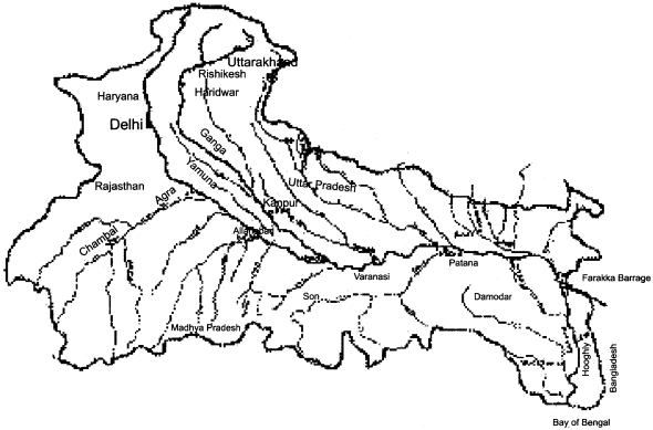
The mountainous ecosystem of river Ganges is mainly found in the North Indian state of Uttarakhand. This region is spread in Uttar Pradesh also. Ganga is the national and most sacred river of India. The river Ganga originates in the form of Bhagirathi and Alaknanda. The average height of this river’s origin is 3140 meters above sea level.
The main branch of river Ganga is Bhagirathi, which originates from the Gangotri glacier from the place called Gomukh of Garhwal Himalayas. It originates from the mouth of a small cave. The river’s water source is a basin located at 5000 meters height. There is an important contribution many small tributaries in taking shape of river Ganges.
The confluence of several water bodies at Dev Prayag gives form to Ganga River. Ganga river enters the plain of Haridwar for the first time, after travelling a narrow hill path of about 200 kms.- Before this, the river produces deep valleys, while making several turns. On both sides, large rocks, boulders, pebbles and sand are deposited in heavy quantities. The slopes on both sides are very steep.
Question 2.
Describe the dams and barrages built on river Ganga.
Answer:
Many dams and barrages built on the river Ganges are an important part of Indian life and economy. The most prominent of these are the Farakka Barrage (2240 meters long, inaugurated on 21 April 1975) on the Indo – Bangladesh border. This was made to provide irrigation, fishery, water in Hooghly (in summer season) and to protect the port of Kolkata port from silt.
Similarly, ‘Tihri Dam’ on Bhagirathi river has been built for supply water to multipurpose projects. Its height is 261 meters. This provides generation of hydro-electricity 2040 MW power and irrigation to 270000 hectare area and a daily supply of 102.20 crore litres of drinking water to Delhi, Uttar Pradesh and Uttarakhand. The third largest dam is the ‘Bhimgoda Dam’ located in Haridwar, which was built by the British in 1940.
Water of this dam is used for irrigation, fisheries, provision of drinking water. Apart from these, many barrages have been built near the Nepal border on the Sharda, Kosi and Gandak rivers. These are used for power generation, irrigation and drinking water purposes. These dams have many advantages but there is a huge problem of silt deposition in this area, due to which ‘Farakka Barrage’ is the most affected.
RBSE Class 11 Physical Geography Chapter 23 Essay Type Questions
Question 1.
Explain the ecosystem of river Ganges.
Or
The ecosystem of river Ganga is divided into different parts, how? Clarify.
Answer:
The Ganges River is a river of India with a vast drainage area. The entire ecosystem of this river is divided mainly into the following parts – 1.mountainous region, 2. plain areas, 3. central Ganga plain, 4. lower Ganga plain.
Mountainous region:
Ganga is considered to be the national and most sacred river of India. Over the centuries, the Aryans residents of India have been residing here. Ganga river has nurtured the incarnations of Rama, Krishna, Gautam, Mahavir, Nanak, etc. in its vicinity. Therefore, this holy river paves the way to heaven.
The river Ganga starts in the form of Bhagirathi and Alaknanda. The average height of this river’s origin is 3140 meters above sea level. The main branch of river Ganga is Bhagirathi, which originates from the Gangotri glacier from a place called Gomukh of Garhwal Himalaya. It originates from the mouth of a small cave.
The river’s water source is a basin located at a height of 5000 meters. Many small tributaries have extended significant contribution in giving shape to river Ganga. The confluence of several water bodies in Dev Prayag has given form to the Ganga River. Ganga river enters the plain of Haridwar for the first time, after travelling a narrow hill path of about 200 kms.
Before this the river produces deep valleys, while taking many turns.More than 600 metre-deep valleys are found in many places.On both sides, large rocks, boulders, pebbles and sand are deposited in heavy quantities. The slopes on both sides are very steep.
Plain areas:
Bio – diversity and cultural – spiritual aspects of this area are very important. Fisheries of ‘MaKaseer’ species are found in this area and the area around Shivpuri has rich bio-diversity. The sand mounds, flood plains and ox-bow lakes are built in the Garhmukteshwar area. In these areas, dolphins, alligators and turtles are found. This is called ‘Ramsar’.
On reaching Farrukhabad, debris increases in the Ganga river. The nature of flood plains becomes very wide. In these areas, agricultural, fishery, animal husbandry and number of human population and habitat increases. On the river banks, religious rituals like bathing and cremation are done. This leads to increased pollution in the river. The number of birds of various species, insect mites, creeping organisms are found to be more.
Central Ganga plain:
Central Ganga plain covers the areas of Eastern Uttar Pradesh and Bihar State. These are populated areas of human settlement. The main occupations of the residents are agriculture, animal husbandry, fishery and cottage industries based on them. In this area, there are major tributaries of Ghaghra, Gandak, Kosi and Son, etc.
Here, the speed of the Ganga lessens and pollution is greatly increased by the mixing of sand, mud, garbage, stool – urine, chemicals, etc. In these areas, the land formation of the meander, alluvial soil plains, ox – bow, etc. also takes place. Due to high pollution, the river’s water becomes unsuitable for bathing and drinking. During floods, there is a loss of excessive public life and property in Bihar.
Dolphins, turtles, crocodiles, alligators, fish, etc. are the main creatures found in the rivers in this area. Vikram Shila Dolphin Sanctuary in Bihar has been set up in 50 km. area in Bhagalpur district. In this order, dolphin has been declared a national aquatic creature of India. It is called the tiger of fresh water. Dense forests are also found in this area. They are full of wildlife.
Lower Ganges plains:
This part of Ganga is spread from Kishanganj (Purnea – Bihar) to entire West Bengal (excluding high mountainous areas) and within Bangladesh. In this area, the river Ganga and its tributaries get divided into innumerable small streams. Delta region offers an incomparable view due to the presence of very mild slopes and Alluvial soil.
The total area of this Delta part is 60000 square km, whose forests are known as Sunderbans. This is a protected area in both India and Bangladesh.lt is one of the leading areas of the world in terms of bio – diversity. Here, mangrove and tidal vegetation is found. Due to the large number of ‘Sundari Tree’ species found here, this forest has been named ‘Sunderbans’.
The main feature of the ecosystem here is that the flora and fauna can survive in the mixture of fresh and saline water. This world’s largest Delta is continuously expanding towards the ocean. World famous Royal Bengal tigers are found in these forests. Apart from this, all types of carnivorous and herbivorous animal, birds, etc. are found in the Sunderbans.