Rajasthan Board RBSE Class 11 Physical Geography Chapter 5 Origin of Continents and Oceans
RBSE Class 11 Physical Geography Chapter 5 Text Book Questions
RBSE Class 11 Physical Geography Chapter 5 Multiple Choice Questions
Question 1.
The ocean circling around Pangaea was:
(a) Atlantic
(b) Panthalassa
(c) Tethys
(d) Arctic
Answer:
(b) Panthalassa
Question 2.
According to Wegener, the direction of the displacement of the continents, are:
(a) South and North
(b) East and Equatorial
(c) North and West
(d) West and Equatorial
Answer:
(c) North and West
Question 3.
The only thing related to plate tectonics is:
(a) Communion
(b) Pangaea
(c) Tethys
(d) Arctic
Answer:
(d) Arctic
Question 4.
Pangaea is composed of:
(a) Sial
(b) Sima
(c) Nife
(d) Sial and Sima
Answer:
(a) Sial
Question 5.
‘Plate’ word was first used by:
(a) Finches
(b) Tuzo Wilson
(c) Wegener
(d) Griffith Taylor
Answer:
(b) Tuzo Wilson
RBSE Class 11 Physical Geography Chapter 5 Very Short Answer Type Questions
Question 1.
What is Pangaea?
Answer:
According to Wegener, in the Carboniferous Era, a super continent that incorporated almost all the landmasses on earth is called Pangaea.
Question 2.
Mention the types of plate margins.
Answer:
There are three types of plate margins:
1. Constructive Plate Margins:
The space formed by the displacement of the two plates form a new one. It is called the constructive Plate margins.
2. Destructive Plate Margins:
The convergence of the plates leads to the dispersal/erosion of plates. This is called the Destructive Plate margins.
3. Protective Plate Margins:
When the plates create neither the erosion nor the formation of new substances, this is called the Protective Plate margins.
Question 3.
Which rocks are there in the proximity of the Atlantic coast?
Answer:
The mid – Atlantic ridge is in the vicinity of the Atlantic coast.
Question 4.
What do you mean by Panthalassa?
Answer:
According to Wegener, in the Carboniferous Era, there existed one big landmass which he called Pangaea which was surrounded by one big ocean called Panthalassa.
Question 5.
What is the average thickness of the plate?
Answer:
The average thickness of the plate is considered to be 100 km.
RBSE Class 11 Physical Geography Chapter 5 Short Answer Type Questions
Question 1.
Write the geographic proof of the Continental Drift theory.
Answer:
The following geographic proofs are found about the Continental Drift Theory, enumerated by Wegener:
1. Equilibrium setting in the Atlantic shores:
The amazing similarity exists in the east and the west coasts of the Atlantic Ocean. These two shores if joined together will fit in perfectly (like a jigsaw puzzle). According to Wegner, the rise of West Africa can be traced back to the Gulf of Guinea and the north – eastern part of South America.
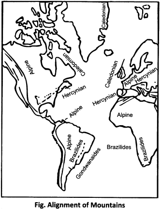
2. Alignment of the mountains:
If the displaced continents are kept together, then there is considerable similarity in the alignment of the ranges of all ages. This alignment is found in the ranges of Caledonian, Hercynian, Alpine eras.
3. Origin of new folded mountains:
Wegener imagined the existence of the demons on the place of Rockies, Andes, the Alps and the Himalayas. In which the pressure on the sediment seduced is due to the origin of the mountains.
Question 2.
What does JIG – SAW – FIT mean?
Answer:
According to the Continental Drift Theory proposed by Wegener, various continents were considered to be one single landmass in the ancient time. These all are separated from each other. If these continents are brought back to each other, they can reconnect with each other again. The continents would be able to fit each other in the same way as Wegener called JIG – SAW – FIT.
For example:
both shores of the Atlantic Ocean can be reunited.
Question 3.
What is the action of making island arc on the margins?
Answer:
When two plates of similar nature converge, one plate climbs on another while the depletion of a plate occurs. After this the plate’s front is melted when it breaks into an elongated string. This is called the destructive margins. This molten substance reaches out of weak crust and creates volcanic and island arc. Mountains have been formed as island arc on the margins of ocean plates in the Pacific Ocean.
Question 4.
Describe the major plates of the earth.
Answer:
In the theory of plate tectonics, the earth is divided into six main plates, which are as follows:
1. Indian Plate:
This plate comprises of the Indian subcontinent and the terrestrial crust of Australia, the Indian Ocean and the south – western part of the Pacific Ocean.
2. Eurasian Plate:
This plate extends from the Alps to Himalaya ranges.
3. African Plate:
It extends to Antarctica in the south, to the middle Atlantic ridge in the west and Eurasian plate in the north.
4. American Plate:
It is extended as the continent of northern and southern America.
5. Pacific Plate:
This is derived from Eastern Pacific ridges towards the West as the entire Pacific Ocean.
6. Antarctica Plate:
It is extensively extended to oceanic brackets around the Antarctica continent.
Question 5.
According to Wegener, what forces are responsible for the drift of continents?
Answer:
According to Wegener, the following two forces are responsible for the flow of continents:
1. Gravity or flotation force:
This force causes the drifting of land towards the 1 equator. As: the flow of India and Australia.
2. Tidal force:
Due to this force, the drift of land turns towards the west like the flow of North – South America. This flow is due to the combined tidal forces of the Sun and the Moon. In it, the landmass is believed to be drawn by the sun and the moon towards the west.
RBSE Class 11 Physical Geography Chapter 5 Essay Type Questions
Question 1.
Give a critical description of Wegener’s Continental Drift Theory.
Answer:
The continental drift theory was rendered in 1912 by the German climatologist Alfred Wegener. He considered two alternatives to be the chief for the purpose of rendering his theory. First, if the climatic condition is variable, then the terrestrial is stable. Second, the terrestrial part is variable if the climatic condition is stable.
Based on the second option, he had set the theory of the displacement of the continents. According to Wegener, there existed one big landmass which he called Pangaea which was covered by one big ocean called Panthalassa. In the Carboniferous Era, a sea called Tethys divided the Pangaea into two huge landmasses: Angaraland (Laurasia) to the north and Gondwanaland to the south of Tethys.
In the long run, due to their fragmentation, the divided parts flowed .towards the equator and the west. According to Weneger, the continents flowed towards the equator and the west due to gravity or flotation force and tidal force respectively.
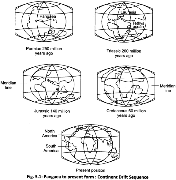
Construction of the continents:
After partition of Angaraland and Gondwanaland, they were redistributed. Angaraland split into Europe, Asia and North America. Gondwanaland split into south America, Africa, Australia and Antarctica continents. The creation of oceans the oceans have been formed by the movement of the continents.
With the separation of the North and South America, the Atlantic Ocean was formed. Being separated from Australia and Antarctica, the Indian Ocean was formed. The remaining part of the Panthalassa was called the Pacific Ocean. This split format of Pangaea and the creation of continental oceans are shown through the following pictures:
Criticisms of Continental Drift Theory:
It has been criticized on the basis of the geographical, biological, geological, geodesical and climatic evidences. All these shortcomings have been displayed as the following points.
- Setting up of equilibrium in the Atlantic shores is defective because the Brazilian coast and Gulf of Guinea could not be fitted completely.
- Middle Atlantic ridge prevents both shore from coming together. Its explanation was not given by Wegener.
- Wegener considered Sial floating on the border while on the other side he told that due to the increased pressure due to displacement in the accumulated sediment, the mountains of Vallat were formed.
- According to geologists, there are only partial similarities in the structural and surface configuration on the Atlantic coast. They cannot be considered as complete evidence.
- The evidence of contemporary fossils is also partial.
- It is not possible that due to the gravitational force, as described by Wegener, the continents can drift.
- Various areas of paleoclimatological do not get complete identification.
Question 2.
Explain the evidence of plate tectonics describing global plates.
Answer:
Scholars do not have a single opinion about the number of global plates, yet most have divided the entire earth surface into 6 large and 20 minor plates. The description of the major plates is as follows:
1. Indian Plate:
This plate comprises of the Indian subcontinent and the terrestrial crust of Australia, the Indian Ocean and the south western part of the Pacific.
2. Eurasian Plate:
This is the only plate that is formed mostly from the continental crust. This plate extends from the mid – Atlantic ridges in the west, the Alps – Himalayan mountain range in the south and to the insular arc in the east.
3. African Plate:
This is a mixed continental and oceanic plate. It extends to Antarctica in the south, to the Middle Atlantic ridge in the west and Eurasian Plate in the north.
4. American Plate:
This includes the continental crust of the North and South America and the Oceanic crust extending from the east to the middle Atlantic Ridge. This plate extends to the west coast of continents and meets the Pacific Ocean plate. This plate is moving towards the west as a unit. As a result there are no tectonic motions on the eastern edges of the American continents.
5. Pacific Plate:
From East Pacific Ridge to the West, it is the only plate extending across the Pacific Ocean that is fully formed from oceanic crust.
6. Antarctica Plate:
Most of the Antarctica Plate is glaciated. This plate extends across the Atlantic continent to mid-ocean brackets.
Proof of plate tectonics:
Evidences of plate tectonics include seamless variance, continental drift, widening of rift valleys, seismic incidents, volcanic activity, mountain formation process, island arcs.
Some of these are briefly described as follows:
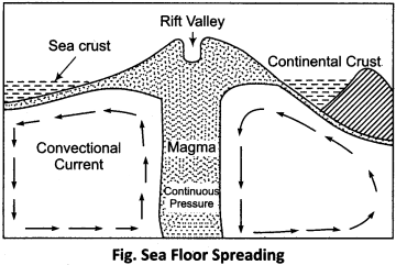
1. Sea floor spreading:
Flat spaces are formed in the opposite direction of two plates on the divergent edges. Magma rises above the convection function in these empty spaces, and the lava gets deposited above, which creates new styles. The continuation of this process keeps the order of forming the new shell crust. As a result, the ocean bottom is expanding.
2. Continental Drift:
New discoveries related to continental drift – Pervasive and sea – level movements have strengthened the fact that the continents and ocean basins are never stable and permanent, which explains the flow of plates.
3. Broadening of Rift Valleys:
The plates which cracked forming valleys on the edges, are becoming wider. The rate of expansion in the Red Sea and the Gulf of Aden is 1 cm per annum.
4. Other evidences include the creation of seismic incidents, volcanic activity, mountain formation, island arcs, and also evidence of plate morphology.
Question 3.
Write an article on the plate tectonic theory.
Answer:
Plate tectonic theory:
The theory of plate tectonics is the theory based on the volcanic phenomena, seismic surveys, and sea floor spreading. This principle is credited to Harry Hess. The term plate was first used by Tuzo Wilson.
Plate tectonics:
According to the theory of plate tectonics, all the lithosphere is divided into 6 large and 20 small plates. These plates continually engage in convergent, upside down and rubbing movement in the context of each other, by which tectonic function occurs. The complete transit of plates is called the plate tectonics.
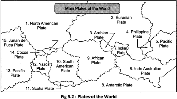
Major plates and minor plates:
The entire earth surface is divided into six main plates : Indian plate, Eurasian plate, American plate, African plate, Antarctic plate and Pacific plate. The minor plates mainly include the Juan – de – Fuca Plate, Cocos Plate, Nazca Plate, Caribbean Plate, Scotia Plate, Arabian Plate, Philippine Plate, North American Plate, Southern American Plate, Indo – Australian Plate, etc.
These main and minor plates found in the world are displayed through the following diagram:
Types of plates:
Plates are of three types depending on their structure:
- Continental Plate.
- Ocean Plate.
- Ocean – Continental Plate.
Plate edges – all the tectonic functions are concluded with the help of these plate edges. These plates margins are of three types on the side is:
1. Constructive Plate Margins:
When two plates are deflected, due to the occurrence of empty space, the magma gets out and accumulates in the form of lava, resulting in regional expansion. Such edges have constructive plates on the side.
2. Destructive Plate Margins:
When two plates are convergent, one plate climbs over the other and the other plate undergoes ablation. The front edge of the avalanche plate melts when it breaks into the mantle. Hence, they are known as destructive plate margins.
3. Protective Plate Margins:
When two plates move along, neither the plate gets eroded nor new materials are created there, so they are called protective plate margins.
RBSE Class 11 Physical Geography Chapter 5 Other Important Questions
RBSE Class 11 Physical Geography Chapter 5 Multiple Choice Questions
Question 1.
Who is the exponent of the Continental Drift Theory?
(a) Snyder
(b) Wegener
(c) Harry Hess
(d) Duck ton
Answer:
(b) Wegener
Question 2.
What was the conjoined landmass called?
(a) Pangaea
(b) Panthalassa
(c) Gondwana Land
(d) Tethys
Answer:
(a) Pangaea
Question 3.
What is the relation between gravity and flotation force?
(a) Revolutions of the Earth
(b) Earth rotation
(c) Gravity
(d) Tidal force
Answer:
(b) Earth rotation
Question 4.
Which force is directed towards the equator ?
(a) The force of gravity
(b) Tidal force
(c) The force of centric
(d) Force of frictional
Answer:
(a) The force of gravity
Question 5.
What is the remaining part of Panthalassa called?
(a) Southern Ocean
(b) Indian Ocean
(c) Pacific Ocean
(d) Arctic Ocean
Answer:
(c) Pacific Ocean
Question 6.
How many main plates are there in the world?
(a) 10
(b) 6
(c) 30
(d) 40
Answer:
(b) 6
Question 7.
Which of the following is not a minor plate?
(a) Nazca
(b) Philippine
(c) Arabian
(d) Antarctic
Answer:
(d) Antarctic
Question 8.
Which configuration is formed from the protective plate margins?
(a) Stapping fault
(b) Transform fault
(c) Reverse fault
(d) Normal fault
Answer:
(b) Transform fault
Question 9.
Which of the following is related to the Himalaya Mountains?
(a) Tethys Sea
(b) Arctic Ocean
(c) Arabian Sea
(d) Mediterranean Sea
Answer:
(a) Tethys Sea
Question 10.
Which of these is a cause of motion in plates?
(a) Pressure
(b) Density
(c) Radioactivity
(d) Earthquake
Answer:
(c) Radioactivity
Matching Type Questions
Question 1.
Match column A to column B in the following:
| Column A (Continental drift thinkers) | Column B (Year) |
| (i) Francis Bacon | (a) 1912 |
| (ii) Snyder | (b) 1620 |
| (iii) Taylor | (c) 1910 |
| (iv) Wegener | (d) 1885 |
Answers:
- (b)
- (d)
- (c)
- (a)
Question 2.
Match column A to column B in the following:
| Column A (Directions) | Column B (Relation) |
| (i) Continents flow to west | (a) Main plate |
| (ii) Continents flow to the equator | (b) Transform fault |
| (iii) African Plate | (c) Destroyer margins |
| (iv) Nazca Plate | (d) Tidal force |
| (v) San Andreas Fault | (e) Minor plate |
Answers:
- (d)
- (c)
- (a)
- (e)
- (b)
RBSE Class 11 Physical Geography Chapter 5 Very Short Answer Type Questions
Question 1.
What are the first – class relief?
Answer:
The continents and the oceans that are found on the earth’s surface are considered to be the first class relief because they were the first to be created.
Question 2.
What are the universal principles of the origin of continents and oceans?
Answer:
In the context of the origin of continents and oceans, the principles known as Continental Drift and Plate Tectonics are universally accepted.
Question 3.
In relation to continental drift, who all have expressed their ideas?
Answer:
In relation to continental drift in Francis Bacon in 1620, Snyder 1885, F.G. Taylor presented their ideas in 1910, but in theory it was rendered in 1912 by Wegener.
Question 4.
Who was Wegener?
Answer:
Wegener was a well – known climatologist and geologist from Germany.
Question 5.
What did Wegener want?
Answer:
Wegener wanted to solve the mysteries of climate change in the past.
Question 6.
What did Wegener consider to be in the Sial and the Sima?
Answer:
According to Wegener, the Sial – built Pangaea is floating seamlessly on the border present in the form of a deep sea bottom.
Question 7.
Write the names of the landmasses on both sides of Tethys Geosyncline.
Answer:
The sea called Tethys divided the Pangaea into the two huge landmasses: Angara land (Laurasia) to the north and Gondwanaland to the south of Tethys.
Question 8.
In which direction did the fragmented landmasses flow?
Answer:
The fragmented plots flowed towards the equator and towards the west.
Question 9.
Which parts drifted towards the equator?
Answer:
India, Australia, Madagascar and Antarctica drifted towards the equator.
Question 10.
What is geodesical proof in favor of Wegener’s theory?
Answer:
The main geodesical proof in favor of Wegener’s theory is that Greenland gradually displaced towards Canada.
Question 11.
Where is the effect of glaciation of the Carboniferous Era found?
Answer:
The effect of the glaciation of the Carboniferous Era is found in India, South America, Africa and Australia.
Question 12.
Which theories are formulated on the basis of plate tectonic theory?
Answer:
Based on the research of plate-tectonic theory, the palaeomagnetism, seismic surveys and sea floor spreading research are formulated.
Question 13.
What does the lithosphere mean?
Answer:
Lithosphere is the outermost layer of the earth consisting of the crust and the upper mantle portion of the earth. Lithosphere is responsible for the hard and rigid surface of the earth on which humans exist.
Question 14.
Why do tectonics processes occur?
Answer:
On the astheno sphere, continuous circulating, refract and rubbing processes of tectonic processes takes place while moving between each other.
Question 15.
Describe the position of the Caroline Plate.
Answer:
The Caroline plate is located in the north of New Guinea, between the Philippine and the Indian Plate.
Question 16.
Where is the Cocos Plate situated?
Answer:
Cocos Plate is located in the middle of the mid America and the Pacific Ocean plate.
Question 17.
Explain the position of the Nazca plate.
Answer:
Nazca plate is located between the South America plate and the Pacific Ocean Plate.
Question 18.
Where is the Philippine plate located?
Answer:
The Philippine plate is located between the Asia – Pacific and the Pacific Ocean Plate.
Question 19.
What is the continental plate?
Answer:
Continental plate is the plate associated with continent. The whole or most part of this plate is mostly the land.
Question 20.
What is Ocean Plate?
Answer:
The whole or most part of the plate which comes under the ocean bottom is called the ocean plate.
Question 21.
What is plate margins?
Answer:
Terrestrial rigid parts are called the plates. The edges of the lithosphere are called the plate margins.
Question 22.
What is plate tectonics?
Answer:
Terrestrial rigid parts are called the plates. The study related to the nature and flow of these plates is called the plate tectonics.
Question 23.
Which is the fully – oceanic plate? What is its extension ?
Answer:
The Pacific Ocean Plate is completely Oceanic. This extends from eastern Pacific Ridge to the west on the entire Pacific Ocean.
Question 24.
What does plate convergence mean?
Answer:
When two plates move towards each other from different directions, one of the plates climbs over the other. Such process is called convergence.
Question 25.
Where is the volcanic chain available?
Answer:
Island and volcanic range is found on the margins of the Pacific Ocean Plate.
RBSE Class 11 Physical Geography Chapter 5 Short Answer Type Questions (SA-I)
Question 1.
Define the Pangaea and write a brief comment on its division.
Answer:
According to Wegener, Pangaea is the term used for the joint stretch, which represents the vast United Continental part.
Division of Pangaea:
division started in the Carboniferous Era. It was first divided into two parts, the northern part of which was called Angara land (Laurasia) and the southern part was called Gondwanaland. Angara land and Gondwanaland were redistributed into smaller parts in the Jurassic Era. America was divided in the Eocene Era. This division was completed by the Pleistocene Era.
Question 2.
Describe the forces responsible for the flow of continents.
Answer:
Wegener considered the following two forces responsible for the flow of continents.
- Gravity and flotation force.
- Tidal force.
1. Gravity and flotation force:
This force led the movement of the land towards the equator (north side). Due to this force, India, Australia, Madagascar and Antarctica were created.
2. Tidal force:
Due to this force, the land was moved westwards, which led to the creation of North and the South America.
Question 3.
Explain the alignment of the mountains with the help of an illustration.
Answer:
The alignment of mountains included in the geographical evidence of Wegener’s theory has been shown in the following map.
Question 4.
Explain the geological evidence of Continental Drift Theory.
Answer:
The geologic proof of the Continental Drift Theory presented by Wegener is:
- Structural similarities
- Strati graphical similarities
1. Structural similarities:
In the shell structure of the coastal areas on either side of the Atlantic Ocean, there is a similarity in the structure that both these seas were once adjacent to each other.
2. Strati graphical similarities:
The similarity found in the order of the different layers of rocks on both sides of the Atlantic Ocean is the evidence of their close proximity.
Question 5.
Describe the Geodesical criticism of the Continental Drift Theory.
Answer:
According to Wegener, displacement towards the equator is due to the force of gravity of the sun and the moon. While mathematicians have proven that for the displacement of the land to the equator, the amount of gravitational force needed is 10 billion times more than the current force. Mathematic critics believe that it is impossible to have such a force. However, if was it possible, then due to that much force, the rotation of the earth would have been interrupted.
Question 6.
Explain the reason for speed in the plates.
Answer:
Geothermal energy is generated from the hot spots located in the Earth. The radio waves raise up in the form of vascular waves and cause movement in the plates. The flow of convection waves directly beneath Plates gives them horizontal motion. The main activity of the convection wave is to enable the arrival of magma from within the area of the middle ocean vents and to make it reach the mantle by placing the plate down on converging side.
Question 7.
Explain the importance of plate tectonics.
Answer:
The principle of plate tectonics is of the utmost importance. This theory has proved to be the most meaningful in explaining the origin of the continents and the oceans as also the description of earthquake, volcanic activity, origin of island arc and the structure of mountains and their types.
RBSE Class 11 Physical Geography Chapter 5 Short Answer Type Questions (SA-II)
Question 1.
Give a brief overview of the important small plates of the lithosphere.
Answer:
According to the theory of plate tectonics, the lithosphere is divided into six major plates and twenty small plates. The minor plates are the following:
1. Cocos Plate:
Its position is between the Central America and the Pacific Ocean Plate.
2. Nazca Plate:
It is between the South America and the Pacific Ocean Plate.
3. Arabian Plate:
This includes mostly the peninsular parts of Arabia.
4. Philippine Plate:
It is located between the of Asia – Pacific and Pacific Ocean Plate.
5. Caroline Plate:
Located in the north of New Guinea between the Philippine and the Indian Plate.
6. Fuji Plate:
Its position is in the north – east of the continent of Australia.
Question 2.
Explain the concept of Sea floor spreading in brief.
Answer:
Sea floor spreading:
Flat spaces are formed in the opposite direction of two plates on the divergent edges. In these empty spaces, the magma rises above the convection function and the lava gets deposited above, which creates new styles.
The continuation of this process keeps the order of forming the new shell crust. As a result, the ocean bottom is expanding. Like lava on both sides of the mid – Atlantic ridge is creating new scarf, which is spreading the Atlantic Ocean. With the expansion of the ocean bottom, the concept of the continent and ocean mobility is also proved.
Question 3.
How does the theory of plate tectonics emphasize the concept of convection currents?
Answer:
The principle of plate tectonics is a universal principle that relates to the earthquake incidents, volcanic activity, mountain formation, island creation, etc. Due to this principle, today, most of the geographers, and geologists have embarked on re – accepting the truth of continental displacement. At present, the scholars are unanimous on all other issues except propelling force. Recent research studies have revitalized the concept of thermal convection currents in relation to plate tectonics.
RBSE Class 11 Physical Geography Chapter 5 Essay Type Questions
Question 1.
Explain the plate margins.
Or
How many types of plate edges are there? Explain them.
Answer:
Plate tectonic theory is dependent on plate margins because most tectonic events occur with the help of plate edges. These plate margins are divided into the following parts:
1. Constructive Plate Margins:
With the help of these edges, two plates are deflected, due to which the empty space is formed. There is a regional expansion due to the magma coming out and accumulating in the form of lava. Therefore they are called creative edges. They are found on the Atlantic Ridge.
2. Destructive Plate Margins:
Due to the convergence of two plates, with the help of . these edges, one plate climbs over the other and the second plate undergoes ablation. The front edge of the avalanche plate melts when it breaks down into the mantle. Hence it is called the Destructive Strand. This molten substance reaches out of weak crust and creates volcanic and island arc. Island arc and volcanic range is wide on the shores of Pacific Ocean Plate.
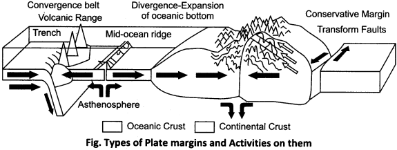
3. Conservative Plate Margins:
With the help of these edges, two plates move side by side. There is neither plate erosion nor new material is created there. Only transform faults are formed. Hence it is called the protective shore. In the western part of North America, San Andreas is the protective side of the two sub-plates, with the help of prolapse. These form of plate margins are shown with the help of the above figure.
Question 2.
Explain the differences between the principle of continental drift theory and plate tectonics theory.
Answer:
Major differences in the principles of continental drift theory and plate tectonics are as follows:
| Continental Drift Theory | Plate Tectonics Theory |
| 1. This principle was interpreted by Alfred Wegener in 1912. | 1. This theory was enumerated by Mackenzie, Parker and Morgan in 1967. |
| 2. The continental drift theory interprets the origin and distribution of the continents and the oceans. | 2. The theory of plate tectonics relates to various geological phenomena. Through this theory, detailed explanation of the origin of the continents and oceans, mountain formation, earthquake and the origin of volcano are explained. |
| 3. According to the continental drift theory, all the continents were associated with each other in the early period. This connected site has been called Pangaea. | 3. According to this theory, the continents and oceans are located on irregular and different shaped plates and are dynamic. |
| 4. According to this theory, all the landmarks were affiliated in the form of Pangaea. Pangaea was later divided. Its northern part is called Laurasia and the southern part is Gondwanaland. This incident took place some 200 million years ago. | 4. According to this theory, the Earth’s lithosphere is divided into 6 main plates and 20 small plates. Newly formed mountain ranges, trenches and rift valleys delineate these main plates. |
| 5. According to this theory, the stretch marks are made of sial which floats on a high density border. That is, only the stretches are dynamic. | 5. According to this theory, a tectonic plate which is made up of continental and oceanic tracts, is dynamic in horizontal form as a solid unit. |