Rajasthan Board RBSE Class 11 Physical Geography Chapter 8 Major Landforms
RBSE Class 11 Physical Geography Chapter 8 Text Book Questions
RBSE Class 11 Physical Geography Chapter 8 Multiple Choice Questions
Question 1.
Which are the First Order Relief?
(a) Delta and Valley
(b) Continent and Ocean
(c) Mountain and Plateau
(d) Plains and Coast
Answer:
(b) Continent and Ocean
Question 2.
Which of these is not endogenetic force?
(a) Volcano
(b) Earthquake
(c) Mountainization
(d) Erosion
Answer:
(d) Erosion
Question 3.
Which is an example of Inter mountain Plateau out of the following?
(a) Patagonia Plateau
(b) Tibetan Plateau
(c) Laos Plateau
(d) Malagasy Plateau
Answer:
(b) Tibetan Plateau
Question 4.
Which is an example of Accumulated Mountain out of the following?
(a) Himalaya
(b) Fujiyama of Japan
(c) Ural
(d) Andes
Answer:
(b) Fujiyama of Japan
Question 5.
Which is an example of Humid Plateau out of the following?
(a) Potwar Plateau
(b) Gobi Plateau
(c) Cherrapunji Plateau
(d) Tarim Plateau
Answer:
(c) Cherrapunji Plateau
RBSE Class 11 Physical Geography Chapter 8 Very Short Answer Type Questions
Question 1.
Which are the new mountains of the world?
Answer:
Himalaya, Ural and Andes, etc. are the fold mountains which are the new mountains of the world.
Question 2.
What is the Accumulated Mountain?
Answer:
Mountains which are formed by the collected debris and deposited substances accumulated in the form of large piles by air, river, glacier, waves and volcano.
Question 3.
In which type of valley does the Narmada River flow?
Answer:
Narmada river flows from east to west through the Rift valley formed by the process of faulting. .
Question 4.
What is Residual Mountain ?
Answer:
Residual Mountains are the remnants of old mountains which have been worn down by agents of denudation. They are usually hard resistant rocks that are left standing after the surrounding areas have been reduced by agents of denudation.
Question 5.
What is Piedmont Plateau?
Answer:
Plateau which is located in the foothills of the mountains having the mountain at one of its side and the sea or plain at the other side is called the Piedmont Plateau.
RBSE Class 11 Physical Geography Chapter 8 Short Answer Type Questions
Question 1.
Write the names of Hercynian Mountains.
Answer:
About 22 million years ago, folded mountain building collisions are known by the names Hercynian, Variscan and Armorican. Altai, Khingan, Nanshan, Eastern Cordillera Mountains of Australia, and Panine and Harz Mountains in Europe are formed from them.
Question 2.
Explain Glacial Plateau.
Answer:
Plateaus which are formed by the erosion caused by glaciers in high latitudes or high relief regions are called the Glacial Plateaus. This type of plateau includes Plateau of Garhwal, Plateau of Labrador, Plateau of Scandinavia, Plateau of Alaska, Plateau of Antarctica, South – Eastern Plateau of Africa, Prussian Plateau in Germany, Gulmarg Plateau in Kashmir.
Question 3.
What is Inter – mountain Plateau?
Answer:
When the plateau is surrounded by mountains from four or two sides, then due to being located between the mountains, it is called the Inter – mountain Plateau. These plateaus are formed with the formation of fold mountains by endogenetic force. This plateau is originated mainly in the form of a central body. In these plateaus, the main examples are Tibetan plateau between Himalaya and Kunlun mountains, Sedaam plateau between Kunlun and Nanshan mountains, Iran plateau between Elburz and Zagros mountains, Anatolia plateau between Pontik and Taurus mountains.
Question 4.
What is the Ansequent Valley?
Answer:
In the valley developed before the uplift of a landmass, even after the uplift of the land, the river flows in pre – built valley, then it is called the Ansequent Valley. These valleys are formed when the preceding stream retains its surface even on the uplifting of landmass.
Question 5.
What is the Mature Plateau? Give examples.
Answer:
In these plateaus with rough and uneven terrain, the ridges are of steep slope. Their sharp peaks expand more. Such plateaus are called the Mature Plateaus. The structure of these plateaus varies in arid and humid regions. The edges of these plateaus generally look like stairs. Appalation Plateau is an example of this type of plateau.
RBSE Class 11 Physical Geography Chapter 8 Essay Type Questions
Question 1.
Classify the mountains.
Answer:
Classification of mountains:
Mountains are the Second Order Relief. These are originated due to endogenetic forces. All the mountains found the world are not similar. Variations are found in their formation process, height, age, location, structure and texture. On the basis of these factors, the mountains found in the world are classified into the following types:
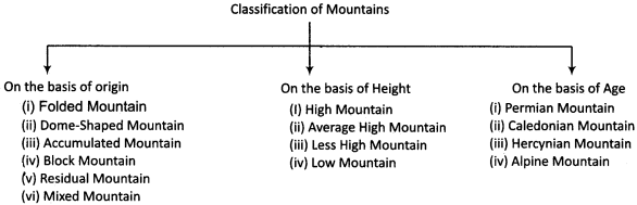
In the classification of mountains made on these different bases, the classification made on the basis of origin is significantly important. A brief description of this classification of mountains is as follows:
1. Folded Mountain:
Folded mountains are defined as the formation of folding of crustal rocks by compressive forces generated by endogenetic forces coming from within the earth. Raised part by compression force is called anticline and stuck down part is called syncline. Quick geologic movements lift up the folds of anticline and syncline and over the period of time fold mountains are uplifted. Himalaya, Ural and Andes mountains are the examples of folded mountains. These are the new mountains of the world and fossils are not found in their rocks.
2. Dome – Shaped Mountain:
The boiling hot magma inside the earth makes every effort to come on the surface of earth. When this magma does not come out, then the surface rocks elevate in the shape of a dome. Henry and Unta mountains in Utah state of North America are the examples of this type of mountain.
3. Accumulated Mountain:
These mountains are formed by the collected debris and deposited substances accumulated in the form of large piles by air, river, glacier, waves and volcano. Fujiyama mountain of Japan, Vesuvius mountain of Italy and Kilimanjaro mountain of Africa are the volcano accumulated mountains.
4. Fault or Block Mountain:
When the intermediate part between two parallel cracks is elevated upwards or both the two sides of the middle part are stuck downwards, then the Block Mountain is originated. Due to their formation by faults, these mountains are also called the Fault Mountains.
5. Residual Mountain:
Residual mountains are the reminants of old mountains which have been worn down by agents of denudation like river, wind, waves, glacier, etc. They are usually hard resistant rocks that are left standing after the surrounding areas have been reduced by agents of denudation. When the river erodes the plateau terrain and reduces it to the flat plain, but cannot erode the part of intermediate rocks, then it takes the form of Residual Mountain.
6. Mixed Mountain:
Mountain which is alike all types of mountains or more than one type of mountain is called the Mixed Mountain.
Question 2.
Classify the plateaus on the basis of origin.
Answer:
Plateaus are the Second Order Relief on the earth’s surface. They come on the second place after the mountains. The condition of plateaus found in the world varies according to their origin, climatic conditions and stages of development. Plateaus are classified on these bases. The classification of plateaus on the basis of their origin is described as follows:
1. Lava Plateau:
Lava plateaus are slow accumulation of lava eruptions from old volcanic regions or formed by lava eruption from open cracks or craters. In this type of plateau, volcano originated by sudden processes of endogenetic forces contributes significantly. Based on the nature of lava as liquid or thick, the plateau can be more or less extensive as well as higher or lower. The plateau of Columbia and the Deccan plateau of South India are the main examples of this type of plateau.
2. Glacial Plateau:
Plateaus which are formed as a result of erosion caused by the process of glacial movement in high latitude regions or high relief regions are called the Glacial Plateaus. In these plateaus, due to the dribble by erosion of rock ranges, flat structure is formed. Examples of this type of plateau are Plateau of Garhwal, Plateau of Labrador, Plateau of Scandinavia, Plateau of Alaska, South – Eastern Plateau of Greenland, Plateau of Canada, Prasha Plateau of Germany and Plateau of Antarctica.
3. Air – Made Plateau:
Plateaus which are formed by the extreme deposition of soil particles carried by the wind are called the Air-Made Plateaus. These plateaus are formed by the sand accumulated in large amount due to the transportation and deposition by wind. This type of plateau includes Potwar Plateau in Pakistan, Loess Plateau in China, Plateau of Africa and North America.
4. Water – Made Plateau:
Plateaus which are formed when the regular sea level is elevated up due to the internal movements of accumulated sediments in sea part or in geosycline, are called Water-Made Plateaus. The sediments accumulated at bottom of the sea are the result of force of erosion. These sediments are uplifted by the actions of endogenetic force due to which these plateaus come into existence. This type of plateau includes Vindhyachal Plateau of India, Plateau of Cherrapunji and Shaan Plateau in Myanmar.
Question 3.
Analyze the classification and importance of the plains.
Answer:
Definition of Plains:
The surface terrain with low relief and relatively flat, regular and gentle slope is called the Plains.
Classification of Plains:
In the plains found in the entire world, variations are found in their condition, structure and factors of their formation. For this reason plains are of different types. The formation process of plains takes place mainly by the actions of erosion and deposition. Considering these two actions as the basis, the plains are classified as follows:
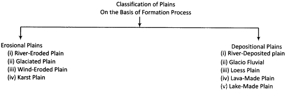
1. Erosional Plains:
At the end of the erosion cycle, all the reliefs are converted into plains. The plains formed by this are divided into the following parts:
(a) River Eroded Plains:
The uneven surfaces coming in the path of rivers are made flat by them through erosion, thereby forming the plains.
Hard resistant rock:
Monadnock in the form of mound is seen here and there in these plains. Paris and London Basin are the examples of this type of Plains.
(b) Glaciated Plains:
Snow – cover prevails on the high mountain peaks and high latitudes. Due to rubbing and friction, the surface beneath the snow gets flat. Glaciated plains are found in Canada, Sweden and Finland.
(c) Wind – Eroded Plains:
The rock particles which are soft and broken by mechanical weathering are flown away by the wind. This wind causes the abrasion of the elevated rocks coming in its path. By this action, the Wind Eroded Plain is formed, which is called the Pediplain.
(d) Karst Plains:
In the region of lime – rocks, when the surface unevenness ends in J the last stage of the cycle of erosion of underground water, the Karst Plain is formed. Its examples are found in Nainital and Almora of India, in lime regions of Yugoslavia and France.
2. Depositional Plains:
(a) River – Deposited Plains:
These plains are formed by the deposition of eroded debris which is carried away by the flowing rivers from high parts to lower parts. According to the context, these plains are called the Piedmont Plains, Flood Plains and Delta Plains. The deltaic plains of the Ganga, Brahmaputra and Nile rivers are highly fertile and densely populated.
(b) Glacio – Fluvial Plains:
These plains are formed from the deposition by glaciers. Dense – ceramic plains are formed by the accumulation of pebbles, stones and gravel carried by the glaciers below the snow – line. Outwash plains are formed from the deposition of fine soil by melted water of glaciers.
(c) Loess Plains:
These plains are formed from the accumulation of fine soil carried by wind in desert regions. Loess plains are prominent in China, Argentina, Caspian Sea.
(d) Lava – Made Plains:
These plains are formed when the lava, ashes, fine rock particles erupted by the volcanic eruption get accumulated at an extensive area. Lava – Made Plains are found in South India.
(e) Lake – Made Plains:
When the lake is filled by sediment deposition of rivers, then the accumulated sediments take the form of the fertile plain. When the lake bottom is elevated up due to internal movements, then its water spreads around and the lake bottom turns into the plain. Plain of Hungary, Prairie region of America are Lake – Made Plains.
Importance of Plains:
The importance of the plains can be understood by the following points:
- About more than 80% population of the world resides in the plains.
- The plains have played an important role in the rise of many civilizations.
- The plains are the most suitable place in terms of agricultural processes.
- The plains are the most suitable in terms of transportation due to their flat structure.
- These are the ideal place for human activities.
- They provide an ideal condition in terms of irrigation, pasture, house construction, railway track and roadway etc.
RBSE Class 11 Physical Geography Chapter 8 Other Important Questions
RBSE Class 11 Physical Geography Chapter 8 Multiple Choice Questions
Question 1.
Into how many categories are the land forms divided?
(a) 2
(b) 3
(c) 4
(d) b
Question 2.
Which order relief are the plains?
(a) First Order
(b) Second Order
(c) Third Order
(d) None of these
(b) Second Order
Question 3.
An example of the Folded Mountain is:
(a) Aravalli
(b) Fujiyama
(c) Uinta
(d) Himalaya
(d) Himalaya
Question 4.
Where is Kilimanjaro Mountain located?
(a) In India
(b) In America
(c) In Africa
(d) In Europe
(c) In Africa
Question 5.
The one which is not included in the Alpine Mountain Period is :
(a) Kunlun
(b) Altai
(c) Alps
(d) Pyrennes
(b) Altai
Question 6.
Which type of plateau is Appalachian Plateau?
(a) New Plateau
(b) Mature Plateau
(c) Old Plateau
(d) Rejuvenated Plateau
(b) Mature Plateau
Question 7.
Karst Plains are formed by:
(a) River
(b) Glacier
(c) Wind
(d) Underground Water
(d) Underground Water
Question 8.
Which has been called the Cradle of Civilizations?
(a) Mountains
(b) Plateaus
(c) Plains
(d) Oceans
(c) Plains
Matching Type Questions
Match Column A with Column B:
Question A.
| Column A (Land form) | Column B (Relation) |
| (i) Continent | (a) Third Order Relief |
| (ii) Mountain | (b) Air – Made Plateau |
| (iii) Delta | (c) Glacial Plateau |
| (iv) Plateau of Labrador | (d) First Order Relief |
| (v) Loess Plateau | (e) Second Order Relief |
Answers:
- (d)
- (e)
- (a)
- (c)
- (b)
Question B.
| Column A (Name of Mountain) | Column B (Mountain – Building Period) |
| (i) Aravalli Mountain | (a) Alpine Mountain Period |
| (ii) Appalachian Mountain | (b) Hercynian Mountain Period |
| (iii) Nanshan Mountain | (c) Caledonian Mountain Period |
| (iv) Balkan Mountain | (d) Archean Mountain Period |
Answers:
- (d)
- (c)
- (b)
- (a)
RBSE Class 11 Physical Geography Chapter 8 Very Short Answer Type Questions
Question 1.
Why are the land forms formed on the earth’s crust?
Answer:
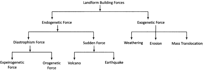
The formation of different land forms on the earth’s crust is a result of interactions between the internal and external forces of the earth.
Question 2.
What is the definition of the mountains given by Finch?
Answer:
According to Finch, “Mountains are 600 meters above sea level or higher, and with the slope of 260 degree to 350 degree.”
Question 3.
On which basis are the mountains classified?
Answer:
Mountains are classified on the basis of their formation process, their height, age, location, structure and texture.
Question 4.
What is Syncline?
Answer:
Due to the process of compression, when the rocks take the curved form, then a downward and U – shaped fold in the layers of rocks in the earth’s surface is called the Syncline.
Question 5.
Name the major Accumulated Mountains of the world.
Answer:
The major Accumulated Mountains of the world include Fujiyama Mountain of Japan, Vesuvius Mountain of Italy and Kilimanjaro Mountain of Africa.
Question 6.
What does the term Block Mountain mean?
Answer:
When the intermediate part between two parallel cracks is elevated upwards or both the two sides of the middle part are stuck downwards, then the mountain formed by this process is called Block or Faulted Mountain.
Question 7.
Into which types are the mountains classified on the basis of age?
Answer:
On the basis of age, the mountains are classified into the four mountain building periods : Archean Mountain Period, Caledonian Mountain Period, Hercynian Mountain Period and Alpine Mountain Period.
Question 8.
Which are the mountains formed in the Alpine Mountain Period? Name them.
Answer:
The major mountains which were formed in the Alpine Mountain Period are Himalayas, Arakan Yoma, Elburz, Hindu Kush, Rockies, Andes, Alps, Balkan and Pyrennes.
Question 9.
Into how many categories are mountains classified on the basis of their height?
Answer:
On the basis of height, mountains are classified into four parts – High Mountains, Average High Mountains, Less High Mountains and Low Mountains.
Question 10.
What does the term High Mountain mean?
Answer:
The mountains whose height is more than 6000 feet or more than 2000 meters are called High Mountains.
Question 11.
Define the Plateau.
Answer:
Elevated part above the earth surface, whose top surface is flat and broad, and the edges are with steep slope, is called the Plateau.
Question 12.
Into how many parts are the plateaus classified on the basis of their origin?
Answer:
On the basis of origin, the plateaus are classified into four parts – Lava – Made Plateau, Glacial Plateau, Air – Made Plateau and Water – Made Plateau.
Question 13.
What does the term Lava – Made Plateau mean?
Answer:
The plateau which is formed when the lava erupted from the volcanic activity extends over a large area, and over the period of time, it cools downs and solidifies, is called the Lava – Made Plateau.
Question 14.
Into how many types are the plateaus classified on the basis of location?
Answer:
On the basis of location, the plateaus are classified into three parts – Intermountain Plateau, Piedmont Plateau and Continental Plateau.
Question 15.
What are Continental Plateaus?
Answer:
The plateaus which extend over the entire part of a country or continent are called Continental Plateaus.
Question 16.
What is a Snowy plateau?
Answer:
The plateau whose most of the part remains covered with snow round the year due to extreme cold is called a Snowy Plateau.
Question 17.
Into how many types are the plateaus classified on the basis of stage of development?
Answer:
On the basis of the stage of development, the plateaus are classified into four parts: New Plateau, Mature Plateau, Old Plateau and Rejuvenated Plateau.
Question 18.
What does the term Rejuvenated Plateau mean?
Answer:
Plateaus which attain the old stage are re-elevated due to the internal movements and process of erosion re – starts on them, then such plateaus are called Rejuvenated Plateaus.
Question 19.
What is a Plain? How many types of plains are there?
Answer:
The surface terrain with low relief and relatively flat, regular and gentle slope is called the Plain. On the basis of formation process, the plains are of two types: Erosional Plains and Depositional Plains.
Question 20.
What is a Pediplain?
Answer:
The rock particles which are soft and broken by mechanical weathering are blown away by the wind. This wind causes the abrasion of the elevated rocks coming in its path. The plains formed by this action are called the Pediplain.
Question 21.
What does the term Piedmont Mountain mean?
Answer:
When the flowing rivers carry away the eroded debris from the high parts and their deposition is made in the lower parts of mountains, then the plains formed by this action are called Piedmont Plains.
Question 22.
What is a Loess Plain?
Answer:
The plains which are formed from the accumulation of fine soil blown by wind in desert regions are called Loess Plains.
Question 23.
Name the Lake – Made Plains.
Answer:
Plain of Hungary, Prairie region of America are included in the Lake-Made Plains.
Question 24.
Why are plains called the Cradle of Civilizations?
Answer:
The major civilizations of the world like Indus Valley Civilization, Mesopotamian Civilization, Nile Valley Civilization had developed in the plains. Thus, the plains are called the Cradle of Civilizations.
Question 25.
What is a Rift Valley?
Answer:
A steep – sided valley formed by the downward displacement of a block of the earth’s surface between nearly parallel faults is called the Rift Vallay.
Question 26.
Into how many types are the valleys classified on genetic basis?
Answer:
On genetic basis, the valleys are classified into Consequent Valley, Subsequent Valley, Obsequent Valley, Resequent Valley and Insequent Valley.
Question 27.
What is Consequent Valley?
Answer:
Consequent Valley:
The valley formed by the initial streams that originate in a particular region in accordance with the initial slope of the land.
Question 28.
What is Subsequent Valley?
Answer:
Subsequent Valley:
The valley formed by streams originated after the consequent stream and joining the master consequent at right angles.
Question 29.
Which problems have been solved by the concept of Plate Tectonics?
Answer:
The concept of Plate Tectonics has helped in explaining the processes like mountainization, earthquake, volcano and Continental Drift.
RBSE Class 11 Physical Geography Chapter 8 Short Answer Type Questions (SA-I)
Question 1.
Present the land form – building forces through the table.
Question 2.
What are the differences between the Dome – shaped Mountain and Block Mountain.
Answer:
The following differences are found between the Dome – shaped Mountain and Block Mountain.
| Dome – Shaped Mountain | Block Mountain |
| 1. These mountains are formed due to the pressure created upwards by the internal part of the earth’s surface. | 1. These mountains are formed due to the action of faulting. |
| 2. In this, the terrain elevates up in the shape of a dome. | 2. In this, there is no certain shape of the terrain elevating up or sinking down. |
| 3. In this, a large part elevates upwards. | 3. In these mountains, the parts elevating up or sinking down are usually less in size. |
Question 3.
How many types of mountain-building movements are there? Explain.
Answer:
The formation of mountains is not a sudden process, but the mountains are formed as a result of a long process. This formation of mountains occurred in various mountain – building periods. There are four periods of mountain – building on the earth’s surface:
1. Archean Mountain Period:
This mountain – building movement occurred about 40 million years ago in Cambrian period.
2. Caledonian Mountain Period:
This, movement occurred about 32 million years ago.
3. Hercynian Mountain Period:
This movement occurred about 22 million years ago.
4. Alpine Mountain Period:
This movement occurred about 3 million years ago.
Question 4.
Explain the importance of Plateaus.
Answer:
The importance of plateaus is significant, which is being explained by the following points:
- Fertile soil is found on the plateaus which is useful for intensive agriculture.
- Plateaus are the store – house of many precious minerals.
- Water – reservoirs are built on their hard surface.
- Waterfalls are formed by the rivers descending from the steep slopes of the plateaus.
- The means of transportation are more developed on the plateaus than the mountains.
- Plateaus are more populated than the mountains.
Question 5.
Explain the formation of valleys.
Answer:
Valley is generally considered to be an unassertive topography of river. The formation of valleys also occurs due to diastrophism. Valleys are also formed by underground water and glaciers. Valley is basically an elongated depression on the earth’s surface, usually between the ranges of hills or mountains which is created by tectonic events or external forces. Valley presents various forms from its stage of development to its last stage.
Question 6.
Explain the valleys formed by tectonic events.
Answer:
The valleys formed by movements caused due to endogenetic forces come under the category of tectonics. This type of valley is classified into two parts:
- Synclinal Valley
- Rift Valley.
1. Synclinal Valley:
Curved folds occurred in rocks due to compression force of tectonic action, which causes anticline and syncline. Synclinal valley is formed in subsided part of the folding.
2. Rift Valley:
Rift Valley is a steep – sided valley formed by the downward displacement of a block of the earth’s surface between two nearly parallel faults. Valley of Narmada River is an example of rift valley.
Question 7.
Explain the classification of valleys on the basis of stages of development.
Answer:
Valleys pass through various stages from the formation stage to reach the final stage. In this, the process of erosion and the position of slope vary. On this basis, the valleys are classified into the following types:
- Youth Valley
- Mature Valley
- Old Valley
1. Youth Valley:
Slope of valley is steep in the youth stage, thus, deep valley is formed due to more of vertical erosion.
2. Mature Valley:
Slope of valley gets gentle in the mature stage, thus, valley becomes broad due to more of lateral erosion.
3. Old Valley:
This is the last stage of valley. The slope of valley gets extremely gentle in this stage and the valley starts becoming flat.
Question 8.
Explain the classification of valleys according to the change in base-surface?
Answer:
In the valleys, from the initial stage to the development, changes also occur in the surface position. Considering the change in base – surface as the basis, the valleys are classified into the following parts:
- Drowned Valley
- Rejuvenated Valley
1. Drowned Valley:
A submerged coastal valley formed as a result of rise in water level of a ocean or lake or sinking down of proximal place is called Drowned Valley.
2. Rejuvenated Valley:
On the fall in sea level, river rejuvenation involves a renewed period of vertical erosion to achieve a new and lower base level, which is called the Rejuvenated Valley.
RBSE Class 11 Physical Geography Chapter 8 Short Answer Type Questions (SA-II)
Question 1.
Classify the mountains according to their height.
Answer:
The height of mountains is not found similar in the entire world. Considering the height of mountains as the basis, the mountains are classified into the following types:
- High Mountains
- Average High Mountains
- Less High Mountains
- Low Mountains
1. High Mountains:
The mountains whose height is more than 6000 feet or more than 2000 meters are called High Mountains.
2. Average High Mountains:
The mountains whose height ranges between 4500 feet to 6000 feet or between 1500 meters to 2000 meters are called Average High Mountains.
3. Less High Mountains:
The mountains whose height ranges between 3000 feet to 4500 feet or 1000 meters to 1500 meters are called the Less High Mountains.
4. Low Mountains:
The mountains whose height ranges between 2000 feet to 3000 feet or between 700 meters to 1000 meters are called Low Mountains.
Question 2.
Explain the influence of mountains on human life.
Answer:
The condition of mountains found in any nation or region affects the human activities of that region, their social status, tourism, water availability and religious structure. The useful or beneficial effects of mountains on the human life are as follows:
- Several tourist centers develop in the mountains which promote tourism.
- Mountains, provide facilities like recreation, health benefits and adventurous mountaineering.
- Mountains determine the natural boundaries.
- Mountains play an important role in controlling the climate.
- Mountains occupy an important place from security and strategic perspective.
- Rivers from the mountains are the source of water for large populations.
- Various types of medicinal plants are obtained in mountainous regions.
- The dwellers of mountainous regions are adventurous, courageous, hard working, healthy and gentle.
- Mountains are important from the religious and spiritual perspective.
- Many types of resources are obtained from mountains.
- Mountains being peaceful and isolated place, they have been the spiritual center and land of penance for the sages since the ancient period.
- Many holy pilgrim destinations are developed in the mountains.
Question 3.
Explain the classification of plateaus on the basis of climate.
Answer:
The type of climate plays an important role in the formation of plateaus found in various parts of the world. The climatic conditions determine the structure of plateaus. Considering the climatic conditions of the world as the basis, the plateaus are classified into the following parts:
- Humid Plateau
- Arid Plateau
- Snowy Plateau
1. Humid Plateau:
The plateaus with usually 50% humidity and good rainfall are called the Humid Plateaus. In these plateaus, the rivers are fast flowing, narrow and forceful. Thus, humid plateaus are eroded by them. This type of plateau includes Plateau of Cherrapunji, Plateau of Malagasy, Eastern Plateau of Australia, Plateau of Otago in New Zealand.
2. Arid Plateau:
These plateaus are formed due to excessive amount of evaporation as compared to the rainfall. Most of the plateaus of this type are found on the Western edges of the continents near the Cancer and Capricorn Lines. This type of plateau includes Plateau of Tarim, Plateau of Potwar, Plateau of Gobi, Plateau of Sedaam.
3. Snowy Plateau:
These plateaus are formed in the high latitudes or high regions and most of the part of these plateaus remains covered with snow round the year due to extreme cold. This type of plateau includes Plateau of Greenland, Plateaus of Antarctica and southern part of the plateau of Patagonia.
Question 4.
Explain the valleys formed by external forces.
Answer:
The valleys formed by external erosion forces are classified into the following parts:
- River Valley
- Glacial Valley
- Blind Valley
1. River Valley:
River Valley is formed by the vertical and horizontal erosion caused by the flow of rainwater on the earth’s surface. The development of river valley lies on its depth and breadth. The depth and breadth of the valley depend on the surface structure, slope position arid water velocity. The V-shaped valley is formed in the initial stage by river water.
2. Glacial Valley:
U – shaped valleys are formed by the process of glaciations. They have a characteristic U shape, with steep, straight sides and a flat or rounded bottom. Glacial valleys are formed when a glacier travels across and down a slope, carving the valley by the action of scouring.
3. Blind Valley:
A river flows over a limestone basin until the joints have opened up sufficiently and the stream disappears down a shallow hole. The valley downstream is dry and erosion stops here.
Question 5.
Classify the valleys on genetic basis.
Answer:
On genetic basis, the valleys are classified into the following types:
1. Consequent Valley:
The valley formed by the initial streams that originate in a particular region in accordance with the initial slope of the land is called Consequent Valley. These valleys develop mainly in newly formed parts, volcanic regions and coastal plains. These valleys develop on the initial surface of elevated terrain in accordance to the slope.
2. Subsequent Valley:
The valley formed by streams originated after the consequent stream and joining the master consequent at right angles is called Subsequent Valley. These valleys are found usually in regions with soft rocks.
3. Obsequent Valley:
The valley formed by streams flowing in a direction opposite to that of the dip of the rock strata, i.e. opposite to the master consequent stream is called Obsequent Valley. After the formation of subsequent valleys, river tributaries of the river flowing in them are developed.
4. Resequent Valley:
The valley formed by streams which flow in the direction of the initial consequent stream but join the subsequent streams, thereby developing in response to a new base level.
5. Insequent Valley:
The river valley that remains unaffected by the regional slope and geological structure is called Insequent Valley.
RBSE Class 11 Physical Geography Chapter 8 Essay Type Questions
Question 1.
Define the mountains. Also explain different mountain – building movements.
Or
Explain different mountain-building movements responsible for the formation of mountains.
Answer:
Highly elevated part above the earth surface having the narrow peak and steep slope, such a land form is called a Mountain. A scholar named Finch defined the mountain as, “Mountains are 600 meters above sea level or higher, and with the slope of 260 degree to 350 degree.”
Mountain – Building Movements:
The formation of mountains in the entire world is not a sudden process, but it is the result of a long – term process that took place at different times. Four major mountain – building movements have occurred till now. There has been a long, quiet period between these movements. Compression force must have been stored during the quiet – period, as a result of which, these movements got into action. The periods of mountain – building are classified into the following parts:
- Archean Period
- Caledonian Period
- Hercynian Period
- Alpine Period
1. Archean Period:
This event of mountain – building took place about 40 million years ago. This is an event of Cambrian Period. Under this period, the mountains that were formed are Fenno – Scandinavia in Europe; Aravalli Mountain, Dharwad, Chota Nagpur, Cudappah, Mountains of Eastern Ghat in India.
2. Caledonian Period:
This period of mountain – building movement took place about 32 million years ago. Due to this movement, there was a lot of change in Europe. Abundant minerals are found in the mountains of this period. The mountains that were formed by this movement are Appalachian in America, Scottish Upland in Europe, Mountains of Ireland, Jura Mountain, Saharai Mountain in Africa, Mozambique Mountain, Mountains of Garhwal, Spiti and Vardhavan Valleys in India.
3. Hercynian Period:
This period of mountain-building movement took place about 22 million years ago. Minerals, hydro – electricity and stone for construction are found in abundance in the mountains formed by this movement. The major mountains that were formed by this movement are Tian Shan, Altai Shan, Khingan and Nanshan Mountains of Asia; Eastern Cordillera Mountain in Australia; Mountains of Penine, Harz, Vosges, Black Forest, Bohemia in Europe.
4. Alpine Period:
This is the latest period of mountain – building movements, which took place about 3 million years ago. This mountain – building movement was active in the new fold period of Oligocene, Miocene and Paleocene. Due to this movement, new folded mountains were formed. In this, the mountains that were formed are Himalaya, Kunlun, Karakoram, Arakan, Elburz, Hindu Kush, Rockies, Andes, Alps, Balkan, Pyrennes.
Question 2.
Define the plateaus. Also explain the classification of plateaus on the basis of stages of development.
Answer:
Elevated part above the earth surface, whose top part is flat and broad, and the edges are with steep slope, is called a Plateau.
Classification of Plateaus:
The plateaus found in the entire world are classified into the following types:
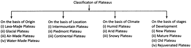
Classification of Plateaus on the basis of stages of development:
The development of plateaus is the result of a long period of time. Considering the time of their origin to the present as a basis, the plateaus are classified into the following parts:
- New Plateau
- Mature Plateau
- Old Plateau
- Rejuvenated Plateau
1. New Plateau:
These plateaus are separated from the surrounding plain by the an acute scarp. The rivers flowing on them make a deep valley. The river on the Kolo Plateau has built a deep canyon. The relief in these plateaus is so extensive that it separates easily into the plains.
2. Mature Plateau:
In these plateaus with rough and uneven terrain, the caves and ridges are of steep slope. Their edges look like terrace, as the Plateau of Appalachian. In these plateaus, the walls are perpendicular and the rocky terraces are formed. Broad peaks, platforms and gradines are also found in these.
3. Old Plateau:
The relief of plateau generally transforms into the plain, like Ranchi Plateau. In these plateaus, the rivers flow through shallow valleys. Generally small hills and dome on the surface are found in the form of Monadnock.
4. Rejuvenated Plateau:
The plateaus which attained the old stage are re – elevated due to the internal movements. Erosion re – starts on these plateaus. Its main example is Plateau of Missouri in the United States of America. Maisa, butte and broad platforms are found in these types of plateaus. Plateau of Ranchi in India is also such kind of plateau.
Question 3.
Explain the concept of Land form Development.
Answer:
Continent and ocean are the largest land forms on the earth’s surface. Mountain, plateau and plain are the land forms of the Second Order; and the innumerable land forms formed on them by the external forces are the land forms of the Third Order. None of these land forms are permanent on the earth’s surface.
As a land form develops by endogenetic forces, the process of its destruction begins by exogenetic forces. Tethys Sea was once there, where the Himalayan Mountains stand today. Mountains on getting eroded, transform into the form of plateaus and plains; and the plains, on getting submerged, transform into the form of oceans.
In this way, the cycle of the development of land forms keeps moving continuously. There is enough complexity in the development of land forms. All continents and oceans are made by small and large 20 Tectonic Plates. With the movement of these tectonic plates, tectonic actions take place on their edges, which develop different types of land forms.
The concept of Tectonic Plates has helped in the explanation of occurrences like mountainization, earthquake, volcano and continental drift. In the same way, the concepts of Geomorphic Cycle and Erosion Cycle have paved the way for the understanding of processes related to the development of innumerable land forms of the Third Order.