Rajasthan Board RBSE Class 12 Geography Chapter 10 World: Transport and Network
RBSE Class 12 Geography Chapter 10 Text Book Questions
RBSE Class 12 Geography Chapter 10 Multiple Choice Questions
Question 1.
Physical medium of carrying objects or persons from one place to another place is known as:
(a) Migration
(b) Transportation
(c) Communication
(d) All these
Answer:
(b) Transportation
Question 2.
Which of these countries has the highest road length in the world?
(a) India
(b) USA
(c) Japan
(d) China
Answer:
(b) USA
Question 3.
The highway linking St. John’s city to Vancouver is:
(a) Pan – American highway
(b) Trans Canadian highway
(c) Alaska highway
(d) Stuart highway
Answer:
(b) Trans Canadian highway
Question 4.
Longest National Highway of India is:
(a) N.H. 7
(b)N. H. 8
(c) N. H. 15
(d) N. H. 27
Answer:
(a) N.H. 7
Question 5.
How many metros are included in Golden Quadrilateral plan?
(a) Five
(b) Two
(c) Four
(d) Seven
Answer:
(c) Four
Question 6.
In which country was the first train started in the world?
(a) England
(b) India
(c) America
(d) China
Answer:
(a) England
Question 7.
The Euro Tunnel Channel connects:
(a) England to Paris
(b) London to Paris
(c) Auckland to Paris
(d) Europe to English Channel
Answer:
(b) London to Paris
Question 8.
Which of the following is the longest railways of the world?
(a) Canadian Pacific
(b) Northern Transcontinental
(c) Trans Siberian
(d) Cape Cairo
Answer:
(c) Trans Siberian
Question 9.
Which of the following is the busiest sea waterway of the world?
(a) Mediterranean Sea and Indian ocean
(b) Southern Atlantic Ocean
(c) Pacific Ocean
(d) Northern Atlantic Ocean
Answer:
(d) Northern Atlantic Ocean
Question 10.
On which canal is Tri – system built:
(a) Suez Canal
(b) Panama Canal
(c) Soo Canal
(d) Rhine Canal
Answer:
(b) Panama Canal
Question 11.
How-many types of airways are there in the world?
(a) Five
(b) Ten
(c) Six
(d) Fifteen
Answer:
(c) Six
Question 12.
Which of the following is not included in public communication modes?
(a) Radio
(b) Television
(c) Internet
(d) GPS
Answer:
(c) Internet
RBSE Class 12 Geography Chapter 10 Very Short Answer Type Questions
Question 13.
What is transport?
Answer:
Generally, transport or transportation is the movement of humans, animals and goods from one place to another place by various modes of transportation.
Question 14.
Which country has the highest road length in the world?
Answer:
The United States of America has the highest road length in the world.
Question 15.
Which of the two cities does Trans-Canadian Highway connect?
Answer:
Trans – Canadian Highway connects St. John’s city of Newfoundland to Vancouver city of western coast in British Columbia.
Question 16.
What items are transported through pipeline?
Answer:
Goods like crude – oil, refined petroleum products, natural gas, water and milk are transported through pipelines.
Question 17.
What is communication?
Answer:
Communication is the act of conveying intended meanings from one entity or group to another through the use of mutually understood sighn and semantic rules.
Question 18.
What is internet?
Answer:
The internet, sometimes called simply “The Net”, is a global system of interconnected computer networks that uses internet protocol site to link devices worldwide.
RBSE Class 12 Geography Chapter 10 Short Answer Type Questions
Question 19.
Write a note on internal waterways of the world.
Answer:
Internal waterway goes through rivers and lakes located in continental or terrestrial areas. The rivers or lakes with sufficient water, are suitable for this purpose. The major waterways of the world are:
1. Internal Waterways of Europe:
The low – lying Volga river falling in the north flowing Rhine, Seine and Poe rivers, South flowing Danube, Don, Dniester and Dniester rivers and Caspian Sea are used for internal water transport.
2. Internal Waterways of North America:
Besides the Great Lakes located between USA and Canada, Superior, Michigan, Huron and Erie lakes, and rivers Mississippi, Missouri and Ohio are used as internal waterways along with Saskatchewan, Mackenzie and Ottawa rivers in Canada.
3. Internal Waterways of Asia:
In China rivers Hwang-Ho and Yang-tse, in south east Asia rivers like Ganga, Erawadi, Minam, Sikyang are used as internal waterways.
4. Internal Waterways of South America:
Besides the large river Amazon in North Brazil and its Tributaries, Parana, Paraguay and Plata rivers also help in water transportation.
5. Internal Waterways of Africa:
Big rivers like Nile, Congo, Niger are used in inland waterways Navigation in Africa.
6. In Australia, from the mouth of Murray and Darling rivers upto 1500 km interior, help in water transport.
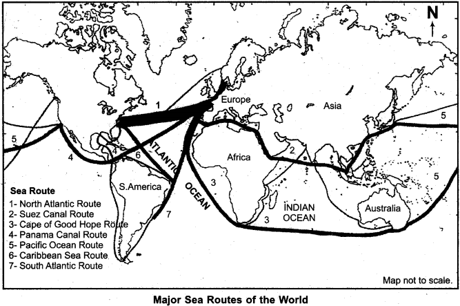
Question 20.
Name major oceanic routes of the world.
Answer:
Major oceanic routes of the world are:
- North Atlantic sea route.
- Mediterranean Sea and Indian Ocean route.
- The Cape of Good Hope route.
- Caribbean Sea route.
- Southern Atlantic route.
- Pacific Ocean route.
- Suez Canal route.
- The Panama Canal route.
Question 21.
Write a comment on highways of the world.
Answer:
Highways are metalled roads connecting distant places. They are constructed in a manner for unobstructed vehicular movement. Major highways of the world are:
1. Pan – American Highway:
This is the longest highway in the world, which connects the countries of South America to Central America, Mexico and the United States of America’ This highway starts from the north-west Alaska and ends in Brasilia Metro city of Brazil.
2. Trans – Canadian Highway:
This highway connects St. John’s city of Newfound – land province to Vancouver city on the west coast in British Columbia.
3. Alaska Highway:
This highway connects Edmonton town of Canada to Anchorage city of Alaska.
4. Stuart Highway:
This highway connects Biratum located in Northern Australia to Unadata City, Ideated in South Australia.
Other Highways:
- Moscow – Vladivostok highway in Russia.
- Highway situated on Vietnam border in China, which connects Shanxi to Shanghai and Guanghou (in the South) to Beijing (in the north).
- In India, the highway runs across Varanasi to Kanyakumari and the Golden Quadrilateral Corridor Scheme (joins New Delhi – Mumbai – Bangaluru – Chennai – Hyderabad and Kolkata metros) joins Kashmir to Kanyakumari and Porbandar to Silchar.
Question 22.
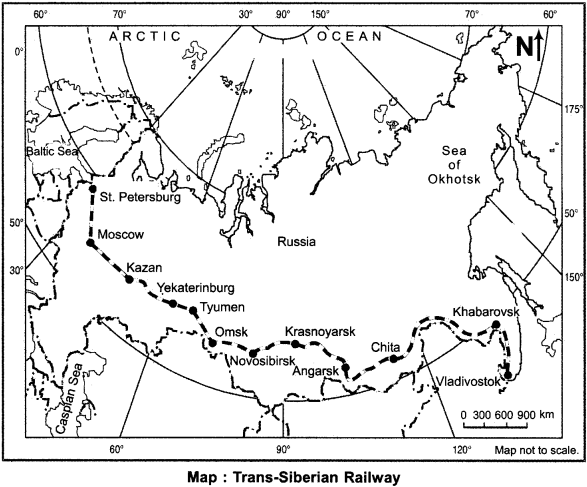
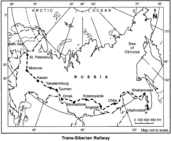
Describe Tran – Siberian railways.
Answer:
Trans – Siberians is the longest railway in the world. It is located in the western part of Russia, from Leningrad (Saint Peters – burg) town on the Baltic Sea coast, to the east of Russia on the shores of the Pacific Ocean at Bladivostok and is 9560 km long. Its construction was started in 1891. This railway was ready in 1905 and upto 1945 there was no obstruction for its use.
This railway goes to Russia’s capital Moscow, along with Tula, Kazan, Tyumen, Omsk, Novosibirsk, Chita, Khabarovsk cities. Specially, the development of Siberia has become possible by the construction of this railway. The commercial and economic importance of this railway has much increased. It was doubled in the year 1945. Since, this railway goes across Siberia, it is known as Trans – Siberian Railway.
Question 23.
Describe Panama canal route.
Answer:
Panama canal route connects the Atlantic ocean in the east to the Pacific Ocean in the west. The Panama Canal was inaugaurated on August 15, 1914. Though the idea of construction of canal was initiated in 16th century. Yet it took so long period to implement it. The main reason for this delay was that the land of Panama corridor was so hilly that it was very difficult to overcome this obstacle.
The average length, width, depth of the canal is 82 km 90 meter and 12 meter. Sea part of the canal is 26 meter high from the sea level. There are three locks in it:
- Lock near the Atlantic Coast (gatun locks).
- Padromiguel lock in the middle.
- Miraflores lock near the Pacific Coast.
Importance of panama canal are:
1. By passing through this canal, the distance between New York and San Francisco is reduced by 13000 km as compared to the Cape Horn distance.
2. The distance between San Francisco and New Orleans through Panama Canal is 9000 km and distance between New York to Sydeny is reduced by 6500 km and the distance from Valparaiso (Chile) to New York is reduced by almost 6000 km.
Question 24.
Mention the characteristics of the Suez Canal route.
Answer:
The Suez Canal is the largest artificial waterway designed to join the Mediterranean Sea and the Red Sea in Egypt. It was inaugurated in 1869. It connects Port Sayeed situated on the Mediterranean coast in Egypt to Port Suez situated on the Red Sea coast.
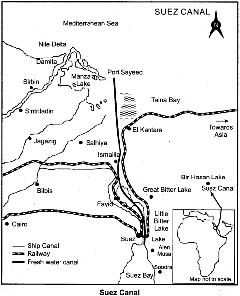
Characteristics of Suez Canal route:
- The length of Suez Canal is 162 km with average width and depth 60 meter and 10 meter respectively.
- It was nationalised by Egyptian’government in 1956.
- An average of 100 vessels cross the canal every day.
- It offers Europe a new entrance route in the Indian Ocean.
- The distance of direct sea route between Liverpool and Colombo of about 1600 km is saved due to this Suez Canal Route.
- With its construction, the trade volume between Eastern countries and Europe and Western countries has increased largely and goods have been traded cheaply. Prices have much fallen down.
- Naval ships primarily pass through this route from North America and Europe to various Asian countries.
Question 25.
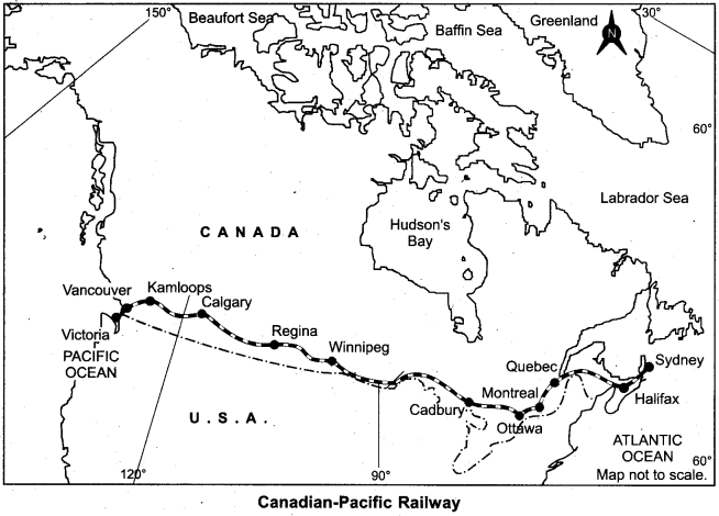
Write a note of the Canadian Pacific railway.
Answer:
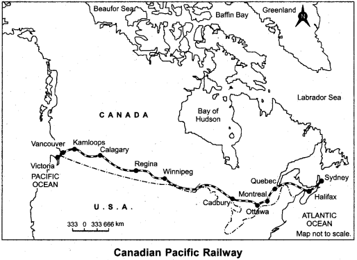
It is the most important railway in Canada. It is parallel to the boundaries of the adjacent state and approximately 750 km long along the Atlantic Coast from the Pacific Ocean. It was constructed in 1886, initially as part of an agreement to make British Columbia on the West Coast join the Federation of States of Quebec-Montreal Industrial Business centre.
Question 26.
Describe the modes of communication.
Answer:
The imparting or exchanging of information through speaking, writing or using any other medium is called communication. There are two main categories of communication.
1. Personal modes of communication:
Letter-writing, telephones, mobile phones, fax, E-mail, Internet, facebook, twitter, Whatsapp are some of the examples of personal modes of communication.
2. Public modes of communication:
Radio, television, cinema, G.P. S., G. I. S., sattelite, newspapers, magazine, books, public meeting, conferences, etc. are public modes.
RBSE Class 12 Geography Chapter 10 Long Answer Type Questions
Question 27.
Describe any two major rail routes of the world.
Answer:
There are many rail routes in the world out of which two major rail routes are given below:
- Northern Inter – Continental Railways.
- Middle Inter – Continental Railways.
1. Northern Inter – Continental Railways:
This railways starts from New York city on the coast of Atlantic Ocean in the northern part of the adjacent state. And the shilling occurs when the Pacific Ocean coastal part reaches Seattle. The length of this railways is about 6100 km. It is the longest and the most important railways in United States. This route passes through the city of Pittsburg which has the global fame for its iron – steel industry.
Onwards it leads to the huge Chicago – Gary Industrial city of the south shore of Lake Michigan and to north-west it leads to the city of Bismarck located in the Prairie region of Saint Paul. In contrast to many European countries, these railways are used more for long distance bulky freight like ores, grains, timber and machinery than for passengers.
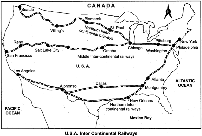
2. Middle Intercontinental Railways:
This railways connects New York city to the Pacific coastal famous port of San-Francisco. It is as valuable and important for America as Northern Intercontinental railways is for Chicago. This railways goes parallel to northern inter continental railways from Chicago. Here it separates and reaches Omaha City on the coast of the Missouri river. It also covers the green valley of Cheni City, Salt Lake City via Rocky mountains in the west. From here, the green valley of California begins. This railway terminates by going to San Francisco city of the Pacific Ocean.
Question 28.
Highlight the commercial importance of Suez and Panama lake routes.
Answer:
Commercial Importance of Suez Canal:
Commercial importance of Suez Canal is described as given below:
- Suez Canal offers ships the shortest routes between Europe and Asia. Using this route, the distance between Liverpool and Colombo of about 1600 km is saved in comparison to the Cape of Good Hope route.
- This canal provides a new route in Indian Ocean to Europe.
- The business relations between Europe and Asia have become much stronger due to this route.
- This route provides cheap, speedy and unobstructed transportation that reduces the price of goods.
- This canal route passes through the most densely populated areas and provides transportation facilities to large populations.
- The western countries export machinery, clothing, medicines, chemicals, etc. to eastern countries and import raw materials like jute, wheat, silk, tea, coconut, wool, meat, tin, rubber, etc.
- There are several ports situated on this route.
- This route is situated at the center of three continents of Europe, Africa, and Asia, so this route provides an easy and comfortable transportation facility to these continents.
Commercial Importance of Panama Canal:
- Panama Canal is situated in Panama in central America. The Panama Canal was built to shorten the distance between Atlantic and Pacific Ocean.
- This canal has reduced the distance between San Francisco and New Orleans by 9000 1 km, and also between New York and Valparaiso (Chile) by about 6500 1 cm.
- The USA gets the most benefits from this route. It has reduced the ditance between the western and north – east America and other countries like Australia, New Zealand and Japan.
- This canal has made a rapid increase in trade and business among the coastal countries situated on Atlantic and Pacific Ocean.
- Although in comparison of Suez Canal, its business importance is less, yet it has a great importance in the South American economy.
- Via this canal, petrol from California, soda and copper from Chile, tea and silk from China, meat, butter, cheese and leather from New Zealand, readymade products, medicines, clothes, machinery, etc. are transported to the continental countries.
Question 29.
Describe the importance of North Atlantic waterways.
Answer:
North.Atlantic waterways is the busiest oceanic route of the world. It is very important for trade and business:
- This most busiest route connects west European countries and North America and Canada.
- One – fourth international trade of the world is connected to this route.
- 25 per cent marine vessels of the world use this route and make it the busiest waterways.
- The developed ports with modern facilities are situated at the two shores of this waterways.
- 30 out 50 major ports of the world lie on this route.
Question 30.
Describe the importance of airways in the world and describe any one type of airway.
Answer:
An airways or air route is a defined corridor that connects one specified location to another location at a specified altitude, along which an aircraft that meets the requirements of the airways may be flown.
Types of Airways:
There are six types of airways:
- Trans – Continental Global Airways.
- Continental Airways.
- National Airways.
- Regional Airways.
- Local Airways.
- The Airways for the various Heads of states, soldiers, battlefronts, diplomats, etc.
Importance of Airways in the World:
Importance of airways can be explained as:
- Airways is the most rapid but most expensive means of transportation.
- Due to being the most expensive, only light, precious and perishable goods are sent
through aircraft. - In the hilly or flooded or other inaccessible areas where water transport or land transportation cannot be developed, passengers and goods can be sent by small planes or helicopters.
- Air transport is the most useful for relief work in natural disasters such as flood, earthquake, and war etc.
- When roads are blocked in the mountains due to heavy snow fall or landslides, the only option for rescue or transportation is airways.
- In the desert regions, airways reach for rescue or other purposes.
Trans – Continental Global Airways:
Airways which are used to travel from the regions of one continent to another continent are called transcontinental global airways. These types of airways have the longest air route. For example,
- New York – London – Paris – Rome – Cairo – Delhi – Mumbai – Kolkata – Hong Kong – Tokyo airway.
- New York – San Francisco – Honolulu – Hong Kong – Adelaide – Perth airway.
RBSE Class 12 Geography Chapter 10 Additional Questions with Answers
RBSE Class 12 Geography Chapter 10 Multiple Choice Questions
Question 1.
Two ends of Pan American highway are:
(a) Alaska and Brazil
(b) Alaska and Chile
(c) Alaska and Argentina
(d) Canada and Mexico
Answer:
(a) Alaska and Brazil
Question 2.
The country of the world which has the most length of road express highways in it:
(a) China
(b) France
(c) United States of America
(d) Japan
Answer:
(c) United States of America
Question 3.
Which of these countries has the highest density of highways?
(a) United States of America
(b) China
(c) Argentina
(d) Canada
Answer:
(a) United States of America
Question 4.
Highways in which of the following countries criss – cross while joining the major cities?
(a) USA
(b) China
(c) Brazil
(d) Canada
Answer:
(b) China
Question 5.
The country that has the highest length of roads for every square kilometer:
(a) India
(b) Japan
(c) United States of America
(d) France
Answer:
(c) United States of America
Question 6.
The continent where the most dense railways system of the world is found:
(a) Asia
(b) Africa
(c) Europe
(d) North America
Answer:
(c) Europe
Question 7.
Which of the following continents stands first in railways development:
(a) South America
(b) Europe
(c) Asia
(d) North America
Answer:
(d) North America
Question 8.
The Trans – Siberian Railways goes from:
(a) Bladivostok to Leningrad
(b) Cairo to Capetown
(c) Tokyo to Yokohama
(d) Chicago to New York
Answer:
(a) Bladivostok to Leningrad
Question 9.
The Orient Express railways runs between:
(a) Paris to Berlin
(b) Paris to Madrid
(c) Paris to Instambul
(d) Moscow to Los Angeles
Answer:
(c) Paris to Instambul
Question 10.
The city that does not lie on Trans – Siberian railways is:
(a) Vladivostok
(b) Leningrad
(c) Omaha
(d) Chita
Answer:
(c) Omaha
Question 11.
Canadian Pacific railways runs:
(a) Between Edmonton to Halifax
(b) Between Montreal to Vancouver
(c) Between Ottawa to Prince Rupert
(d) Between Halifax to Vancouver
Answer:
(d) Between Halifax to Vancouver
Question 12.
Australian Intercontinental railways run between:
(a) Sydney to Perth
(b) Perth to Melbourne
(c) Kalgoorlie to Melbourne
(d) Port Augusta to Perth
Answer:
(a) Sydney to Perth
Question 13.
The busiest transport river is:
(a) Volga
(b) Seine
(c) Rhine
(d) Danube
Answer:
(c) Rhine
Question 14.
The most important international internal water route of the world is:
(a) Danube
(b) Rhine
(c) Volga
(d) Yangtze Kiang
Answer:
(b) Rhine
Question 15.
The busiest sea trade route in the world is:
(a) Northern Pacific route
(b) Northern Atlantic route
(c) Southern Atlantic route
(d) Southern Pacific route
Answer:
(b) Northern Atlantic route
Question 16.
Statement (A): Northern oceanic water route is the most important oceanic route in the world.
Reason (R): Northern Atlantic oceanic route connects the developing countries to developed countries.
Choose the right answer from the following:
(a) Statement A and its reason R both are true and R explains A properly.
(b) Statement A and reason R are both true but R does not explain A properly.
(c) A is true but R is false.
(d) A is false but R is true.
Answer:
(c) A is true but R is false.
Question 17.
Which of the following is called the Grand Trunk Route?
(a) Northern Atlantic Oceanic route
(b) Mediterranean Sea and Indian Ocean waterway
(c) Southern Atlantic Ocean route
(d) Northern Pacific Ocean route
Answer:
(a) Northern Atlantic Oceanic route
Question 18.
The Suez Canal connects:
(a) Red Sea and Dead Sea
(b) Mediterranean Sea and Atlantic Ocean
(c) Gulf of Aqaba and Mediterranean Sea
(d) Red Sea and Mediterranean Sea
Answer:
(d) Red Sea and Mediterranean Sea
Question 19.
Panama Canal connects Gulf of Panama to:
(a) Derian Gulf
(b) Gulf of Honduras
(c) Compenche Gulf
(d) Gulf of Tehuantepec
Answer:
(a) Derian Gulf
Question 20.
Atlantic and Pacific oceans are connected by:
(a) Kiel Canal
(b) Suez Canal
(c) Panama Canal
(d) Suez Canal
Answer:
(c) Panama Canal
Question 21.
Suitable mode of transportation for liquids like water, petroleum, natural gas is:
(a) Pipeline
(b) Railways
(c) Aircraft
(d) All these
Answer:
(a) Pipeline
Question 22.
‘Big Inch’ pipeline transports:
(a) Milk
(b) Afghanistan – Pakistan
(c)Lified petroleum gas
(d) Pertroleum
Answer:
(c)Lified petroleum gas
Question 23.
TAPI Project is related to:
(a) Turkmenistan – lndia
(b) Water
(c) India – Turkmenistan
(d) Afghanistan, Pakistan and India
Answer:
(d) Afghanistan, Pakistan and India
Match the Following
Question 1.
Match the options given in column A with correct options given in column B:
| Column A (Rail Line) | Column B (Distance) |
| (i) Broad guage | (a) 1 m |
| (ii) Meter gauge | (b) 0.762 m |
| (iii) Narrow gauge | (c) 0.610 m |
| (iv) Lift gauge | (iv) Lift gauge |
Answer:
(i) (d), (ii) (a), (iii) (b), (iv) (c).
RBSE Class 12 Geography Chapter 10 Very Short Answer Type Questions
Question 1.
What do you understand by the term circulation?
Answer:
The combination of transportation and communication is known as circulation.
Question 2.
What are the modes of transportation in the modern age?
Or
What are the modes of transport of the world?
Answer:
The modes of transport of the world are:
- Land transport
- Water transport
- Air transport
- Pipeline transport
Question 3.
What is meant by transport network?
Answer:
A transport network or transportation network is a realization of a special network describing a structure which permits either vehicular movement or flow of some commodity.
Question 4.
Into how many parts land transportation can be divided?
Answer:
Land transportation can be divided into two parts – roadways and railways.
Question 5.
Which is more beneficial mode than railways for small distances.
Answer:
For small distance roadways are more beneficial than railways.
Question 6.
What is the road density?
Answer:
Road density is the ratio of the length of total road network of country to the land area of country. The road network includes all roads in the country. Motorways, highways, main or national roads, secondary or regional roads and other urban and rural roads. Normally the network of roads found in per 100 sq. km areas are called road density.
Question 7.
Which continent of the world has the highest road density and the most number of vehicles?
Answer:
North American continent.
Question 8.
What is highway?
Answer:
A highway is a main road, especially one that connects towns or cities on which traffic runs quite smoothly without any obstruction.
Question 9.
Which two cities does Alaska Highway connect?
Answer:
The Alaska Highway connects the town of Edmonton in Canada to Anchorage city, Alaska.
Question 10.
Write the names of the initial station and the end point of Stuart highway.
Answer:
The Stuart Highway connects the city of Biratum in Northern Australia to Alice Springs located at Unadatto in Southern Australia.
Question 11.
Name the new highway which was built by China in the Tibet region.
Answer:
Chenghu – Lhasa highway was built by China in Tibet.
Question 12.
At what position does India stand with regard to length of metalled roads?
Answer:
With regard to length of metalled roads, India stands at the third position in the world.
Question 13.
How many highways are there in India?
Answer:
There are a total of 230 highways in India.
Question 14.
Name the cities, which would be connected to one another under the project of Golden Quadrilateral Corridor Scheme.
Answer:
The cities of New Delhi, Mumbai, Benguluru, Chennai, Kolkata and Hyderabad would be connected under the project of Golden Quadrilateral Corridor Scheme.
Question 15.
What are the Border line roads?
Answer:
The roads which are built along the International boundaries or borders are called Borderline roads. These types of roads play important role in connecting the distant places to major cities as well as the capital of the country.
Question 16.
Between which two points did the first rail (train) run in the world?
Answer:
The first train of the world was run between Archton and Darlington in England.
Question 17.
When and Where did the first train run in India?
Answer:
The first train in India ran between Mumbai to Thane in 1853.
Question 18.
Classify the rail – lines on the basis of their breadth.
Answer:
On the basis of breadth, the rail – lines are divided into four categories:
- Broad guage (1.67 m).
- Meter guage (1.0 m).
- Lift – guage (0.610 m).
- Narrow – guage (0.762 m).
Question 19.
In which country is standard guage (1.44 m) of railway used?
Answer:
Standard guage of railways is used in Britain.
Question 20.
Which country of the world has the highest railways density?
Answer:
The highest railways density is found in Belgium (1 km per 6.5 sq. lcm area), a European country.
Question 21.
Name the country which has a record length of railways in the world.
Answer:
United States of America has a record length of railways. Total length of rail lines here is 2.27 lakh km.
Question 22.
What is the name of the railways which passes through a continent and connects its two ends?
Answer:
The railways that passes through a continent and connects its two ends is transcontinental railways.
Question 23.
Name the two dense regions of South America where railways have a great value.
Answer:
Pampas grassland of Argentina and the coffee producing region of Brazil are the two regions where
railways are most important.
Question 24.
Name the countries where the most dense railways is found in Asia.
Answer:
Japan, China and India have the most dense railways in Asia.
Question 25.
What is the length of Trans – Siberian railways?
Answer:
The length of Trans-Siberian railways is 9560 km.
Question 26.
Write one characteristic of Trans-Siberian railways?
Answer:
Trans – Siberian railways can run without any obstruction between both the railways and the electricified cross – continental railways in the double path.
Question 27.
Name the major cities from which Trans Siberian railways passes through.
Answer:
The Trans – Siberian railways passes through the cities of St. Petersburg, Moscow, Kazan, Yakaterin bury, Tyumin, Omsk, Novosibirsk, Krasnoyarsk, Chita, Angarsk, Khabarovsk and Vladivostok.
Question 28.
Name the end stations of the longest railway route of the world.
Answer:
The Trans – Siberian/Railways is the longest railways route of the world. Its eastern station is Vladivostok and western station is St. Petersburg.
Question 29.
Name any four Trans-continental railways routes.
Answer:
Trans – Siberian Railways, Trans – Canadian Railways, Orient Express Railways and Australian Trans – Continental Railways are the four main trans – continental railways.
Question 30.
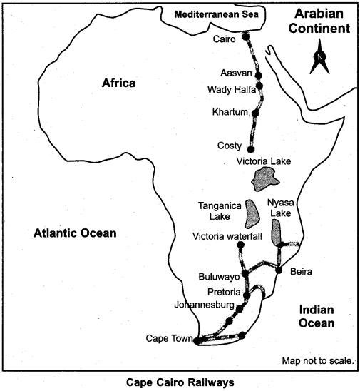
Which cities would be connected through Cape Cairo railways?
Answer:
Cairo would be connected to Capetown through Cape – Cairo Railways.
Question 31.
What is the length of Cape – Cairo Railways?
Answer:
The length of Cape – Cairo Railways is 14000 km.
Question 32.
Name the mode of transportation which is the cheapest to carry heavy goods through long distances between the continents.
Answer:
Water transportation is the cheapest to carry heavy goods through long distances between the continents.
Question 33.
Name any two internal waterways of Europe.
Answer:
Name of two major waterways in Europe are:
- Rhine waterway.
- Danube waterway.
Question 34.
Name the most important internal waterways in Germany.
Answer:
The most important internal waterways in Germany is Rhine.
Question 35.
Where is Rhine river navigable for boating?
Answer:
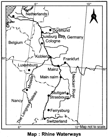
The river Rhine is usable for boating from its origin Dortmand (Netherland) to its end point in Switzerland (Bessie). The distance between Dortmand to Switzerland is 700 km.
Question 36.
Where is Volga waterways situated? Also mention its length.
Answer:
Volga waterways is situated in Russia, and its total length is 11200 km.
Question 37.
Name any two major oceanic routes of the world?
Answer:
The two major oceanic routes of the world are:
- Northern Atlantic Oceanic route.
- Mediterranean and Indian oceanic route.
Question 38.
Which of the major lakes of North America provides the facilities of internal water transport?
Answer:
Lake Superior, Michigan, Huron and Erie provide the facilities of internal water transport in North America.
Question 39.
On which oceanic way is Honolulu port situated?
Answer:
Honolulu port is situated on the Southern Pacific sea route. It is an important port.
Question 40
Why is Northern Atlantic Oceanic route called major trunk waterway?
Answer:
One – fourth of world trade is operated through Northern Atlantic Oceanic route. As it is the busiest route, it is also called grand trunk waterways.
Question 41.
From where and upto which place does Panama canal reach?
Answer:
The Panama Canal proceeds from the city of Panama situated on the Pacific Coast to the city of Colon, situated on the shore of Atlantic Ocean Coast.
Question 42.
Where and why was Suez canal built?
Answer:
Suez canal was built in 1869 to connect the Mediterranean Sea and the Red Sea between Port Sayeed in the South and Port Suez in the south in Egypt.
Question 43.
Name the waterway which has significantly shortened the distance between India and Europe.
Answer:
Suez Canal has shortened the distance between India and Europe.
Question 44.
What is the most speedy mode of transportation?
Answer:
The most speedy mode of transport is air transportation.
Question 45.
Why is modern age called the “air age” ?
Answer:
Since the middle of 20th century, the operation and use of air transport has increased rapidly, that’s why modern age is called the Air Age.
Question 46.
Name any two continental air routes.
Answer:
The famous continental air routes are:
- New York – Chicago – Montreal route
- Delhi – Kolkata – Hong Kong – Tokyo air route.
Question 47.
Why are pipelines used for the transport of liquid and gas-based goods such as petroleum and LPG?
Answer:
As petroleum and natural gas are fluid and flowable so they can easily be sent through pipelines from one place to another place.
Question 48.
Which is the longest proposed pipeline in the world?
Answer:
The proposed international pipeline from Iran – Via – Pakistan – India for petroleum and natural gas is the longest in the world.
Question 49.
What is ‘Big Inch’?
Answer:
‘Big Inch’ is a famous pipeline which carries petroleum from Gulf of Mexico to north – eastern provinces of United States of America.
Question 50.
Name the public means of communication.
Answer:
Some public means of communication are radio, television, cinema, GPS, newspapers, magazines, satellite, conferences, meetings, etc.
Question 51.
Name the individual means of communication.
Answer:
The name of individual means of communication are letter, telephones, mobile – phones fax, e-mail, internet, facebook, twitter and whatsapp.
Question 52.
What do you understand by the term ‘satellite communication’?
Answer:
Information and news broadcast through artificial satellites is called satellite communication.
Question 53.
Honolulu is of Oceanic route an important sea port.
Answer:
Honolulu is an important sea port of Southern Pacific Oceanic route.
RBSE Class 12 Geography Chapter 10 Short Answer Type Questions (SA-I)
Question 1.
Define Transportation and explain different types of transportation briefly.
Answer:
Transportation is a movement of goods or persons from one place to another place by physical medium.There are four types of transportation:
1. Land transport:
Land transport includes:
(a) Road transport:
The road is the cheapest means of transportation for shorter distances.
(b) Railways:
Rail transportation is the best to carry heavy goods and passengers to a long distance inside a country.
2. Water transport:
It is the cheapest and the best means of transportation to carry heavy goods outside the country or to other continents.
3. Air transport:
It is suitable to carry light but precious goods. It is more expensive but quite reliable.
4. Pipelines:
Liquid and gas can be transported through pipelines. Water transportation through pipelines is very common.
Question 2.
What is the difference of the quality of roads in developed countries and in developing countries?
Answer:
The developed countries are economically and technically prosperous, therefore, they are able to afford high quality of materials as well the technology to build the roads, also they are capable to bear the cost of maintenance of the roads. So the roads in developed countries are good looking, comfortable and smooth for travelling. On the other hand, roads in developing countries are of inferior quality because they use lower quality of materials and technology to build roads, and their maintenance is also poor.
Question 3.
What is a highway? Write its major characteristics.
Answer:
A highway is a public road or other public way on land which connects distant places and on which means of transportation run quite smoothly.
Characteristics:
- The highways are built so. that the vehicles move without any obstruction.
- For smooth flow of traffic, many lanes are built on them.
- The highways are replete with bridges, flyovers and double vehicle lanes.
- The width of these roads is 80 meters.
- In developed countries, highways are connected to every city and port city.
Question 4.
Give characteristics of highways in North America.
Answer:
- The density of highways in North America is 0.65 km per square km, which is the highest in the world.
- Every place is situated at a maximum distance of 20 km from related highway.
- The Canadian cities of north are connected to Mexico in south.
- In the west, cities situated on the shore of Pacific Coast.are well connected to the cities on Atlantic Coast in the east.
- Trans – Canadian highway, Alaska highway and Pan America highway are the most important highways in North America.
Question 5.
Write the characteristics of Railways in Europe.
Answer:
The main characteristics of European Railways are:
- Latest technology is used in constructing European railways.
- It has double ways and electrification has been done everywhere.
- Metro – railways are found in European railways.
- The rail routes pass through all major cities and industrial areas.
- European railways connect all Metropolitan cities like London, Paris, Brussels, Milan, Berlin, Warsaw, etc. to one another.
- The Euro Tunnel railways connect London to Paris.
Question 6.
Write down a brief note on South American railways.
Answer:
High density of railways is seen in the following two regions of South America:
- Pampas region in Argentina.
- The coffee plantation region in Brazil.
40% of total railways of South America is found in these two regions. After Argentina and Brazil, Chile stands third in railways, which connects internal areas of the country to the regions where mining is done on large scale. These are comparatively smaller and single route rail lines in Peru, Bolivia, Equador, Columbia, and Venezuela. In South America, there is Pan – Continental railways which goes to Valley of Usplata situated at the height of 3900 meter in the Andes mountain range and then connects Buenos Ares in Argentina to Valparaiso.
Question 7.
Name major railways of Africa.
Answer:
Major railways of Africa are Beguela railways (Angola – Katanga), Tanzania railways (Zambia’s copper belt to Dar – e – Salam) which goes via Botswana and Zimbabwe and connects several states to the railways network. There is a blue train route in Africa which goes from Capetown to Pretoria.
Question 8.
What are Trans – Continental railways? Name five major trans-continental railways of the world.
Answer:
Trans – continental railways runs across the continent and links its two ends. These were constructed for economic and political reasons to facilitate long runs in different directions. The major Trans – Continental railways are:
- Trans-Siberian Railways.
- Canadian Pacific Railways.
- Northern United States Intercontinental Railways.
- Southern United States Intercontinental Railways.
- Australian Intercontinental Railways.
Question 9.
Write a short note on Southern Intercontinental Railways of the United States of America.
Answer:
This Railways proceeds from New York to Los Angeles on the Pacific Coast, via New Orleans. This route passes through the middle of the major industrial belt of the United States, which has special significance. The city of Los Angeles is world famous for film production.
Southern intecontinental Railways has extreme significance in United States. This railways is very important for Hollywood film industry. The contribution of southern intercontinental railways in the development of Hollywood film industry is remarkable. In this way, it is the basis of social, economic and industrial development of United States of Aimerica.
Question 10.
Describe the merits of water transportation.
Answer:
The merits of water tranportation are:
- Waterways passes through rivers, lakes, canals and oceans, therefore no special, expenses are spent for the construction of water routes.
- It is the cheapest means of transportation.
- Normally, cheap and heavy goods like coal, iron ore, iron-steel, etc. are carried through waterways.
- The cost of energy used in water tranport is cheaper than that of all other means of transportation.
- The capacity of loading of the ship is greater than the trucks, arrcrafts etc.
- There is no extra burden for maintenance of waterways.
Question 11.
Write a short note on the development of internal waterways of the world.
Answer:
The means of internal waterways are the rivers and lakes found in a country or continental and terrestrial areas. The development of Internal waterways depends on the width, depth, length and the capacity of the navigation of the river or a lake. It also needs sufficient water in the river and lakes in all seasons. So, for the development of internal waterways, we need such rivers and lakes in which:
- There is enough water throughout the year.
- The depth of water is sufficient.
- There is gradual slope at the bottom.
- The lower surface of the river or lake must be free of sediments.
Question 12.
Describe the Rhine waterways briefly.
Answer:
Rhine river waterways is busiest internal water route in the world, therefore Rhine water route has great social, political and industrial importance. The Rhine river flows through Germany and Netherland. The route connects industrial areas of Switzerland, Germany, Belgium and Netherland to the Atlantic Ocean waterway. This river is suitable for boating upto a navigable distance of 700 km. The associate river of Rhine is Ruhr, which flows in the eastern coal-mining areas and finally joins the Rhine.
Question 13.
Why is Rhine waterway the busiest water route of the world? Explain briefly.
Answer:
Main causes of Rhine waterways being the busiest water – route are:
- There are prosperous mining areas near this water route.
- This water route connects the rich industrial areas of Switzerland, Gemany, France, Belgium and Netherlands.
- Due to suitable conditions for navigation, more than 20,000 ships pass through this waterway every year.
- The Rhine has 700 km length for good transportation which is from Switzerland to Rotterdam.
Question 14.
Describe four major characteristics of Suez Canal.
Answer:
The Suez Canal was built in 1869 and the purpose of its construction was to connect the Red Sea to Mediterranean Sea between Port Sayeed in the north and Port Suez in the south. Main characteristics of Suez Canal are:
- This canal provides a new access to Europe through the Indian Ocean.
- This canal is 162 km in length, is 60 meters wide and has an average depth of 10 meters.
- More than 100 ships travel through this canal every day.
- The distance of direct sea route between Liverpool and Colombo saves about 1600 km in comparison to Cape of Good Hope Route.
Question 15.
Describe any four characteristics of the Panama Canal.
Answer:
Panama Canal connects the Atlantic Ocean in the east to the Pacific Ocean in the west. Main characteristics of this canal are:
- The length of this canal is 82 km, width is 90 meters and average depth is 12 meters.
- There are three locking systems entering the canal with a total of 6 blocks.
- By passing through this canal, the distance between Newyork and San – Francisco has been reduced by about 1300 km.
- Panama Canal plays an important role in South American economy.
Question 16.
Explain the importance of air transport in the sphere of transportation.
Answer:
The importance of air transport is due to the following reasons:
- The air transport is the most expensive and the most reliable means of transport.
- It is the most rapid amongst all means of transport.
- Due to its fast speed, it is the most popular means of transport.
- Light, precious and perishable goods are sent through airways.
- The hilly areas, snowy mountains or odd deserts can be approached easily through airways.
- Air transport is the most useful for the relief work in natural disasters like flood, earthquake and war, etc.
- Air transport is most useful in rescue operations.
Question 17.
What do you know about pipeline transport? Explain briefly.
Answer:
Pipelines are the latest means of transportation. Crude oil or petroleum is transported to refineries and refined petroleum products are sent to consumer centres by this means of transportation. In addition, natural gas is also transported by pipelines. A high density of pipelines is found in Europe and middle – east countries. Pipelines are used extensively in transporting liquids and gases such as water, petroleum, and natural gas.
For they have uninterrupted flow, water supply through pipelines is familiar to all. Cooking gas or LPG is supplied through pipelines in many parts of the world. In New Zealand, milk is being supplied through pipelines from dairy farms to processing plants. A dense network of piplines is found between the production regions and the consumption regions of united States of America.
Among these, the most famous is the ‘Big Inch’ pipeline, which supplies oil obtained from the coastal wells of Gulf of Mexico to the north – eastern states. In Europe, western Asia, Russia and India, pipelines are used, to join the oil wells with the refineries and internal markets. The pipline from Turkmenistan, a country in central Asia, has been extended to Iran and some parts of China. After the completion of the proposed Iran – Pakistan – India oil and gas pipeline, it will be the world’s longest pipeline.
Question 18.
Write a short note on satellite communication.
Answer:
The communication through satellite has emerged as a new feature in communication technology since 1970. United States of America and former U.S.S.R pioneered space research. Artificial satellites are now successfully deployed in the earth’s orbit to connect even the remote corners of the world with limits of site verification. The satellites have reduced the unit cost and time of communication and the cost incurred in communication for 500 km is now equal to the cost incurred in satellite communication for 5000 km.
Question 19.
What steps have been taken by India towards the progress of satellite communication?
Answer:
India has made great strides in satellite development. Aryabhatta was launched on 19 April 1975, Bhaskar – I in 1979 and Rohini satellite in 1980. Apple (Arian passenger payload experiment) was launched through Arian rocket in June 1981. It was ISRO’s first indigenous, experimental communication satellite. Bhaskar, and INSAT – I.B have made long distance communication, television and radio very effective. India has launched more than 80 spacecrafts. Due to which India is included among the top five countries which have contributed a lot in the field of satellite communication.
Question 20.
How will the Cyber-space internet be able to conceptualise the actualisation of Global village?
Or
How has the cyber space internet conceptualised the actualisation of Global village.
Answer:
At present, millions of people use internet every day. Cyber space will expand the contemporary economic and social space of human through e – mail, e – commerce, e – learnings and e – governance. Internet, together with fax, television and radio, will be accessible to more and more people cutting across place and time. These are modern communication systems which have made the concept of global village a reality.
Question 21.
How is satellite communication developing into new forms of communication day by day?
Answer:
While technology goes on developing, the restrictions imposed on it from a protective perspective are ending. Use of information and satellite images by private business companies, educational institutions and government is being done to find areas affected by civilian areas such as urban planning, identify hundreds of physical patterns and processes. And the world would look like a small village in reality.
Question 22.
Differentiate between transportation and communication.
Answer:
The main differences between the transportation and communication are:
| Transportation | Communication |
| 1. This is the process of sending people, useful goods etc. from one place to another place. | 1. The process of exchanging information and thoughts is communication. |
| 2. Roads, railways, waterways, airways and pipelines are the means of transportation. | 2. Letter, telephone, mobile, fax, radio, internet etc. are the means of communication. |
RBSE Class 12 Geography Chapter 10 Short Answer Type Questions (SA-II)
Question 1.
Explain the importance of transportation.
Or
How is the transportation useful for human life?
Answer:
Transportation is an important economic activity driven by humans. It is a productive activity by which income is earned in the form of carrying goods and persons from one place to another place. Productive value of transport is obtained in the form of goods freight or passenger charges. The routes for transport which pass through water and air, are called waterways and airways respectively.
Waterways pass through a lake or river or sea. Transportation by water is carried by boat, steamer – ship, vessel etc. Road and rail routes come under the land transport. Under the means of transport on the road, automobiles, horse carriage, etc. from small vehicles to bus, taxi, truck etc. are included. Transportation of consumer goods by train carriage and freight train is included in railways.
The development of the means of transportation has made the world smaller. It has also been helpful in solving the problem of unemployment. The development of transportation in a country represents the economic status of the country. The improvement of economic condition and national income depend on the available means of transport inside the country.
Question 2.
What is the importance of Cape Cairo Railways?
Or
Describe the usefulness of Cape Cairo railways in respect to Africa.
Answer:
Cape Cairo is a proposed intercontinental railways. Under this plan, the city and the port of Cairo located on the northern end of the Nile river in Egypt in the north-east of Africa are planned to be connected by railways to Capetown at the southern end of south Africa. This route will be approximately 14000 km long.
This railways proceeds through Zimbabwe’s city Bullvayo in the south to Pretoria the capital of South Africa and goes to Capetown, through the well-known town of Johannesburg and Kimberley (gold mines). Due to dense forests and high downhill areas, the traffic in this port is completely undeveloped. Upon completion of the proposed Cape Cairo Railways, African territories from north to south will have mutual relations and this will help in their economic development.
Question 3.
Explain the Mediterranean Sea and Indian Ocean waterways.
Or
Give the importance of Mediterranean Sea and Indian Ocean waterway.
Answer:
This is the longest commercial water route in the world. It goes through the middle part of the world and also serves the largest ports of the world and maximum population. This waterways serves about 75% of the world’s population. This water – route passes through the heart of the old world. It connects industrial countries of western Europe to the Mediterranean Sea, the Red Sea and the Indian Ocean to East Africa, South Asia and Australia.
New Zealand’s economy is commercial agriculture and animal husbandry – based. Before the construction of the Suez Canal, the sea route through Cape of Good Hope connecting Liverpool and Colombo was 6,400 km longer than the Suez canal route. The volume of trade and traffic between East and West Africa is on an increase due to the development of rich natural resources such as gold, diamond, copper, tin, groundnut oil, palm oil, coffee and fruits. Sayeed, Aden, Mumbai, Kochi, Colombo, Adelaide, etc. ports are situated on this water route.
Question 4.
How many types of Air routes are there in the world?
Answer:
There are mainly six types of air routes in the world:
1. Trans – continental Global Airways:
It is the longest route to travel.
- New York – London, Paris, Rome, Cairo, Delhi, Mumbai – IColkata – Hong Kong, Tokyo, Airways.
- New York – San Francisco – Honolulu – Hong Kong – Adelaide – Perth crosses the Pacific Ocean.
2. Continental Airways:
Air travel between different countries of the same continent like:
- New – York – Chicago – Montreal Route.
- London – Paris – Frankfurt – Prague – Warsaw route.
- London – Frankfurt – Warsaw – Moscow route.
- Delhi – Kolkata – Hong Kong – Tokyo route.
3. National Airways:
The airways inside the country is known as national airways:
- New York – Chicago, San Francisco route
- Leningrad – Moscow
- Delhi – Kanpur – Patna – Kolkata route.
4. Regional Airways:
Small strips within a state are also used by the aircraft to save time. In developed countries such as USA, the former Soviet Union, Germany, Britain, Japan, Canada, etc., people frequently use air services for saving time. Regional airways have developed in many regions. Nowadays, young generation prefers to travel through air ways in almost all important cities.
5. Local airplane:
Local air trips are often made by helicopters.
6. Army based airways:
Air visits are carried out by various heads, administrative bosses and various trips are operated by different types of aircrafts, helicopters etc. The air travel is comfortable for the soldiers, diplomats and political personalities.
Question 5.
Describe the merits and demerits of road transportation.
Answer:
Merits of Road Transportation:
- Roadways is the cheapest mode of transport for small distance.
- It provides services at your doorstep.
- It plays an important role in increasing trade and commerce.
- Its contribution in development of tourism is remarkable.
Demerits of Road Transportation:
- A large amount of capital is spent on the construction of roads.
- The unpaved roads are the main cause for accidents.
- All roads cannot be used in all seasons.
- The traffic jam is a main and troublesome problem of modern age.
Question 6.
Describe merits and demerits of rail transport.
Answer:
Merits of railways:
- Railways is the most popular means of transport for daily journey.
- It is the most suitable in carrying heavy goods for long distances.
- Railways connects the mining regions to processing plants and factories.
Demerits:
- A large amount of capital is needed to lay rail lines and to make coaches.
- A large quantity of mineral oil is consumed to operate rail engines.
- On single route pattern of railways, loss of life and property often takes place due to accidents.
Question 7.
Describe the merits and demerits of water transport.
Answer:
Merits of water transport:
- There is no need of capital to construct water routes.
- It uses less energy than that of other means of transport.
- It is the cheapest means of transportation.
Demerits of water transport:
- There are great possibilities of calamity due to storms in the sea.
- Accidents of petroleum – carrying vessels cause the sea creatures in danger.
- There is a threat to the reproduction of the sea animals and vegetation due to operating of vessels in the oceans.
Question 8.
Describe the demerits of Air transport.
Answer:
The demerits of air transport are:
- It is the most expensive means of transport.
- Due to its high costs, it is not available for middle class and lower class people.
- Due to bad weather, there is always a possibility of plane crash.
- Technical defects in aircrafts cause accidents.
- In wars, air transport becomes a great danger for human life.
- It causes sound pollution.
Question 9.
Describe the merits of Cyber – Space (Internet).
Answer:
- It is a collection center of all information of the entire world.
- It is used by millions of people.
- It is the latest means of communication.
- All the information and thoughts of the world can be collected quickly and cheaply at one point.
- It is very useful for educational purpose.
- It is very useful for financial purposes in the modern age.
RBSE Class 12 Geography Chapter 10 Essay Type Questions
Question 1.
Describe the Trans – continental railways of the world with diagrams.
Answer:
The main trans – continental railways of the world are:
- Trans – Siberian Railways.
- Canadian Pacific Railways.
- Northern Intercon – tinental Railways.
- Middle Intercontinental Railways.
- Southern Intercontinental Railways.
- Australian Intercontinental Railways.
1. Trans Siberian Railways:
It is the largest railways, located in the western part of Russia. Its length is 9560 km. It can run without any obstruction between both the terminals and the electricified cross – continental rail-line in double path. This railway route crosses Siberia. The main centres of this route are Moscow, Kazan, Yekaterinburg, Tyumen, Omsk, Novosibirsk, Krasnoyarsk, Angarsk, Chita, Khabarovsk and Vladivostok.
2. Canadian Pacific Railways:
It is the most important railways of Canada, which runs parallel to the boundaries of the adjacent state and is approximately 7050 km long along the Atlantic Coast from the Pacific Ocean. It was constructed in 1886, initially as part of an agreement to make British Columbia on the West Coast join the Federation of states.
3. Northern Intercontinental Railways of USA:
This railway line starts from New York city on the coast of Atlantic Ocean in the northern part of the adjacent state. And this railway line passes through Chicago to upto Seattle on Pacific Ocean coastal part. The length of this railways is 6100 Ion. It is the longest and the most important railways in the United States. Pittsburg, St. Paul, Bismarck and Villings are important cities on this route. Food grains, iron – steel, machines, meat, fruits and wood are carried through this railways.
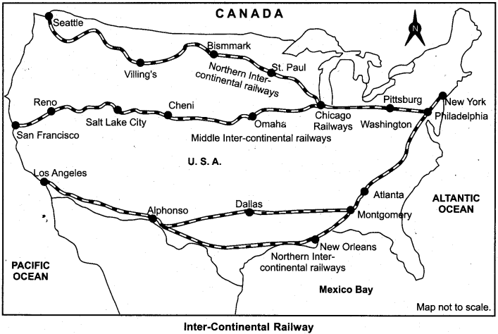
4. Middle Intercontinental Railways:
It connects New York city to the Pacific coastal famous port of San Francisco. This railways just goes with the Northern Intercontinental Railways upto Chicago and there it separates. The main amongst other cities that lie on this route are Omaha, Cheni Salti Lake City and Secramento.
5. Southern Intercontinental Railways:
This railways goes from New York to Los Angles to the Pacific Ocean via New Orleans. This route passes through the middle of the major industrial belt of the United States, which has special significance. The city of Los Angeles is world famous for film production.
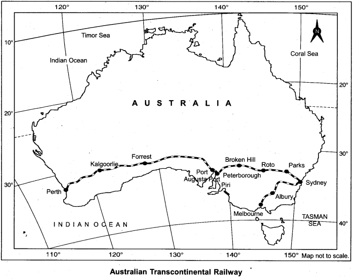
6. Australian Intercontinental Railways:
This railways goes from the southern border of Australian continent from east Sydney to south west to Perth sea port. There is difference in the width of the railroad in many parts of this entire railways.
Question 2.
What is meant by internal waterways? Describe major internal waterways of the world briefly.
Answer:
Internal waterways:
The waterways which go through rivers and lakes located in continental or terrestrial areas are called internal waterways. Main Waterways of the World:
1. Internal waterways of Europe:
In Europe, the Atlantic Ocean in the north west and the rivers falling in the south provide internal waterways to European countries. The low lying towards north-flowing Rhine, Seine and Po rivers, south-flowing Danube, Don, Dnieper and Dniester rivers and Caspian Sea are used for water transport. But amongst all these, the River Rhine flowing through Germany and the Netherlands is most important. The Rhine river waterway is the busiest internal water route of the world.
2. Internal waterways of North America:
The great lakes located between the USA and Canada have full facilities for water transport. This is a major trading route, with the convenience of transporting ships by Lake Superior, Michigan, Huron and Erie to the mouth of the Saint Lawrence river. Mississippi, Missouri and Ohio rivers are also navigable, which connect many industrial cities.
3. Internal waterways in Asia:
In China, navigable facilities are available in rivers Hwangho, Yangtze Kiang and Sikiyang. The river Hwang – Ho is navigable upto 200 km above its Delta in China. The Yangtze Kiang river also allows boats from Shanghai city to Qyikiang and a major part of Sikiyang river is navigable. In India, the Ganges is navigable from Allahabad to Haldia.
4. Inland waterways of South America:
In North Brazil, rivers Aamazon along with its tributaries, upto 3000 km is navigable whereas in South Brazil, Argentina and Uraguay, Parana, Paraguey and river Plata from its Delta to upto 1500 km long the riverways is navigable.
Question 3.
Describe the major oceanic waterways of the world in brief.
Answer:
Major oceanic waterways of the world are given below:
1. North Atlantic oceanic route:
It is the busiest sea waterways of the world. This water route connects west European countries to North America. Almost one quarter of the international trade is carried by this route. 25% of the total vessels are used in this waterways here, and 30 out of 50 major ports are situated on this route.
2. Mediterranean Sea and Indian Ocean waterway:
It goes through the middle part of the world and serves the largest part of the world. It connects industrial countries of western Europe to Mediterranean Sea, and Indian Ocean to East Africa. Ports like port Sayeed, Aden, Mumbai, Kochi, Colombo, Adelaide etc. are situated on this route. The development of rich natural resources like gold, diamond, copper etc. depend on this route.
3. The Cape of Good Hope Route:
This route connects the west Europe and west African countries with Brazil, Argentina and Uruguay in South America. Main ports on this route are Capetown, Port Elizabeth, Adelaide, Melbourne, Sydney etc. It connects the countries of South Africa, Western Europe, Australia and New Zealand.
4. Southern Atlantic Route :
This route passes through East Africa, Asia and Australia. This route connects intensive forest of Amazon Basin, Brazil plateau and Patagonia, Pampos grassland and mineral deposits of South Africa. Major ports on this route are Rio – de – Janerio, Santos, Montevideo, Beunos Aires and Blanca etc.
5. Bay of Caribbean Sea route:
The coastal countries of the Caribbean Sea exchange goods through this route among Columbia, Venezuela, Trinidad, Guyana, Surinam, Western Island Gulf, coastal countries of Mexico and USA. This route connects the Bay of Mexico and the Caribbean Sea coastal ports.
6. Pacific Ocean Route:
This route passes through Honololu (Hawaii Island) port located in the middle of the North Pacific Ocean. The ships of Western and Northern America cross straight to Honolulu by crossing Panama Canal.
There are two branches of this route:
- Northern route which goes to Japan, Philippines and Indonesia.
- The south route goes to Australia and New Zealand.
Question 4.
Name Important airports of the world and locate them on the map.
Answer:
Chief airports on the basis of continents are:
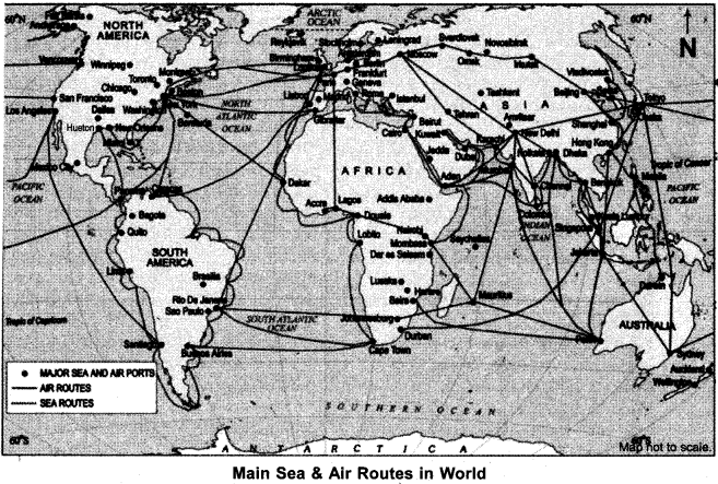
North America:
New York, New Orleans, Chicago, San Francisco, Los Angeles, (United States of America) – Montreal, Ottawa, (Canada) and Mexico city etc.
South America:
Rio – De – Jeneiro, Buenos Aires, Santiago etc.
Europe:
London, Paris, Berlin, Rome, Moscow, etc.
Asia:
Tokyo, Shanghai, Beijing, Bangkok, Singapore, Jakarta, Rangoon, Kolkata, Delhi, Chennai, Karachi, Colombo etc.
Africa:
Capetown, Addis – Ababa, etc.
Australia:
Sydney, Melbourne, Perth, Canberra etc.
Question 5.
Describe major pipelines of the world briefly.
Answer:
Major pipelines of the world are:
1. Big Inch Pipeline:
This pipeline supplies oil from the coastal wells of the Gulf of Mexico to the north-east states in the United States.
2. Tap Pipeline:
This pipeline connects the oil wells near Persion Gulf to a city called Sudan. Its length is 1600 kilometers.
3. Comacon Pipelines:
It is located in the former Soviet Union. Oil from Volga and Ural regions is transported to the countries of Eastern Europe through this pipeline.
4. O.I.L. Pipelines:
The O.I.L. pipelines has been constructed From Naharkatiya of Assom to Barauni oil refinery in Bihar. Its length is 1157 km. It was extended upto Kanpur in 1966.
5. H. V J. Pipe lines:
An important network of another broad pipeline in West India was constructed in Ankleshwar – Koyali, Mumbai High – ICoyali and Hazira – Vijaipur – Jagdishpur. Recently a 1256 km long pipeline was made from Salaya (Gujarat) to .Mathura (U.P.).
6. Tapi project:
The much awaited Turkmenistan-Afganistan-Pakistan-India (Tapi) gas pipeline project was inaugurated on December 3, 2015. in Meri city (Turkmenistan) connected to the historic Silk route. It is likely to be completed by 2019, which will be 1814 km long. It will reach Fazilka (India) via Kandhar (Afghanistan 774 km) and Multan (Pakistan 826 km) from Galkynysh (Turkmenistan) area.
Map Related Questions
Question 1.
Study the given outlined map and answer the questions given below:
1. Name the Railways shown in the map.
2. Name the origin and the end stations of this rail route.
3. Name the two sea ports which are connected by this railway.
4.This railways is of which countries?
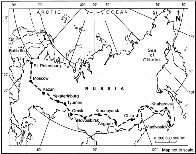
Answer:
- Trans – Syberian Railways.
- Origin station: Saint Petersburg; end station: Vladivostok.
- Baltic Sea and Pacific Ocean.
- Russia.
Question 2.
Study the map given below and answer the related questions.
1. Name the Railways shown in the map.
2. Name the two sea coasts connected by this railways.
3. Name the originating and the terminating stations of this railways.
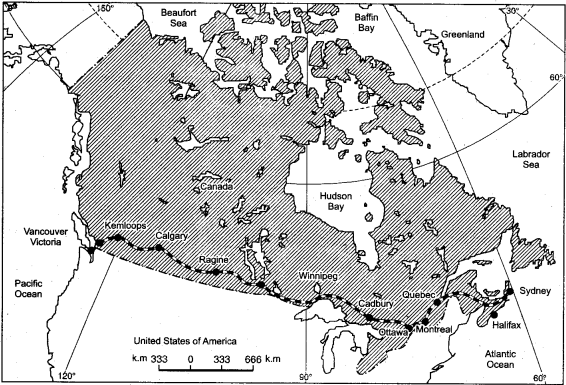
Answer:
- Trans – Canadian railways.
- Pacific Ocean and Atlantic Ocean.
- Originating station – Halifax; Terminating station – Vancouver.
Question 3.
Indicate the following places in the given outlined map.
1. Australian – par – Continental Railways,
2. Mention the originating and terminating stations.
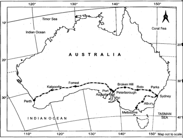
Answer:
Originating station – Perth and Terminating station – Melbourne.
Question 4.
Indicate the following sea ports of the world in the outlined map.
1. Mumbai
2. Melbourne
3. London
4. New York
Answer:
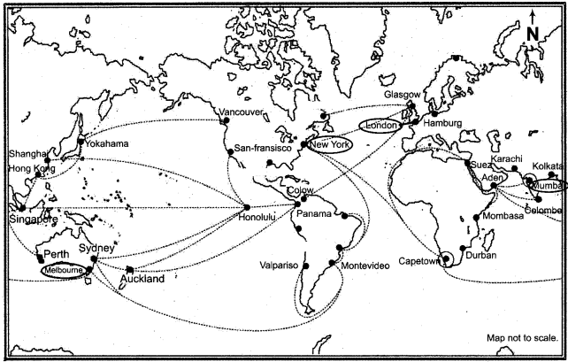
Students should practice in locating other sea ports.
Question 5.
Show the following spots in world map.
1. Cape Town
2. New Delhi
3. Tokyo
4. Perth
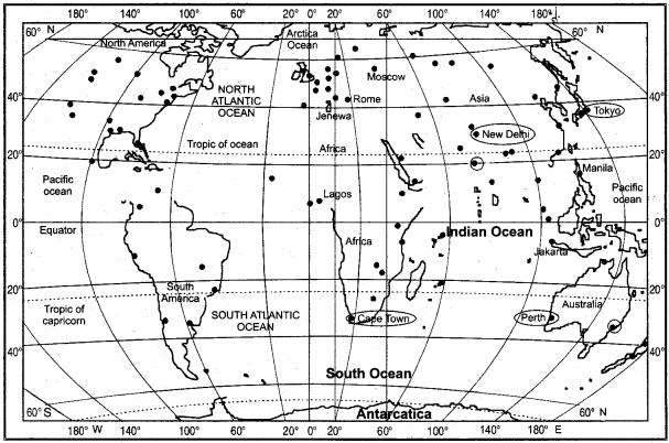
Answer: