RBSE Solutions for Class 6 Social Science Chapter 5 Maps is part of RBSE Solutions for Class 6 Social Science. Here we have given Rajasthan Board RBSE Class 6 Social Science Chapter 5 Maps.
| Board | RBSE |
| Textbook | SIERT, Rajasthan |
| Class | Class 6 |
| Subject | Social Science |
| Chapter | Chapter 5 |
| Chapter Name | Maps |
| Number of Questions | 37 |
| Category | RBSE Solutions |
Rajasthan Board RBSE Class 6 Social Science Chapter 5 Maps
Textbook Activity Based Questions and Answers
Question 1.
What is Globe? Why has it been made? (Page 36)
Answer:
Globe is a miniature model of the earth. We can get all the informations about earth while sitting at a single place with the help of a globe. This is the reason that the globe has been made.
Question 2.
What is the utility of latitudinal and longitudinal lines drawn on the globe? (Page 36)
Answer:
Latitudinal and longitudinal lines are drawn on globe. These lines are not natural, instead, they are imaginary. They are drawn on the globe to know about the actual location of a particular place in correct way.
Question 3.
Who discovered the new world (America) and when? (Page 37)
Answer:
The new world (America) was discovered by Columbus in 1492 AD.
Question 4.
Who discovered the sea route from Europe to India and when? (Page 37)
Answer:
The sea route from Europe to India was discovered by Vasco-de-Gama. He reached the Calicut coast of Kerala state in the year 1498.
Question 5.
What is meant by scale? Explain along with an example. (Page 38)
Answer:
The ratio of actual distance between two regions (places) and the distance shown between them in maps is called the scale. For example, if the actual distance between two places on earth is 10 kms and it is depicted as 1 cm on the map, then the scale of the respective map will be 1 cm = 10 kms.
(Page 39)
Question 1.
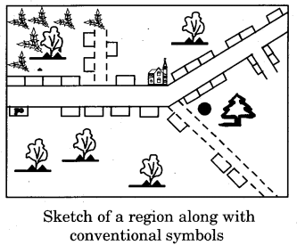
Draw a sketch without scale, using conventional symbols of your village/ colony/school.
Answer:
Following is a sketch of our colony without scale :
Textbook Exercise
Question 1.
Choose the correct option
(i) The needle of a compass always points towards-
(a) North
(b) East
(c) South
(d) West
Answer:
(a) North
(ii) Which country did VascodeGama discover via sea route?
(a) India
(b) Sri Lanka
(c) America
(d) Italy
Answer:
(a) India
Question 2.
Fill in the blanks
1. A Globe is a model of the …………… .
2. VascodeGama reached India at Calicut of ……………. state in 1498.
3. …………… machine was discovered in Europe in 16th century.
4. The Cadastral maps are generally carried by a ……………… .
Answer:
1. earth
2. Kerala
3. Printing
4. Patwari
Question 3.
What is the difference between a map and a globe?
Answer:
Globe is a miniature model of the earth. It is three – dimensional, while a map is two – dimensional.
Question 4.
How many types of maps are there? Explain any two of them.
Answer:
Maps are of various types. The main among them are :
1. Physical map
2. Political map
3. Thematic map
4. Cadastral map.
- Physical map – A physical map is one in which the physical features of the earth such as mountains, plateaus, rivers, oceans, lakes, etc., are shown.
- Political map – A map showing different cities, towns, villages, states, different nations of the world and their territories, is called a political map.
Question 5.
What is the difference between a sketch, a blueprint and a map? Also write their uses.
Answer:
Sketch, blueprint and map are sequential forms of development and use of maps. Following is their description – Sketch – Sketches are made to depict various special places. They are not drawn on a scale and they do not convey the correct proportion among different pictures, directions and distances. They are used to depict some place in the form of a raw sketch.
Blueprint – Blueprint is used to depict a small region. So, a sketch of a small region drawn with a large scale is known as blueprint. It has limited utility.
For example – a blueprint of a school building which shows all the classrooms along with their length and breadth.
Map – It is used to represent larger regions. Maps have a fixed scale. It is used to depict the distance, location, direction and distribution of a particular place in correct way.
Question 6.
Why are maps more in use than a globe? Explain.
Answer:
Maps are more in use than a globe due to following major reasons :
- In comparison to a globe, it is easier to make a map.
- It is difficult to carry a globe from one place to another, while a map can be easily carried from one place to another.
- Distribution of smaller regions, such as a town or a village cannot be depicted on a globe, while these can be correctly depicted on a map.
Question 7.
What is scale? Explain with the help of an example.
Answer:
The ratio of actual distance between two regions on the earth and the distance shown between them in maps is called the scale.
For example – if the actual distance between two places on the earth is 10 kms and it is shown on a map by 1 cm, then the scale of that map will be 1 cm = 10 kms.
Question 8.
Write about the advantages of maps.
Answer:
Following are some major advantages of maps:
- The distance, direction, shape and size can be represented on the flat surface in a map easily.
- A map contains correct information about the direction of a particular place. The north direction is shown with an arrow and ‘N’ written on the map. The opposite side of the arrow represents south.
- The actual distance between two places can be calculated with the help of the scale of the map.
- Any small place on earth can be depicted on a map.
- Maps are always drawn to scale.
- Regional characteristics are represented by conventional symbols on the map.
- Any large region of the earth can be depicted on the map by minimizing it according to scale.
Other Important Questions
Objective Type Questions
Question 1.
Which geologist was the first to show latitudinal and longitudinal lines on a map?
(a) Heketius
(b) Ptolemy
(c) Eratosthenes
(d) Strabo
Answer:
(b) Ptolemy
Question 2.
The Printing machine was invented in-
(a) 14th century
(b) 16th century
(c) 15th century
(d) 17th century
Answer:
(b) 16th century
Question 3.
The sea route from Europe to India was discovered by-
(a) Columbus
(b) Marco Polo
(c) VascodeGama
(d) Captain Cook
Answer:
(c) VascodeGama
Question 4.
The instrument which depicts the northern direction is
(a) Compass
(b) Barometer
(c) Thermometer
(d) Lactometer
Answer:
(a) Compass
Question 5.
Which colour is used to depict mountains on physical maps?
(a) Green colour
(b) Yellow colour
(c) Blue colour
(d) Brown colour
Answer:
(d) Brown colour
Fill in the blanks
1. Development of the art of …………… took place due to sea voyages.
2. …………. is used for making maps.
3. A ………… needle is present in the compass, which always faces north and south directions.
4. The drawing which depicts some major landmarks is called as …………… .
5. Sketch of a small place drawn with a large scale is known as …………….. .
Answer:
1. map
2. Scale
3. magnetic
4. sketch
5. blueprint
Very Short Answer Type Questions
Question 1.
What were the demerits of maps drawn in the ancient times?
Answer:
Maps drawn in the ancient times were only sketches, in which landmarks were shown only by drawings and they did not have a scale.
Question 2.
What was called as the Dark Age?
Answer:
The period from 3rd century AD to 12th century AD is known as the Dark Age.
Question 3.
Which persons contributed the most in providing knowledge about the continents and the oceans?
Answer:
Marco Polo, Columbus, VascodeGama, Magellan and Captain Cook were the major personalities who contributed in providing knowledge about the continents and the oceans.
Question 4.
What is meant by compass?
Answer:
The instrument used to know direction is called compass. It has a magnetic needle which always faces north and south directions.
Question 5.
What is meant by sketch?
Answer:
A sketch is used to depict a particular landmark, such as to tell about the way to some house. It does not have a scale.
Question 6.
What are symbols of traditional recognition called?
Answer:
Symbols of traditional recognition are known as conventional symbols.
Question 7.
What is meant by Thematic map?
Answer:
A map representing a particular theme or topic is known as a Thematic map.
Question 8.
What is meant by Cadastral map?
Answer:
The map that shows land ownership is known as a Cadastral map.
Short Answer Type Questions
Question 1.
Initially, how were sketches and blueprints started to be made?
Answer:
When mankind started travelling to other places for business and pleasure trips, he felt the need to make sketches and blueprints due to the following reasons :
- To get information about the correct direction and place.
- To follow the correct path.
- To be able to tell about the correct path to others.
Question 2.
Mention some characteristics of map developed by Heketius.
Answer:
Heketius developed his first map in the 5th or 6th century BC. In this type of map, he depicted the region around the Mediterranean Sea. In this map, the earth was considered to be spherical and Greece was shown at its centre. At that time, the world was divided into three continents- Europe, Asia and Africa. Then Asia was known only up to the west of the Indus River.
Question 3.
Describe the geographical directions in brief.
Answer:
An instrument called compass is used to know about direction. It tells about the north – south directions with the help of a magnetic needle. There are four major directions – north, south, east and west. In between these four directions, there are four more directions, which are respectively known as north – east, south – east, south – west and north – west.
Question 4.
What role do colours play in depicting various land forms?
Answer:
Just like conventional symbols, colours are also used to depict various land forms. Generally, rivers, streams, oceans, and other water bodies are depicted by blue colour, mountains are depicted by brown/grey colour and the plains are depicted by green colour. By knowing about these colours, we can easily and correctly depict the physical, political, cultural and environmental conditions of a particular place.
Question 5.
Mention the major characteristics of blueprint.
Answer:
Following are the major characteristics of blueprint:
- A blueprint is a photographic print of a plan for a small region drawn with a large scale.
- The time consumed in making a blueprint is less.
- The scale of a blueprint is 1 cm = 1 m or more.
- It has limited utility.
- It contains broad information about a particular region.
Question 6.
Perform a comparison of physical and political maps.
Answer:
Following is the comparison of physical and political maps :
| Physical Map | Political Map |
| These maps provide information about the physical features of the earth or land. | These maps provide information about the political features of the regions. |
| These maps depict natural land forms such as mountains, plateaus, plains along with rivers and oceans. | These show various political forms, such as countries, towns, villages and world’s countries and state boundaries. |
Long Answer Type Questions
Question 1.
What are conventional symbols? Depict msyor conventional symbols.
Answer:
Conventional (Traditional) symbols are used to depict various characteristics on a map. Detailed information about a particular region can be obtained through them. These symbols have been made on the basis of international recognition therefore they are utilized on world level. Even if we do not know the language of a particular country, we can study the map of that country with the help of conventional symbols. Following are the major conventional symbols:
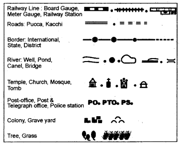
Fig: Conventional (Traditional) Signs
Question 2.
Explain the importance of maps in brief.
Answer:
Map is a two – dimensional representation of the world or some part of it. Like a globe, a map is not a model of the earth and hence when representing three dimensional things on a two dimensional surface, some mistakes occur. There are chances of variation in the size, shape and direction on a map. For example, the size of latitudes decreases while moving from the Equator towards the poles in a globe, but on maps, they are generally of the same size. This gives rise to change in shape and size of the countries lying on higher latitudes.
On the globes, the poles are almost equal to a dot, but on maximum maps, they are shown by a single straight line. In spite of that, the maps have special advantages of their own. They can be easily drawn. They can be carried and handled easily. Small villages, cities etc. can also be represented in a map. Along with this, various types of maps can be made according to the requirement and various types of information can be obtained through them.
We hope the RBSE Solutions for Class 6 Social Science Chapter 5 Maps will help you. If you have any query regarding Rajasthan Board RBSE Class 6 Social Science Chapter 5 Maps, drop a comment below and we will get back to you at the earliest.