RBSE Class 12 Geography Model Paper 1 English Medium are part of RBSE Class 12 Geography Board Model Papers. Here we have given RBSE Class 12 Geography Sample Paper 1 English Medium.
| Board | RBSE |
| Textbook | SIERT, Rajasthan |
| Class | Class 12 |
| Subject | Geography |
| Paper Set | Model Paper 1 |
| Category | RBSE Model Papers |
RBSE Class 12 Geography Sample Paper 1 English Medium
Time: 3.15 Hours
Maximum Marks: 56
General Instructions to the Examinees
- Candidates must write first his/her Roll No. on the question paper compulsorily.
- All the questions are compulsory.
- Write the answer to each question in the given answer-book only.
- For questions having more than one part, the answers to those parts are to be written together in
continuity. -
Section Q. Nos. Marks per Question Word Limit of Answer A 1 – 13 1 20 words B 14 – 21 2 60 words C 25 – 27 3 100 words D 28 – 30 4 250 words - Question Nos. 22 to 24 are related to map-work carrying 2 marks each.
- Attach outline map of World, India, and Rajasthan with the answer-book.
- There are internal choices in Question No. 29 & 30.
Section – A
Question 1.
Who is the originator of the possibilism? [1]
Question 2.
“Human geography is a synthesized study of relations between human societies and the superficies.” whose statement is this? [1]
![]()
Question 3.
What do you mean by active population? [1]
Question 4.
Write the names of any two countries included in the Low Human Development Category (less than 0.5). [1]
Question 5.
What is metropolis? [1]
Question 6.
Write any two problems of slums. [1]
Question 7.
What activities are included in fifth occupation? [1]
Question 8.
Write the names of any two renewable resources. [1]
Question 9.
What do you mean by recycling? [1]
Question 10.
When was the Nuclear Commission established? [1]
Question 11.
Write the area of India in sq km. [1]
![]()
Question 12.
Explain two objectives of the Prime Minister’s Housing Scheme. [1]
Question 13.
Explain any two reasons for low sex ratio in Rajasthan. [1]
Section – B
Question 14.
Explain economic activities of the Bushman tribe. [2]
Question 15.
Write any four factors affecting literacy rate. [2]
Question 16.
Review the transferring farming. [2]
Question 17.
What does the Cyber Space Internet mean? [2]
Question 18.
What do you mean by General Agreement on Tariffs and Trade? [2]
Question 19.
Describe two causes of acid rain. [2]
Question 20.
Write any four reasons for urban population growth in India. [2]
Question 21.
Describe the importance of forest resources. [2]
![]()
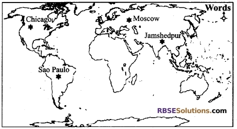
Question 22.
Mark the location of major iron and steel centres in the given outline map of the World. [2]
1. Chicago
2. Moscow
3. Sao Paulo
4. Jamshedpur
Question 23.
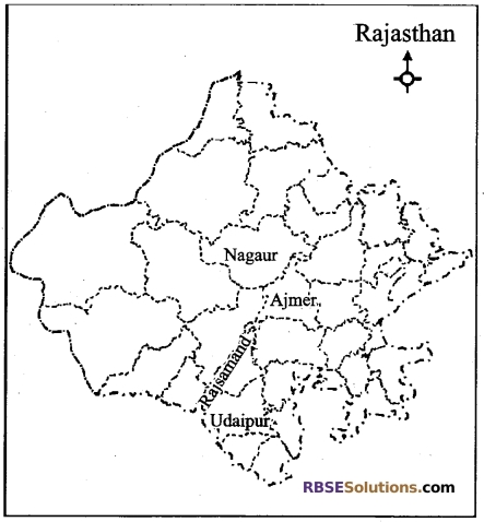
Mark the location of the major marble producing districts on the outline map of Rajasthan: [2]
1. Udaipur
2. Ajmer
3. Rajsamand
4. Nagaur
Question 24.
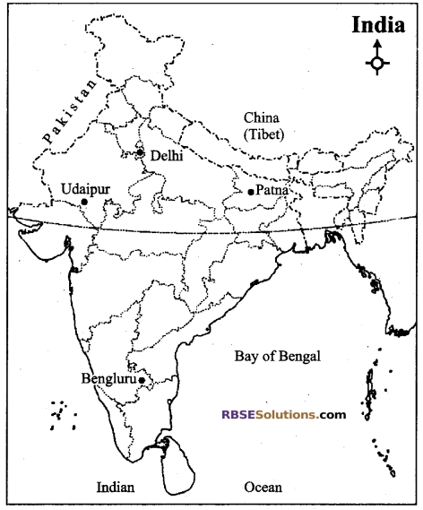
Mark the location of the major airports in the given outline map of India: [2]
1. Delhi
2. Udaipur
3. Bengaluru
4. Patna
Section – C
Question 25.
Suggest any three tips to check the growth of population. [3]
Question 26.
What do you mean by regional planning? Explain regional imbalance in India. [3]
Question 27.
Suggest any three ideas to improve the economic condition of migratory pastoral areas in the world. [3]
![]()
section – D
Question 28.
What are the advantages of pipeline transportation? Suggest better use of pipelines in western India. [4]
Question 29.
What do you mean by population density? Based on the following factors, explain the difference in the population density in the world with examples: [4]
A. Physical
B. Economic
C. Social.
OR
What do you mean by distribution of population? Based on the following factors, explain the population distribution in the world with examples. [4]
1.Location
2. Climate
3. Surface.
Question 30.
Give your suggestions for the development of dairy industry in Rajasthan. [4]
OR
Give your suggestions for the development of irrigation facilities in Rajasthan.
![]()
Answers
Answer 1:
Paul Vidal-de-la-Blouche.
Answer 2:
Friedrich Ratzel.
Answer 3:
Population living in a region (state, nation), female-male age group 15-59, engaged in various economic activities is called active population.
Answer 4:
Congo, Chad.
Answer 5:
The cities having population more than 10 lakh are called metropolis.
Answer 6:
- Unhealthy environment
- Lack of potable water, light and sanitary facilities.
Answer 7:
Legal and technical advice, executive producer, research, policymaking subject expert.
![]()
Answer 8:
Water and forest.
Answer 9:
Recycling is a very useful method of resource preservation. Reusing of resources is called recycling
Answer 10:
In the year 1948.
Answer 11:
32,87,263 sq km.
Answer 12:
- To provide financial help for accommodation to people belonging to Scheduled Castes / Scheduled Tribes groups, who live below the poverty line.
- To provide financial support to the widows / closest relatives of the martyrs.
Answer 13:
- Giving priority to the son
- Patriarchal family system.
![]()
Answer 14:
The main economic activities of the Bushman tribe are as follow :
(A) Hunting: The main economic activity of Bushman tribe’s is hunting. These people hunt with arrows and javelins. Various methods are adopted in hunting by this tribe. These people kill by trapping the prey in the mud, by throwing them into pit and making them drink poisonous water. They specialize in mimicking of the animals.
(B) Tools and Pots: These people use arrows, sharp edges, spears, barks, flames etc. These people use sharpened arrows with poison. They place sharp-edged bones of ostrich’s and giraffe’s feet on the front of their arrows. They can also kill the prey located about 60 meters away by their arrow. To make ropes they use barks of trees.
(C) Food: Bushman are omnivorous. Their diet is heavy. A Bushman can eat up to half a sheep once. Hunted animals, fish, plant roots, plums and honey are the main part of their diet. The termites, ants and their eggs are their favorite food items. These people do not care that their food is fresh or stale.
(D) Clothes: Bushmen use few clothing. The man wears a three-cornered loincloth, whose tip reaches back passing between the thigh and hips. Women wear a leather apron hanging from front and back to the waist. The most important garment in women’s clothing is ‘Chonga’, which is called Cross in the local language. This is both a garment and bedroll. (E) Residence/House. They take shelter in rocky caves. In the open, they make domed cottages with wood, twigs, grass and skin of animals. There are 8 to 10 huts in a short-lived village of Bushmen.
Answer 15:
Following are the factors affecting literacy rate: (write any four)
- Level of economic development,
- Urbanization,
- Standard of living of people,
- Social condition of women,
- Level of facilities and
- Government policies.
Answer 16:
The farming that is used by preparing the farm by burning a small part of forests by the primitive tribes for cultivation is called transferring farming. This type of farming is cultivated on one piece of land for two or three years. After this, when the land of that area starts becoming unfertile, then it is done in such a way as to go to another place. This type of farming leads to the destruction of forests. This is the ancient method of farming, This is harmful to the environment. In this type of farming method, once the farming is done, the land is left till it becomes refertile.
![]()
Answer 17:
Cyberspace is computerized space communication by electricity. It is covered by a World Wide Website (W.W.W.) like Internet. Through this, many types of social, economic and contemporary functions are facilitated to work through e-mail, e-commerce, e-education, e-governance. At present, the Internet has reached among more and more people crossing the boundaries of time and place. This is the compilation of information about the entire world.
Answer 18:
This (GATT) was the world’s first and most comprehensive international trading agreement. This agreement was signed by 96 countries on October 30, 1947. This agreement came into effect on January 1, 1948. This agreement was a multilateral international treaty that covered almost 80 percent of the world trade. It was an organization dealing with the business method of conducting international business code of conduct, which has provided a platform to various countries of the world to negotiate and solve their business problems from time to time. The World Trade Organization was established by ending its GATT on 1 January 1995.
Answer 19:
The major reasons for acidic rainfall are as follow :
- Clouding H2SO2 by chemical reaction of sulphur-dioxide.
- Excretion of SO2 by mineral oil refineries, combustion of fossil fuel and automatic vehicles.
Answer 20:
The four reasons for urban population growth in India are as follows:
- More employment facilities and opportunities in urban areas.
- Dissemination and better education facilities.
- Industrialization and facilities of civic amenities.
- Easy availability of transportation and communication sources.
![]()
Answer 21:
The importance of forest resources can be understood through the following points :
- Forests have been the birth place of civilizations since ancient times.
- Forests are national assets.
- Forests Prevent spread of desertification and attracts rain.
- Many types of direct and indirect benefits Medicinal herbs and Kendu leaves are available here.
- Forests promote biodiversity.
- Forests maintain environmental balance.
Answer 22:
Answer 23:
Answer 24:
Answer 25:
The three main tips to check the growth of population in India are
1. Increased age of marriage: The minimum age for boys is 21 years and 18 years for girls in the country’s law by the Government of India, but this law is being openly violated. If this fixed age of marriage is increased, it will increase chances of literacy and control over breeding time. This can reduce population growth.
2. Expansion of family welfare programmes: For control of population growth, public and non-governmental organizations on national level are required to carry out information about the importance of small family by spreading awareness programme among illiterate people. This will provide adequate support in population control
3. spread of education: For proper implementation of family welfare programmes, it is very essential to literate more and more people. Literacy and education is the remedy of all ills and odds of life. Educated persons understand the importance of small family and its benefits. This can be helpful in controlling growing population.
Answer 26:
Meaning of regional planning: For making and implementing a programme for proper use and development of various resources for a state, is called regional planning. In this planning policies are organized by dividing the area into regional units.
Regional imbalance in India : India has a long history of territorial inequality. At the time of India’s independence, there was a significant regional imbalance in the country. At that time, states like Bihar, Odisha and Madhya Pradesh were backward and far away from development, while these states are rich with natural resources.
K. V. Sundaram, using 14 variables, has identified low and upper-class sections in undeveloped India, which includes eastern, intermediate central and southern parts of the country. Apart from this, the problematic 5 backward regions of North-Eastern India, Eastern-Central India, Eastern Uttar Pradesh and Bundelkhand region of Madhya Pradesh, North Bihar, Uttar Pradesh and ecologically vulnerable areas such as drought prone areas, desert areas, crater areas, flood affected areas has been identified.
On the basis of the figures of 1991, regional imbalances in India appears clear,
![]()
Answer 27:
Three suggestions to improve the economic condition of migratory pastoral areas are as follows:
1. Commercial animal husbandry in place of migratory animal husbandry: If migratory pastoral areas of the world is substituted with commercial husbandry, profession their economic condition can be improved. They can earn more money from meat, wool, leather and milk as well as replace their livestock with advanced breed of livestock. The process of commercial animal husbandry can change the living standards of the residents of these areas.
2. Adopting other economic businesses by creating permanent residence: For improving economic condition of migratory pastoral areas optional economic business should be provided there. They should be provided permanent residences and other civic amenities for permanent settlement.
3. Generating contact and awareness with external environment: If these people are exposed to the people of outer environment, the level of awareness will surely develop among them. This will bring changes in their life and living conditions. Apart from all this, economic condition can improve among them through education, employment and coordination with outer world. Non-governmental organisation can play important role for this purpose.
Answer 28:
The pipeline transportation has the following advantages:
- It is a cheap source of transportation
- This is an easy means.
- This transportation format saves energy.
- It saves time.
- Pollution in this transportation format is very less.
- There is assured supply from this transportation format.
- Pipelines can also be laid through rough route and even through sea.
Tips for better use of pipelines in western India:
- Increase in power generation: Gas based electricity production can be increased by blowing gas through pipelines. Similarly, coal-based power generation can also be increased by transporting liquid coal.
- Establishment of fertilizer factories: Transporting gas through pipelines, the establishment of fertilizer factories can be promoted.
- Door to door gas home delivery: Using the pipelines door to door gas home delivery can be done which will often prove more accessible.
- Ensuring availability of water: Availability of water in more dry areas through pipelines can be ensured.
![]()
Answer 29:
Meaning of population density: The number of people living in per unit area is called population density. It shows the ratio of population and the region.
Factors Affecting Population Density
(A) Physical factors: Physical factors include location, water availability, climate and soil:
- Location: The situation of different regions of the world has significant impact on population density. Most of the world’s population lives in temperate zone. People prefer to settle on flat plains and slopes as such: The Ganga-Yamuna Plain, while mountain and hill areas are obstacles in development of transportation, hence they are not suitable for agricultural and industrial development from the beginning. Therefore, there is less population in Himalayan mountainous region.
- Availability of water: People want to settle in those areas where water is readily available. That’s why the world’s great river basins are the most densely inhabited areas of the world, whereas deserts are often thinly inhabited areas.
- Climate: The harsh climate of the hot or cold deserts is uncomfortable for human settlement. There is less population in the areas of excess rainfall or in isolated climate as such: Polar and Equatorial region, while the Mediterranean region has more settled areas since its inception due to the pleasant climate.
- Soil: Fertile soil is important for agriculture and its related activities, therefore more people live in fertile soil zones, because the soil forms the basis of intensive agriculture as such: river made plains.
(B) Economic factors: Economic factors include mining, urbanization, and industrialization:
- Minerals: Area with mineral deposits attract industries. Mining and industrial activities generate employment. A number of unskilled and skilled workers reach these areas for livelihood and creates dense population. Africa’s Katanga copper belt is a good example.
- Urbanization: The cities offer better opportunities for employment, education and medical facilities and better sources of transportation and communication. Attraction of good city facilities and urban life attract people to the cities where concentration becomes dense.
- Industrialization: Industrialization attracts a large number of people. This include workers of factories, transport operators, shopkeepers, bank employees, doctors, teachers and people of other services. Japan’s Kobe-Osaka region is densely populated due to many industries.
(C) Social and cultural factors:
Some places attract more people due to religious or cultural importance. In the same way people leave those areas where there is social and political unrest. Many times governments encourage people to settle in areas with viral populations or to move to crowded places.
OR
Meaning of population distribution: Spread of population on the surface is called population distribution. It gives more emphasis on the spatial distribution of population. In this, the positional aspects of population and regional patterns are clarified. Population distribution on the basis of location, climate and surface:
- Location: On the distribution of population, the location of different areas of the world has significant impact. Due to the adverse conditions found in high latitudes and equatorial regions, these areas show low population distribution, as- Tundra region. However, due to the favourable conditions found in the mid-latitudinal areas, more distribution of people is seen as- in temperate zone.
- Climate: Climate is an important factor in the population distribution. In areas where climatic conditions are adverse, i.e., either due to extreme cold conditions or excessive heat conditions, the distribution of population is found low as-in extreme cold areas the polar regions and in desert areas due to excessive heat. On the contrary, more population distribution is seen in areas of pleasant climate. This type of situation is seen in the Mediterranean parts of the world.
- Surface: Earth conditions are an important factor in population distribution. Often rough or uncomfortable sections are unfavourable in terms of population. For this reason, the population is less in these areas. On the contrary, areas with flat terrain are favourable with the view of human settlement. For this reason, more people reside in such areas, such as the plains built by the rivers. In these plains, the ideal conditions for housing, construction, transportation development and agriculture attract the population.
![]()
Answer 30:
Following suggestions may be given for the development of dairy industry in Rajasthan:
1. Formation of co-operative societies: Formation of co-operative societies for the development of dairy industry proves to be a meaningful step. Formation of these committees, along with milk collection, also attracts the value of milk for the people. People may start rearing milk giving as livestock, which can be obtained from these cooperative societies.
2. Availability of capital to poor families: If poor families are provided financial facilities, then poor people can also purchase advanced variety of animals, which can lead to more milking. Their economic and medical requirements can also be met with financial support.
3. Connecting villages with roads: Dairy industry can be developed by connecting villages with roads. More roads will encourage, more cattlemen. This will connect them with outer areas. This process will be beneficial for dairy industry.
4. Promoting milk based products: Dairy industry can be further developed by promoting milk and dairy products. Milk products such as butter less milk, refined butter, butter, condensed milk, cheese, ghee and milk powder, lassi etc. should be promoted in the market so that the dairy farmers can get more income and more development in dairy field can be done.
5. Increasing the number of the best breed animals: In Rajasthan, cattle rearers often do not pay attention to the breed of cattle, due to which they do not get much economic benefit from not getting more quantity of milk. If the number of animals of advanced race is increased, then there will be more milk production, which will lead to development of dairy industry. This will enhance their economic condition. Solid economic condition well improve their life standard.
6. Arrangement of suitable medical treatment and adequate food for livestock: If proper living arrangements, medical care and fooder are made for animals, there will definitely increase in milk production. This will develop dairy activities. Apart from all this, dairy industry can be developed by proper management, arrangement of artificial insemination, animal loans, establishment of animal fodder and dairy training etc.
![]()
OR
Following measures can be taken to develop the irrigation facilities in Rajasthan :
- To conserve the maximum of available water: At present, we should use the available ground surface and underground water judiciously. Much care should be taken in saving water.”
- Planning of river basins: To maintain the flow of water in rivers, adequate planning of river basins is necessary so that river water can be utilized judiciously. Misuse should be checked and controlled.
- Controlling the exploitation of underground water: Control should be established on the irregular tapping of groundwater. New boring tube well and hand-pumps should be banned in underground water scarcity areas.
- Use of fountain irrigation and droplet irrigation method: To prevent wastage of water, emphasis on fountain and droplet irrigation method should be given.
- Combination in use of groundwater and surface water: Use of equal amount of groundwater and surface water should be given for agricultural need, drinking purpose, industrial and domestic needs, so that levels of both sources remain balanced.
- Providing proper attention to the implementation of the schemes: Presently, the irrigation schemes being run by the government should be implemented in order to facilitate timely availability of water.
- Construction of farm ponds and pools: In areas where underground water situation is extremely poor, the water obtained during the rain can be used for irrigation during dry period after collecting in farm ponds or pools.
- Construction of anicut and dams: Water can be collected in the middle of the rivers or in the middle of the flowing water, by creating anicut or dams. There will also be an increase in groundwater level and this water can also be used for irrigation.
- Use of modern technology: Using modern techniques can reduce water loss due to water leakage and vaporization.
Apart from all this, irrigation can be developed by giving priority to lining of water routes and farm drains, by paying greater attention to the ongoing projects, accepting new schemes on the selected basis and giving priority to the project maintenance.
We hope the given RBSE Class 12 Geography Model Paper 1 English Medium will help you. If you have any query regarding RBSE Class 12 Geography Sample Paper 1 English Medium, drop a comment below and we will get back to you at the earliest.