Rajasthan Board RBSE Class 8 Social Science Notes Chapter 1 India Our Country
Indian Sub-Continent:
- India which is located in the South of the Asian continent is an independent geographical region. In the north west of India are Kirthar, Suleiman and Hindukush mountain ranges, the Himalayan mountain ranges cover the North-East.In north west hills of Arakanyoma which lies in west Myanmar along the coast of Bay of Bengal moves ahead from South to north and merges with Himalayas. These high mountain ranges separates Indian sub continent from rest of the Asia. Southern India is a peninsular plateau, which has Bay of Bengal in the east, Arabian Sea in the west and Indian ocean in the South.
- Every direction of this region of Asia is inaccessible and impenetrable, hence this region of India is also called Indian sub-continent. Such a regular and a huge part of land which is almost surrounded by the great amount of water is called sub continent, while a region located in continent which is geographically, culturally or environmentally complete, is called sub continent. It is geographically a special region of the Asian continent. It’s geographical location and structure have given it a special monsoon climate. Due to this reason it is also called Monsoon region.
- The high Himalayan mountain ranges in the north fetch rains in the Indian sub-continent and protect it against the cool winds from Siberia.
- In the absence of Himalayan and Hindukhush mountain ranges, the Indian sub continent would be a great desert. The perennial rivers originated from these mountains, the great plains of Ganga- Indus and Brahmaputra are created, in whose ancient Indus and Ganges valley civilizations were developed.
- There are many narrow valley and passes in the north-west and north east mountain ranges of the Indian subcontinent. Foreigners used to travel Indian subcontinent through these passes. Among them Khyber pass and Bolan pass are prominent. Passes located in the north opened the way to Tibet. From the passes of North-east to the Shyan Plateau of Myanmar. Foreigner entered in North-east regions and later spread in the other regions of India.
- People of different communities and cultures came to the Indian subcontinent in different time period. Some got mixed with presettled communities while some made their own identity. The impact of different cultures, languages, dialects, religious belief and ways of working later being affected each other. In this way beginning of the development and exchange of culture continued in Indian subcontinent and tied them into a single thread.
Location of India in world’s map:
- India lies in the north-east hemisphere. It’s mainland extends from 8°4′ N to 37°6′ N latitudes and from 68°7′ E to 97°25′ E longitudes. There is two hours of difference in the local time of Eastern and Western regions due to 29 longitudinal extension. India’s standard time is considered from 82° 30’ latitude which passes through Allahabad.
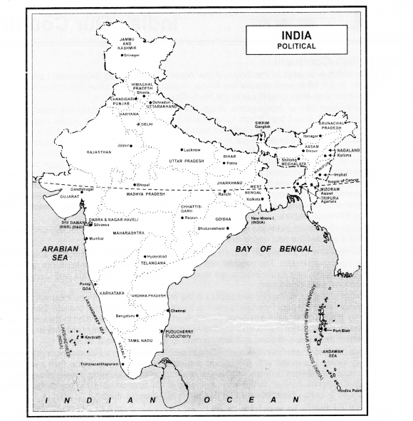
- Regarding area India is the seventh largest country in the world. Total area of India is 32.9 lac square km. The extension of India from Jammu & Kashmir in the North to Kanyakumari in the south is 3214 km and from Arunachal Pradesh in the east to Gujarat in the west is 2933 km. Regarding area Rajasthan is the largest state and Goa is the smallest state of India. For administrative purpose India is divided into 29 states and 7 union territories. Delhi is the Capital of India. Telangana became the 29th state by bifurcating Andhra Pradesh on 2nd June 2014 States, are further divided into districts for proper administration.
- India is a vast nation with diverse physical features such as lofty mountains, great plains, uneven plateaus, coastal plains, deserts and peninsulas etc. It is divided into six main physical regions namely:
- Northern and North-East mountain (Himalaya mountain) range
- Great Plain of the Ganga
- Southern Peninsula Plateau
- Coastal Plains
- Thar Desert
- Islands
North and North-eastern mountain range:
The Himalayan mountain range which is 2500 km lies in the North and North east part of India. It is the world’s highest and new mountain range. The world’s highest mountain peak is also located here. Due to its height most of the part remains covered with snow. Hence it is known as ‘Abode of the snow’. (Hima + Aalya or Abode of snow).
The Himalaya is divided into three parallel mountain ranges from south to north. They are Shivalik, middle Himalaya or Himachal and in the remote Himadri or greater Himalaya. The Himalayan mountain ranges extended from north-west to east in Arunachal Pradesh, turning from the south, merges with the Patkai and Naga hills of the Assam-Myanmar mountain range.
Importance of Himalayan ranges:
- There is a great contribution of these mountain range in our country in the continuous supply of water for irrigation .and other necessities.
- The location and structure of North-eastern ranges of the Himalayas helps in bringing rains by checking the water bearing monsoon winds from the Indian ocean.
- Most of the rainfall occurs in India through monsoon winds.
- The origin of all perennial rivers of north and north-eastern rivers are located in these mountain ranges only. These regions are the sources of many multipurpose river valley projects due to their rich water resources. It provides water management, electricity, irrigation for density populated cities. The forest area of this region has rich bio diversities, have tea and fruit plantation on the slopes, and farms of vegetables and flowers are found in the lower valleys.
- There is a great demand of medicinal herbs and shrubs found here in the whole world. The livelihood of inhabitants living here depends upon water and forest wealth. The main tourist centers are located here.
impact of Deforestation:
Due to over exploitation and deforestation caused an adverse impact on ecological balance of the environment leading to rock sliding, erosion of soil, etc. This region is endowed with rich is natural and human resources but due to unplanned and reckless human activities deteriorate the environment here:
Great Plains of Ganga:
- The great northern plains of Ganga are located in the south parallel of Himalayas.
- It is formed of alluvial soil brought down from the Himalayas by rivers-Ganga, Yamuna Brahmaputra and their tributaries.
- Due to new alluvial soil it is the most fertile land of India, it can be called ‘Granary of India’.
- The raised part of the land where every year rain water does not reach, old alluvium soil is found here. It is called Bangar. Rain water reaches every year, new alluvial soil is spread every year in the lower parts. It is called Khadar. Bangar are found in the western part while Khadar are found in the eastern part.
In the foot hills of the Himalayas the narrow plains formed from pebble and debris are called Bhabar and swampy regions are called Terai region.
The ancient civilizations originated and developed in these plains only. It is densely populated due to plain, fertile soil, favourable and sufficient rainfall. In this plain region transport and industries are greatly developed.
The Southern Peninsular Plateau:
- It lies in the south of the Ganga plain and is triangular in shape.
- On its northern boundary Vindhyachal ranges, North-west Aravali, in west hill of western ghats (Sahyadri) are located. In the east the remains of weather hills of eastern ghats. In the south Nilgiri and Annamalai mountains are located.
- The rocky and uneven land of this part has many small plateaus like Deccan, Chotanagpur plateau and mountain etc.
- India’s most mineral wealth is found in this region. The fertile black lava soil of the deccan plateau is important for the production of cotton.
Coastal plains:
in the coastal region of Peninsular India coastal plains are located on the both sides, which are formed by the rivers originated from the different mountain ranges. Due to continuous deposition and erosion by the rivers of this region-Godavari, Mahanadi, Krishna, Kaveri and Narmada, the great plains are developed in the valleys.
Due to less rain and irregularity of the plateau affects the agriculture. The traditional method of storage of water, development of modern irrigation facilities and technique of dry farming, the dependence on rains for agriculture bring down and resulting in the increase of production.
A large forest wealth is found in few areas beside spices. This region is famous for tea, rubber and coffee plantations which had attracted foreigners right from the medieval period. Most of the tribes of India lives in Vindhyachal, Satpura, Maikal, Chotanagpur and Sahyadri hills and in forests.
Islands:
Indian island groups are located in Bay of Bengal and Arabian sea. The group of 247 islands located in Bay of Bengal is called Andaman and Nicobar Islands.
Northern groups of islands is called Andaman and Southern groups of islands is Nicobar. The only active volcano of India is located on Barren island of Andaman. While Indira point located in Nicobar is the southern most point of India.
The group of 36 islands in the Arabian sea is called Lakshadweep which means one lakh dweep. This islands are famous for tourist spots.
Cultural Perspective of India:
From Kashmir to Kanyakumari and Arunachal Pradesh to Gujarat India is a unique nation filled with diversities. Culture refers to one’s way of living. Civilisation stands for own’s physical advancement whereas culture refers to the status of mental development. Culture is the knit and kith of our style, thinking, tradition, food habits, dance and music, religious belief, philosophy, language and literature. This cultural diversity is our heritage.
Language:
As per 2001 population census India has 122 languages and 234 mother tongues. Among them 22 of these languages have been accorded the constitutional status.
Generally these languages are the main language of different communities and regions. The mother tongue is that language which is speak by a mother to a child.
In our country different languages are spoken in different parts of the country like – Punjabi in Punjab, Odia in Odisha, Tamil in Tamil Nadu etc. Most of the states were reorganized on the basis of language after Independence. Hence every state can do official work in common people’s language.
Religion:
In India generally people of all religions and followers of all religious sects reside. The majority are the Hindus (78.8%), the Muslims (14.2%), the Christians (2.3%), the Sikhs (1.7%), the Buddhists (0.7%) and the Jains (0.4%).
India is the birth place of many religions like- Hindu, Buddhism, Jainism, and Sikh etc. Presence of different religion followers enhance Indian culture.
Tribal groups:
Some of the people who came to India right from pre-historic (early period) settled in in accessible areas due to geographical conditions and historical events. Later they were partially affected by the civilizations which were developing in the river valleys. Such people were called as tribals who stay in hills and dense forests.
Some of them are Bhil, Gond, Sahariya, Naga, Santhal, Oraon, etc. are living in western Gujarat and Rajasthan to West Bengal and north-western states. Their presence is negligible in plains. Economically they are the most weaker communities.
Unity in Diversity:
With all the above mentioned diversities of religions, languages and culture, India is united i.e. all are united and respect each others’ religion, community, sect and language. Thus, India is a land of ‘Unity in Diversity’.