Examine the map. What are the main differences with the map of today's India, in terms both Class 8
R
RBSEGuide
Examine the map. What are the main differences with the map of today's India, in terms both Class 8
Question 1.
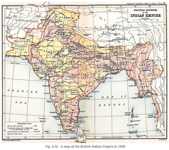
Examine the map. What are the main differences with the map of today's India, in terms both of borders and of names? (Page 105) Class 8
Answer:
This historical map of the Indian Empire shows many differences from the map of today's India. Here are the main changes:
1. Borders :
- During the British reign in 1909, India included Pakistan, Bangladesh, and Myanmar (Burma) as well.
- These countries have become separate nations now.
- The northwestern border included Baluchistan and the North West Frontier Province (now in Pakistan).
2. Some places are called by different names now.
For example:
- Calcutta is now Kolkata
- Bombay is now Mumbai
- Madras is now Chennai
- Burma is now Myanmar.
During British rule, the regions were called Provinces, Agencies, or Native States, which no longer exist under those names.
3. Territories:
- The map shows areas in pink as "British India" (directly ruled by the British).
- Areas in yellow were "Native States" ruled by Indian kings under British control.
- Today, all areas are part of the Republic of India, with states and union territories except neighbouring countries Pakistan, Bangladesh and Myanmar, which were formed later.
4. Railways:
The map also shows railway lines, which were important during British rule for transport and control.